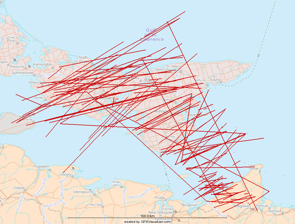
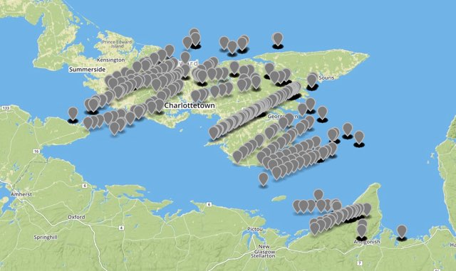
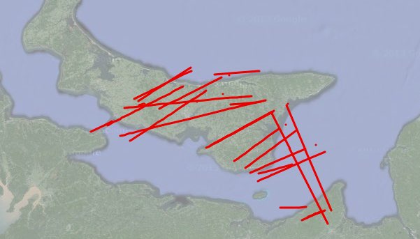
I took the overflights of PEI data that I visualized earlier for an 18 hour period and extended the visualization to include the last 5 days of overflights. Here’s what it looks like:

Five Days of Planes over Prince Edward Island

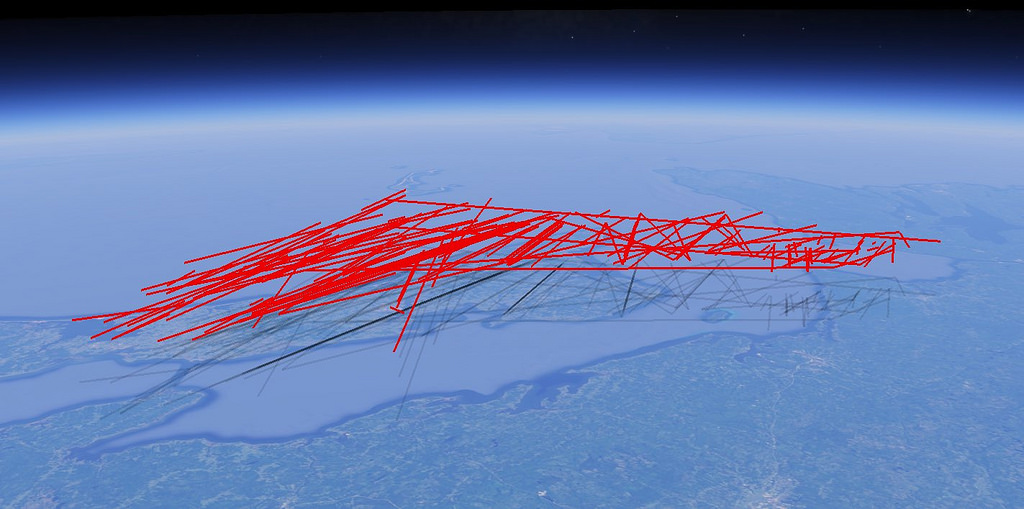
Here’s the same data, but converted into a KML file and loaded into Google Earth, with altitude as well as latitude and longitude used to draw the tracks:

Five Days of Planes over Prince Edward Island (in Google Earth)

In this image, the intensity of the shadow clamped to the ground tells you something about how frequently a given path has been followed.

Here’s the KMZ file that you can load into your own Google Earth to see the data from different perspectives.

🗓️

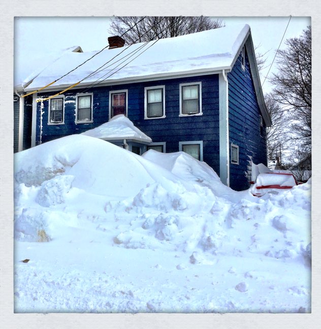
My friend Ray took this photo of 100 Prince Street this morning. As you can see, it snowed again. For almost 24 hours.

The key thing to notice in the photo, though, is that the first 2 or 3 feet of the front roof are all but completely cleaned of snow, the result of roof raking every couple of hours on Sunday. Fortunately, the wind took care of the back roof rather effectively, so I needed to spend far less time there than the last time around.

The photo is deceptive: our house isn’t actually blocked in by snow, as there’s a partially-cleared sidewalk between the two snowbanks.

But there’s still a lot of snow.

Snow on 100 Prince St.

🗓️
Snow  •  Weather  •  Charlottetown  •  100 Prince Street

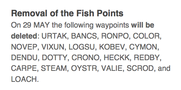
Hidden away in an obscure circular that appears to have been released in early 2014 by Gander Control is notice that a group of waypoints know as the “fish points” are to be deleted:

Fish Points

I’ve been puzzling over how aeronautical navigation waypoints get their names; it would appear, if this retirement of the “fish points” is a guide, that that are simply made up, using some sort of arbitrary theme, while ensuring that they don’t sound like other waypoint names, something reinforced in this Nav Canada circular on the same topic that reads, in part “New names to de-conflict with other similar sounding fixes on the NAT” (NAT being “North Atlantic Tracks”).

The challenge now is to connect the waypoint codes with their associated fish species. Some, like SCROD, and OYSTR and CARPE are obvious. Others, I have no idea.

Thoughts?

🗓️
ADS-B  •  Gander  •  Waypoints

So I’ve become slightly obsessed with with the world of flight planning and trans-oceanic air travel: it’s a new puzzle to solve, and it involves things flying over my house on the way to far-off lands. What’s not to love?

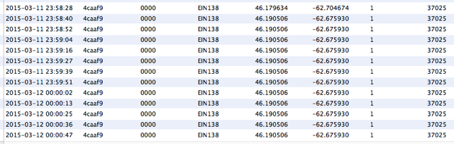
Last night around midnight, Aer Lingus Flight № 138 (code named EIN138), flying from Boston to Dublin, Ireland, flew over eastern PEI, making landfall near Point Prim, crossing south-eastern Kings County, continuing over Georgetown and Souris and heading off to sea. Here’s its track, from FlightAware.com:
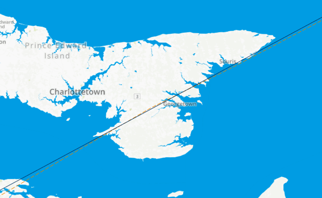
EIN138 over PEI

Looking up flight EIN138 in FlightAware provides a lot of interesting information about the flight, including a section labeled “Route” in a box on the right:
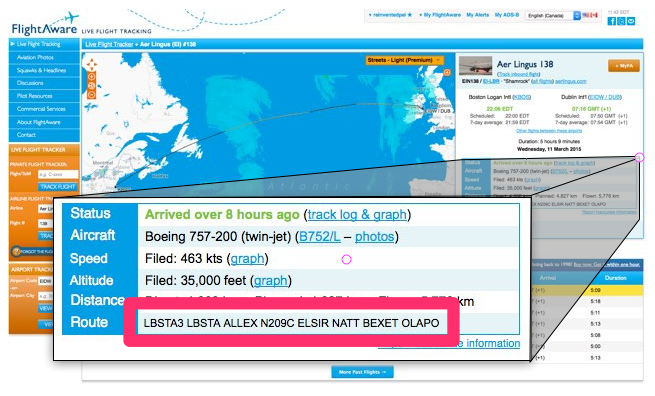
EIN138 Flight Plan

The route information is a series of “waypoints” – aeronautical bread crumbs, if you will – that EIN138 was to follow as it made its way from Boston to Dublin:

LBSTA3 LBSTA ALLEX N209C ELSIR NATT BEXET OLAPO

There is, oddly, no comprehensive database of these waypoints: there was a public resource called DAFIF, but it went dark in 2006, apparently amidst copyright concerns from Australia.

But there remain some web-based, if not open, data sources, that offer an incomplete way of looking up these waypoint codes, the most slick of which is Skyvector.com. You can simply paste the waypoints from FlightAware into Skyvector and it will, to the best of its ability, “connect the dots” (of the waypoints it knows about) and show you the flight plan on a map:
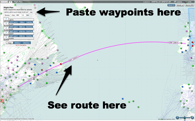
Skyvector.com in use

What’s most interesting, for my Prince Edward Island-focused purposes here, are two of those waypoints, ALLEX and ELSIR.

Zooming in a Skyvector.com, I can see the ALLEX is a waypoint at N44°25.00’, W67°.00.00’:
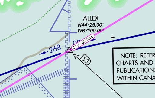
ALLEX

In decimal, that’s 44.416667, -67, which is a spot just inside Canadian airspace off Grand Manan, New Brunswick.

ELSIR, on the other hand, is at N49°30.09’, W52°0.17, or 49.5025, -52.004722 decimal, which is a spot in the North Atlantic off the east coast of Newfoundland:
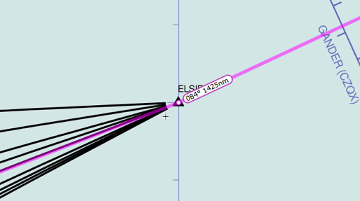
ELSIR

ELSIR is an interesting waypoint because it’s one of the official “aeronautical doorways” to flying across the North Atlantic: all airplanes flying across the ocean fly along prescribed North Atlantic Tracks, which change daily: last night, our Aer Lingus flight started its trans-oceanic voyage by passing over ELSIR.

Running between ALLEX and ELSIR is a line that happens to be labeled N209C (which also appears in the flight plan in FlightAware):
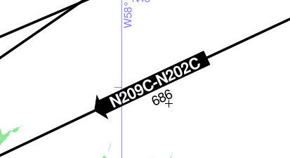
N209C

And N209C, because it connects ALLEX and ELSIR, runs directly over eastern Prince Edward Island:
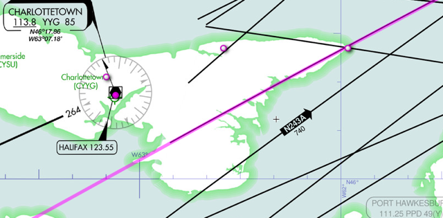
N209C

All of which means, I’m assuming, that if you see ALLEX N209C ELSIR in a flight plan, it means that the plane in question will be flying over eastern Prince Edward Island.

Meanwhile, Aer Lingus Flight № 138 landed safely in Dublin at 7:16 a.m. this morning.

🗓️

I’ve been detecting and archiving ADS-B position reports from airplanes flying over Prince Edward Island for the last 18 hours; here’s a map of what my little Raspberry Pi has picked up:

That’s a simple visualization of the positions recorded created using GeoJSON.io. To allow me to see individual planes’ tracks, I dumped the data points into a CSV file, edited it, and then ran it through GPS Visualizer:

Flights over PEI

There were 1,095 position reports received from 37 distinct flights (here’s the raw data should you wish to experiment with it yourself):

  • AAL42
  • AAL50
  • AAL78
  • AAL80
  • AAL86
  • ACA848
  • ACA878
  • AWE722
  • AWE750
  • AZA610
  • AZA65F
  • BAW196
  • BAW81V
  • CJT621
  • DAL24
  • DAL72
  • DLH425
  • DLH431
  • DLH435
  • EIN104
  • EIN138
  • ETD150
  • FDX36
  • ICE630
  • KLM18
  • N800J
  • NAX7012
  • QTR764
  • QTR8102
  • SAS926
  • SWR52
  • THY18A
  • UAL114
  • UAL126
  • UAL58
  • VIR12E
  • WJA424

You can enter those flight numbers into Google, or into FlightAware, and see the flight details: when you do this you’ll notice that the vast majority of the flights were flying above 30,000 feet and were heading to or from Europe: none of the local flights from Charlottetown Airport were detected, likely because the ADS-B receiver I’m using is on the windowsill over my office downtown, and doesn’t have line-of-sight to local flight paths.

My next step, thus, is to put an antenna up on the roof.

🗓️

When I talk to people about wind energy generation on Prince Edward Island, they are often under the impression that the wind is a relatively small part of the energy mix on the Island.

And there’s no doubt that because of its variability sometimes there is no wind energy generation on the Island. Like when the wind isn’t blowing. And that’s one of the significant challenges of wind’s contribution to the Island’s energy future.

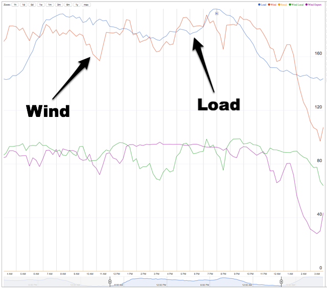
That all said, sometimes there are days, like yesterday, when the contribute of wind energy is near or above 100% of the provincial load for most of the day.

On this chart, showing 24 hours of load and generation starting at 3:00 a.m. on March 11 and ending on 3:00 a.m. on March 12, the orange line represents wind energy generation in megawatts and the blue line the province’s load in megawatts (the load being “how much electricity we’re all using together”). The wind topped the load several times during the day, including the four and a half hours from 9:30 p.m. to 2:00 a.m.

PEI Wind Energy vs. Load, March 11, 2015

🗓️
Prince Edward Island  •  Wind  •  Energy

If you’re interested in how it is that, without radar available to air traffic control, airplanes can fly over the Atlantic Ocean without flying into each other, this video from NATS about the Shanwick OCA is a fascinating one.

The video features a walkthrough of an Aer Lingus flight from Dublin to Boston, EIN137.  In a delightful coincidence, last night around midnight the return Boston-Dublin flight, EIN138, flew over Prince Edward Island at 37,000 feet:

EIN138 flies over PEI

🗓️
Video  •  NATS  •  OCA  •  Air Traffic Control  •  Airplanes

I’ve again taken the official Prince Edward Island School Calendar and updated a set of public calendar files to make it easier for parents and others to shunt the information around their digital devices. Here you go:

(Note for those of you who already had the 2013-2014 and/or 2014-2015 School Calendasr integrated into your digital devices: you don’t need to do anything, as those addresses haven’t changed from last year).

As a member of the School Calendar Committee for the PEI Home and School Federation I again asked to have the official calendar released as structured data by the Department of Education and Early Childhood Development itself, but as yet this (still) hasn’t happened.

🗓️

Longtime readers may recall that, starting three years ago, I’ve been running an AIS receiving station here in the Reinventorium in downtown Charlottetown, listening to the automated ships location broadcasts for Charlottetown Harbour and pushing the data to MarineTraffic.com.

It turns out that where ships broadcast AIS (Automatic Identification System), airplanes broadcast ADS-B (Automatic Dependent Surveillance – Broadcast) and, like AIS, these broadcasts are in the clear and can be received by any old radio capable of received on the ADS-B frequency.

Like, for example, the NooElec NESDR Nano SDR & DVB-T USB Stick that I bought for $18 last fall to support my electricity meter reading project. It was manufactured as a European digital TV receiver, but, under the hood, it’s a software-defined radio capable of receiving radio from 25MHz to 1700MHz.

What’s more, just as MarineTraffic.com aggregates AIS reports, FlightAware.com aggregates ADS-B reports, and it has a Raspberry Pi distribution that makes sending data their way as easy as burning an SD card.

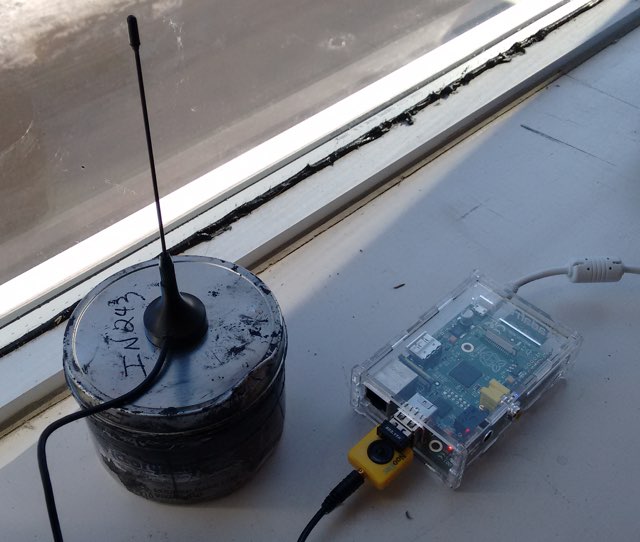
So, of course, I built one.

PiAware in the Reinventorium

You can follow along on my FlightAware status page, which lists flights detected in various formats.

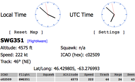
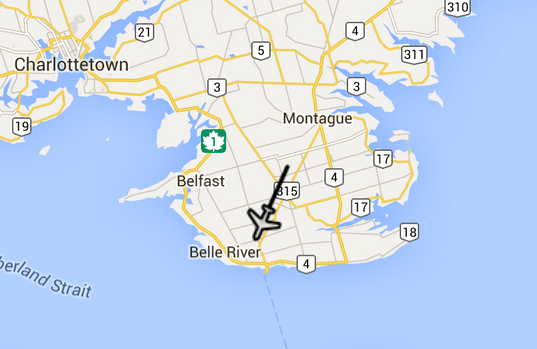
And sure enough, the system worked: here’s what Sunwing Flight 351 from Cuba to Charlottetown looked like on the local status page as it was coming in to land this afternoon just before 4:00 p.m.:

Sunwing 351

And here’s flight RRR4520 flying at 27,000 feet high above the Valleyfield Road:

It all seems like magic. But it’s just radio waves.

🗓️
ADS-B  •  Airlines  •  Airplanes  •  Radio  •  Raspberry Pi

The Charlottetown Guardian unveiled its new design this morning, part of a redesign of all of parent company TC Media’s local newspapers called “Project Orange” internally. On the left is Saturday’s pre-redesign cover; on the right is this morning’s newly-orange front:

The Guardian Design, before Project Orange

It’s an interesting – and somewhat bizarre – move to paint all the company’s papers with the same orange brush (the exception is the Journal-Pioneer in Summerside which is turning blue instead of orange), especially given that one of The Guardian’s strengths locally has always been that, despite its rotating cast of parent companies, it’s always been strongly identified as a local paper, not an “outlet” of a corporate brand.

That this morning’s Guardian looks an awful lot like this morning’s Telegram in far-away St. John’s might make sense of some sort of corporate synergasm way, but I’m not sure why it’s required or even preferable when looked at from the ground. Doesn’t our community deserve a newspaper designed and built by Islanders for Islanders? What’s the upside for the reader in brand unification?

There’s also the issue of the web and the attention span: the redesign brings with it a collection of the short and snappy – the “quick questions” and the “things to know” and related factoid boxes – and an aversion to the beautiful grey expanse of type the defined The Guardian – and newspapers in general – for a good part of their lifetime. The aversion to grey isn’t new here, of course, and it’s not unique to TC Media: big photos and fact boxes have been a part of The Guardian’s recent incarnations, albeit to a less dramatic extent.

Philosophically I’m on a different page from where newspaper design is heading; I think the reaction to the web should be to go long and go deep and go grey and go big. In that I am, alas, perhaps alone. But man was 1964 ever a great year for newspaper design on Prince Edward Island:

1964 Guardian Front

🗓️
#FF5900  •  Orange  •  Newspapers  •  Design  •  The Guardian

About This Blog

Photo of Peter RukavinaI am . I am a writer, letterpress printer, and a curious person.

To learn more about me, read my /now, look at my bio, listen to audio I’ve posted, read presentations and speeches I’ve written, see things I’ve favourited elsewhere, or get in touch (peter@rukavina.net is the quickest way).

I have been writing here since May 1999: you can explore the 25+ years of blog posts in the archive.

You can subscribe to an RSS feed of posts, an RSS feed of comments, an RSS feed of favourites elsewhere, or a podcast RSS feed that just contains audio posts. You can also receive a daily digests of posts by email. I also publish an OPML blogroll.

InstagramYouTubeVimeoORCIDOpenStreetMapInternet ArchivePEI.artDrupalGithub.