
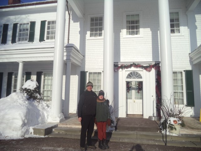
Oliver turned 13 in 2013 (was there ever a more handy mnemonic!) and, given that he’s a teenager now, and a curious one at that, it seemed like the right year to elevate him to my official New Years Day levee-attending partner. He was game – enthusiastic even – and so we printed out the schedule, got warmly dressed for the -20ºC weather and called a cab for the hyperjump from Prince Street to Government House as a way of starting off gently.
Our timing was perfect: a gentle line and a roaring fire greeted us. And the rest of the day – 12 levees over 6 hours – went just as well. Oliver jumped into the levee cauldron with both feet, and by the end of the day when he shook Premier Ghiz’s hand, he was a master of the “Happy New Year.”
In the spirit of inspiring levee excellence, and after careful consulation with Oliver, here are the winners of the official 2014 Levee Awards:
Best New Levee: Queen Street Commons, with Trinity-Clifton United Church a close second. The Commons clinched this one with a nice mixture of people and food, and more well-turned-out-young-rockers than all the other levees combined.
Best Food, Catered: Premier Ghiz, no contest. From the “make your own mashed potato sundae” bar to the potato chips (the thick kind!) to the endless array of desserts and the well-constructed punch, we were able to skip both dinner and supper.
Best Food, Homemade: The Masonic Temple’s banana bread was top-flight.
Best Alcohol: The Caledonian Club – another new levee this year – served a nice scotch, which was an unexpected treat. Honourable mention to Engineers PEI for a very nicely engineered sangria.
Best Costumes: A tie between the Bishop of Charlottetown, well-turned-out in his purple Bishop uniform, and the chap at the Masonic Temple wearing a crown, cape and carrying a sort of walking-stick-cum-magic wand.
Best Music: PEI Regiment, hands down. Not only is the regimental band a crack outfit, but they defy stereotypes by playing rousing renditions of Cyndi Lauper and Queen hits.
Most Ubiquitous Attendee: Wes MacAleer has won this every year for the past decade, but actor and bon vivant Bill McFadden surpassed him this year, with honourable mention to Guardian scribe Doug Gallant, who came close. That all said, I did see Wes three times today.
Most Improved: City of Charlottetown. After some dry years with bad catering, they’re back in fine form at City Hall. The City Police choir was a nice addition.
Best Swag: Lieutenant Governor Lewis was handing out 2014 Fathers of Confederation calendars and PEI2014 pins.
Best Receiving Line: PEI Regiment. Those soldiers look your right in the eye when they shake your hand, and they mean it when they say “Happy New Year.”
Most Informal: The Haviland Club used to run a military-style levee, with a formal receiving line and an Officers’ Club vibe. They’ve transformed things into a much more informal “thanks for stopping by our rec room; have a bagel and a sit-down out of the cold” style. The transition is confusing – especially their switch to a counter-clockwise rotation through the building – but it’s not an unwelcome change.
Happy New Year!
Back at the beginning of December I decided that it would be nice for the Minecraft-interested people of the Charlottetown area to get together to watch Minecraft: The Story of Mojang, a film about the people who make Minecraft, the people who play Minecraft, and the phenomenon that surrounds both.
Contacting the Filmmakers
To start things off I emailed the producers of the film to inquire about how much it would cost for rights to screen the film; four hours later I got a reply: “cool, yeah, you should do it. we normally ask for a screening fee but since it’ll be free, we can wave that.”
So, that was easy.
Finding a Venue
Having my office cheek by jowl with the theatre at The Guild made it the logical venue for the screening, so I sent off an email to Michelle, the event liaison for The Guild, and she got back to me with the rental cost:
| Item | Cost |
|---|---|
| Theatre Rental ($55/hour for 2 hours) | $110.00 |
| Technician ($25/hour for 2.5 hours) | $62.50 |
| TOTAL (with tax) | $196.65 |
As I’d agreed with the filmmakers to show the film for free, I couldn’t recoup that from admission fees, and while I might have been able to find sponsors to cover the cost in the end I decided to dip into my own pocket to make it happen with no fuss and no muss, so I sent off the word to Michelle, and later in the week I signed a contract to screen the film at 4:30 p.m. on Friday, December 27, 2013.
For this I would get not only a technician to handle the projection setup, but also an event manager to handle the space and a canteen.
Ticket Reservations
The capacity of the theatre in The Guild is 144, and to avoid too many people showing up, I needed a system for allowing people to reserve tickets, so I adapted the Drupal-based system I created for Minecraft workshops in the spring, which uses Node Registration, for this purpose and opened the “ticket office” on December 14.
Publicity
To publicize the screening I did a number of things:
- Put the word out on Twitter and Facebook.
- Posted on the Hacker in Residence blog.
- Submitted an event to the community calendars at The Guardian, the CBC, the Buzz and at UPEI.
Then I stepped back to see what the interest was. The first tickets were reserved about an hour after the reservation system went up, and by Christmas Eve all 130 tickets I’d put out for reservation were spoken for (I wanted to leave a buffer for last minute “I didn’t know I needed tickets!” people and to leave all of the seats with a good sightline).
I had a CAPTCHA in place to cut down on spam-reservations, but still got about half a dozen, which was annoying, as they all came near the end and took up spaces that could have gone to others, but I was generally able to cancel these quickly.
Cancellations
I sent out a reminder email on December 26 to all those who had reserved tickets, asking anyone who had to cancel to let me know so that I could open up their tickets for others; I got about a dozen emails in reply (hockey tournaments being the culprit in most cases) and this allowed all the people on the unofficial “waiting list” to reserve tickets.
Technical Setup
The film itself I had already purchase a 720p download of from the filmmakers’ website; I connected a Thunderbolt-to-VGA adapater for my MacBook Air, and this got plugged into a long VGA cable the ran into The Guild’s screen projector. The sound came through a stereo-mini plug provided by The Guild and plugged directly into their PA. All of the technical futzing around was accomplished by Eric, The Guild’s technician, and having him worry about sound and contrast and setup was more than worth the $62.50 I paid for his services.
The film was projected on the white-painted wall at the back of the stage at The Guild. The screen projector sent out a very nice image; the sound was amazing (who knew a little MacBook Air was capable of so much!); the only downside, and it was a small one, was the seams in the plywood wall were sometimes more visible than I would have liked.
Did anyone show up?
The first guests arrived around 4:00 p.m. and by 4:30 p.m. everyone was in their seat. In the end about 70 people, of the 130 tickets originally reserved, showed up for the screen. Some people cancelled in advance; others simply didn’t show up at all, which was kind of annoying, as their seats could have, in theory, gone to others. But that’s the price paid for a free showing where there’s no penalty for not showing up, and the upside of making the screen available to all made it worth it. Besides, everyone got a good seat as a result.
The film ended up costing me $2.81 per person to screen, which is a pretty good deal for spreading the word about Minecraft and creating a family outing for the holidays. Most people who came reserved 3 or 4 tickets and there were as many parents in the audience as children. I’d cautioned, in my publicity, that the film was long – 1 hour and 44 minutes – and this likely scared off parents with younger children concerned about attention span.
I think we only lost about 4 people mid-screening; everyone else stayed for the duration, and all the comments I received after the screening were positive.
Watch it Yourself!
If you missed the screening, you can download or stream the film for as little as $8 from the Minecraft: The Story of Mojang website; if you’re at all interested in the world of Minecraft, or if you have kids who are and you want to understand more about it, I highly recommend you take a watch.
Our Nintendo Wii has had a YouTube app available for it for a while now. We installed it when it first came out and it was dreadful enough that we never used it: videos took forever to buffer, the UI was weak, and there was no integration with other ways in which we interact with YouTube.
Slowly but surely the app has improved: it’s not up to Netflix-level “play as soon as I click play” yet, but it’s much better, and once videos start playing they rarely re-buffer. The UI is much improved, and it’s now possible to pair the Wii app with a portable device like an iPhone or iPad so that you can use the device as a sort of “visual remote” for what’s showing on TV.
The end result of all this is that we’re starting to “watch YouTube” almost as much as we watch Netflix and are uncovering some great stuff in the process. Here’s a sampling of things we’ve enjoyed recently:
- Pogey Beach — the “show within a show” of Jeremy Larter’s Just Passing Through (also worth watching; also on YouTube). Thanks to brother Johnny for the pointer.
- Make Me a German — a British family relocates to Nuremberg for a month to try to simulate life as a “typical German family.” An interesting look into some of the minutiae of everyday life in Germany.
- Jack Conte at XOXO — Conte is one half of Pomplamoose and founder of Patreon and his talk at the XOXO conference is an interesting “behind the scenes” look at both.
- Engineering Connections on Burj Al Arab — It’s not quite Connections in the James Burke mold, but it’s still interesting. Hosted by Richard Hammond (Top Gear), each episode takes a modern engineering marvel and traces back bits of tech to their engineering origins.
- The Secret Life of the National Grid — perhaps only truly interesting to electricity grid geeks like me.
- Frosty the Snowman — Oliver’s stop-motion animation project. On TV!
- Around the World in 20 Years — Michael Palin revisits his “Around the World in 80 Days” project from 20 years ago, and tracks down the crew of the dhow that took him from Dubai to India.
- Amazon’s Truth Behind the Click — a BBC Panorama documentary that sends an undercover worked into an Amazon.co.uk warehouse and reveals a lot about how Amazon runs its business at that level.
- Mechanical Marvels — a BBC documentary about automatons; there’s some amazing old tech covered.
- Tonight You Belong to Me — One cannot live on serious BBC documentaries along: this is a silly little video of a father and daughter singing a duet; it brings joy to my heart.
- Dogs Teaching Chemistry — I learned about ions, and so can you.
- WKRP, Venus Explains the Atom — Everything I know about protons, electrons and neutrons I learned from Gordon Simms.
- CBC Land and Sea on Charlottetown Farmer’s Market — I loved this documentary so much that when I aired on the CBC I screen grabbed it and posted it on YouTube where 550 people have watched it. If you love the Market, this is a good look back.
If you’re casting about on YouTube looking for something to watch, a keyword search for “BBC documentary” will almost never steer you wrong.
Oliver showed me ChaosInYourTown.com this morning. While it’s essentially a virality-baiting ad for State Farm, it’s imaginatively done, and, other than a few rendering hiccups, an impressive technical mashup. Here’s an excerpt from running the site pointing at our house:
You would think that after, say, the first two or three hundred, the process of printing coffee bags on the Golding Jobber № 8 would get, well, a little repetitive. Especially because printing two-colour coffee bags means printing one colour, cleaning up, and printing the second colour.
But repetition is kind of the point: letterpresses are machines meant for mass production, and so becoming proficient at the printing trade means becoming proficient at repetition.
Today I took a big leap in that regard.
The coffee bags themselves are ornery things to print on: foil bits hanging out, folds in annoying places, and about 5 times thicker than a regular sheet of paper. My lack of proficiency, combined with this orneriness, has meant that, for the first four or five hundred bags, I’ve been printing a bag, throwing off the press, taking the printed bag out, putting a bag in, and throwing the press back on, wasting 3 or sometimes 4 or 5 cycles of the press in the process.
Try as I might I could never coordinate all the movements to do this all in one smooth motion.
Until today.
Today, by dint of repetition, favourable humidity (meaning less stickiness), and disposition of the printing gods, I cracked the code.
I was on fire. It’s amazing how quickly you can print when you’re actually printing at the press intended, with one impression per cycle.
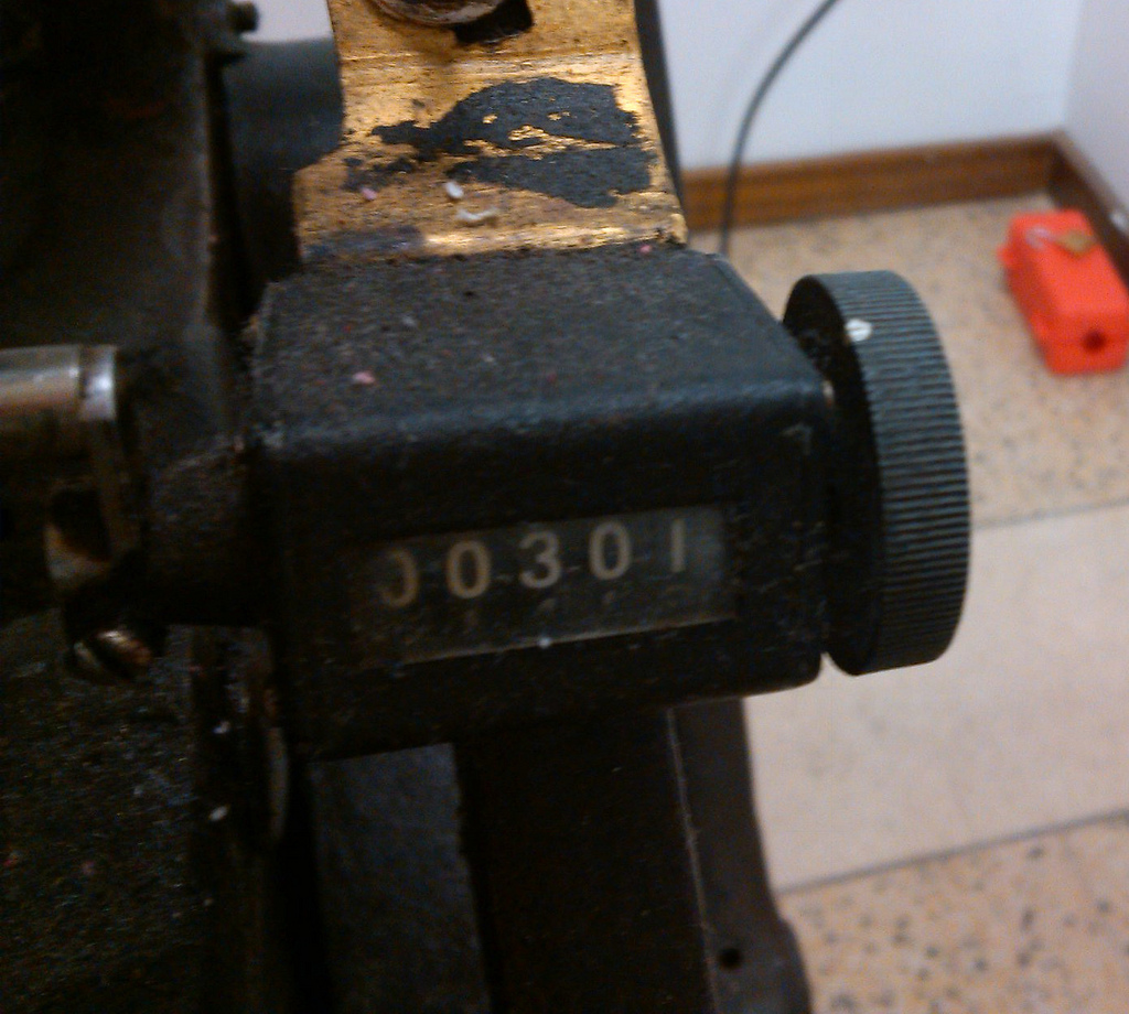
So in short order I was able to crank out 301 coffee bags. Or at least the black impression thereof.
Tomorrow I’ll go back in to print the red; I hope the gods continue to favour me.
This week’s letterpress project was large coffee bags for ROW142. These bags, used for wholesale coffee (or for particularly eager retail customers), are about four times larger than the smaller retail bags I printed earlier and they’re of a different material (foil-lined rather than plastic) and design.
My original plan was to simply copy the “down the middle” design I used on the smaller bags, but that proved challenging, as on the back side of the bags is a thick seam that, despite my efforts to compensate for it by buttressing around it, I couldn’t get a consistent print. So I modified the design to run ROW142 down the right side of the bag and, in the end, I’m actually happier with this design.
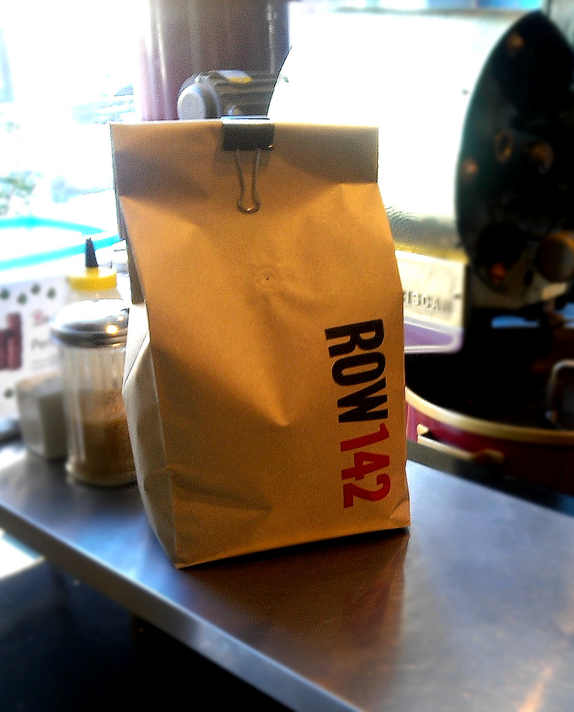
If you want to buy a massive amount of coffee beans, the bags are in the shop now ready for purchase. Next up: print more of the smaller bags, as they’ve already run out!
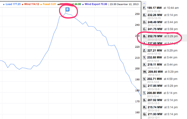
Prince Edward Islanders were using more electricity last Thursday than ever before: the peak load at 5:29 p.m. was 252.70 MW, which is 7.6 MW more than last winter’s peak on January 23, 2013.
You may recall that when the PEI Energy Commission released its findings a year ago it reported:
The cables are now 35 years in service and the province’s peak load exceeds 220 MW . Current projected load growth for Prince Edward Island is 1 .5% to 2% per year which may push the peak load into the 250 MW range by 2018.
So we’re 5 years early on that prediction.
I’m organizing a free showing of the film Minecraft: The Story of Mojang here at The Guild on December 27, 2013 at 4:30 p.m. Everyone is welcome, and tickets are free, but you must reserve them in advance. Get tickets and complete details over at the Hacker in Residence blog. Everyone is welcome.
The Province of PEI has released a Request for Proposals, with an incredibly tight 9-day window for response (responses are due December 20, 2013), for the development of a “Education K-12 Technology Strategic Plan.” It’s a substantial project with two threads:
Development of five year technology strategic plan which aligns leading educational research in instructional strategies, critical thinking and other 21st century skills, as well as educational technology with provincial top achievement priorities;
Assessment of the current IT infrastructure and identification, quantification and prioritization of initiatives to ensure the IT infrastructure is optimized for the delivery of services to Education.
The project is to start in January and finish in April, and the result will be a template that will guide the use of technology in education in the province.
This is a process that demands an broadminded, technology-literate educator, not a “computer consultant” and I fear that the short time to respond to the RFP will unnecessarily limit the responses to it.
If you or someone in your network would be interested in and capable of conducting such a project, I encourage you to pass along the tender documents. Quickly.
 On Friday, December 27, 2013 at 4:30 p.m. at The Guild I’m organizing a showing of Minecraft: The Story of Mojang, a film about Minecraft, the people who make it and the people who play it.
Tickets are free, but you must order them in advance online.
People of all ages are welcome: the film provides a great look into Minecraft culture; it’s a “behind the scenes” look at how a Minecraft came to be.
The film is long – it runs 1 hour and 44 minutes – please keep that in mind when considering whether attend or not.
We’ll be showing the “family friendly” version of the film, which has the “adult language” bleeped out.
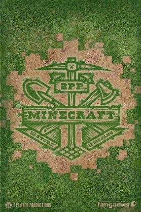
This event is made possible due to the generosity of the filmmakers, 2 Player Productions.
Watch the trailer for the film.
Update: read How to Show a Film at The Guild for details of how I booked the film and how the screening went.
About This Blog
 I am Peter Rukavina and this is my blog. I am a writer, letterpress printer, and a curious person.
To learn more about me, read my /now, look at my bio, listen to audio I’ve posted, read presentations and speeches I’ve written, or get in touch (peter@rukavina.net is the quickest way).
I have been writing here since May 1999: you can explore the 25+ years of blog posts in the archive.
You can subscribe to an RSS feed of posts, an RSS feed of comments, or a podcast RSS feed that just contains audio posts. You can also receive a daily digests of posts by email.