
I’m off to New England tomorrow afternoon for the first time since January.
I’ll be spending Monday night through Friday in southern New Hampshire, working with my colleagues at Yankee Publishing on Almanac.com and YankeeMagazine.com.
On Friday night I’m spending the night in downtown Brattleboro, Vermont – one of my favourite towns – staying at the Latchis Hotel for the first time. It’s part of a complex that includes a movie theatre, so what’s not to like?
Early Saturday morning I’ll head down I-91 to Chicopee, Massachusetts to visit Letterpress Things for the first time – “unique store for type and tools, supplies and materials, presses and other items for the letterpress printer.”
And then I’ll head west to Hillsdale, New York to visit our friends Ian and Tessa who I haven’t seen since the last Zap Your PRAM 7 years ago (!).
Saturday night I’m whizzling back to the Boston area, staying overnight in Burlington, and Sunday morning I fly back to the Island.
Perhaps our paths will cross?
Canada’s Chief Electoral Officers – the federal, provincial and territorial officials responsible for the conduct of elections in their jurisductions – held their annual meeting here in Charlottetown on Monday, July 20, and I was asked to speak to them on open data in the same spirit I spoke to the Queen’s Printers Association of Canada last month: open data from a user’s perspective.
I honed the presentation for the elections-focused audience, and I winnowed down my “open data principles” to 5 (from 7), both for time and focus, leaving me with:
- You have no idea (at all) what open data might be used for.
- PDFs are where data goes to die.
- Sometimes “open” can simply mean following rules of design.
- Open data is a conversation.
- Sometimes your users will create open data for you.
I used my work to liberate the recently-released White Paper on Democratic Renewal here on Prince Edward Island as an example of a project that touches on each of those principles.
Although the slides I used for the presentation are less meaningful with out me to walk through them, I’m providing them in a variety of formats, under a Creative Commons license, with hopes that others might build upon them.
- Keynote 6 (47 MB)
- PDF (18 MB; does not include audio clips)
- HTML (exported from Keynote as a “playable” presentation)
- JPEG (26 MB; 87 images, one per slide, in a ZIP file)
- Speaker Deck (web-embeddable)
Logistics for the meeting were expertly handled by the Canadian Intergovernmental Conference Secretariat: the screen projector and audio setup was painless, and my presentation was simulataneously translated into French (leaving me to wonder how idioms like “and once the horses were out of the barn…” were translated).
I went a little wild this afternoon taking the White Paper on Democratic Renewal, released in the Legislative Assembly today, and liberating it from its PDF prison into a variety of more open formats (like ePub, HTML and plain text).
Once the text was out there in the open, I kept right on going, pasting the plain text into TextEdit in my Mac and using the OS X “Add to iTunes as Spoken Track” to convert the text into speech. I then brought the resulting MP3 into GarageBand and added a techo backing track, and then uploaded the result to SoundCloud.
While the text-to-speech is clunky and awkward by times, it’s still remarkably good, and I’m surprised by how much more listenable it becomes with its techo backing.
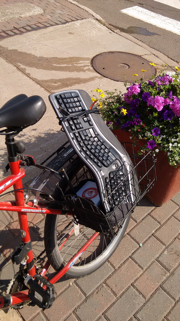
I arrived at Charlottetown City Hall this morning on my bicycle only to find that the single bicycle rack in front of the building already had a bicycle attached to it, with the space for a second bicycle blocked by a concrete flower planter:
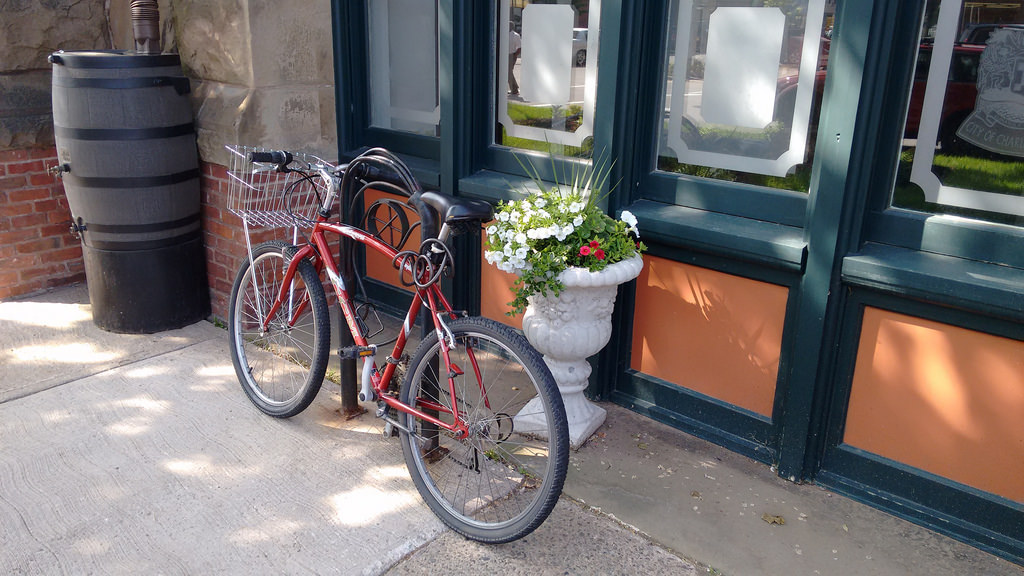
I thought of various ways I could deal with this – angry letters to the Mayor, snarky tweets about “does the city really care about sustainability,” and so on.
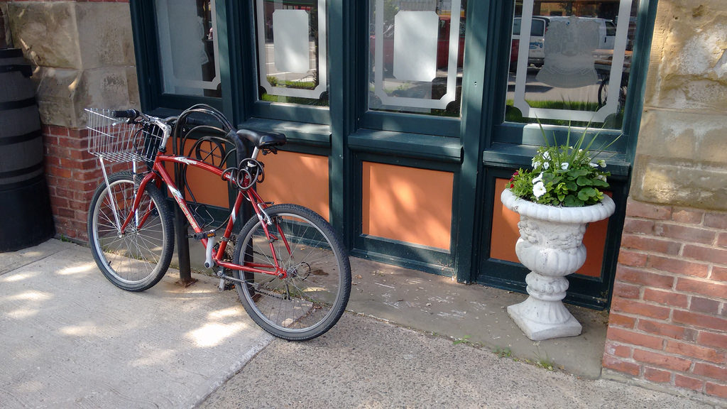
Instead of any of those, I simply moved the concrete planter:
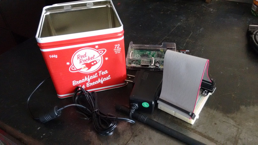
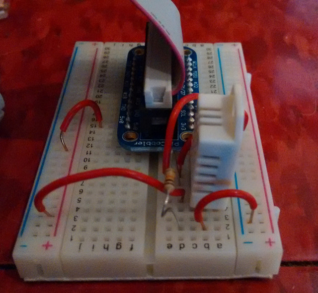
As one of the households in my Social Consumption Project project moved out of town, I was left with a spare Ledbetter board and Raspberry Pi to deploy elsewhere. So I turned to the City of Charlottetown’s Sustainability Coordinator with the suggestion that I install this in City Hall. And she readily agreed. And today was install day.
In preparation, I enclosed the Pi and the breakout board in a new enclosure (as detailed here):
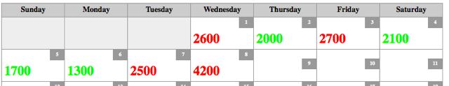
I tested the updated setup here in my office in The Guild for a week; here’s the daily water consumption in litres over that week (yesterday there were three shows in the theatre, so lots of washroom use, hence the uptick in water consumption):
This proved robust (the tin container interfered with neither the USB wifi dongle nor the Ledbetter board’s abilities) and so I was ready to install in City Hall. I loaded up my bicycle and headed that way:
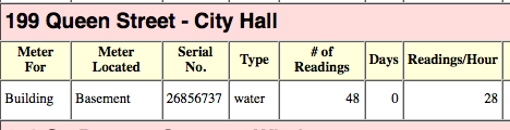
The first task at City Hall was to locate the water meter and obtain its serial number. With some guidance from Public Works, we headed to the basement and found it on the Queen Street side in the utility room:
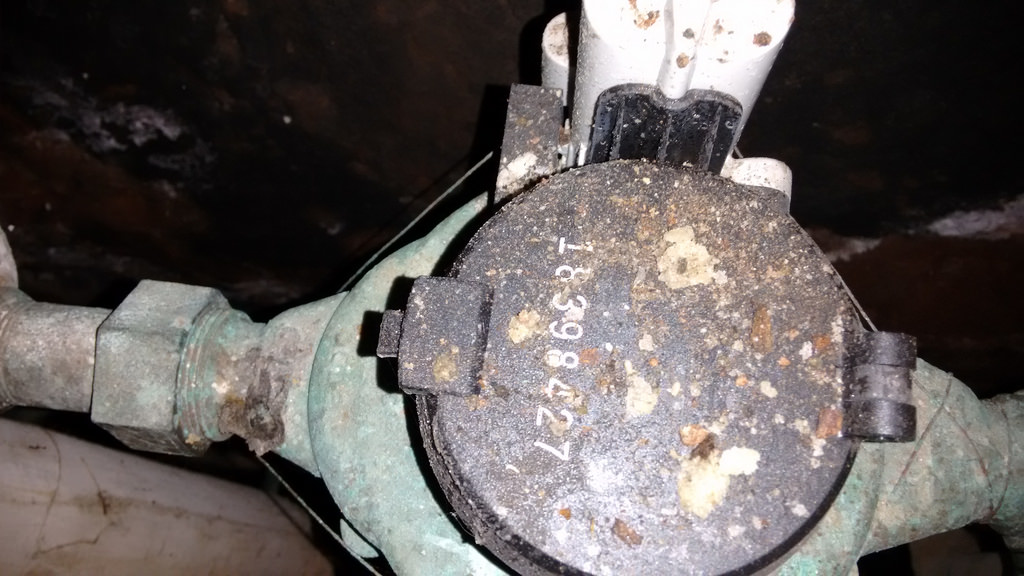
On the wall-wide was the Itron radio meter reader, with its serial number facing the wall, so I had to stand on a chair and use my mobile phone’s camera to take a photo of it, which took a few tried, but ultimately worked:
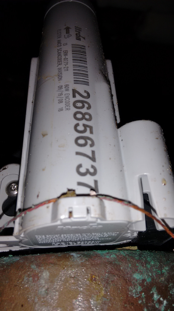
The meter’s serial number is the big number – 26856737.
Next, we found the City Hall electricity meter outide the building in the alley off Kent Street:
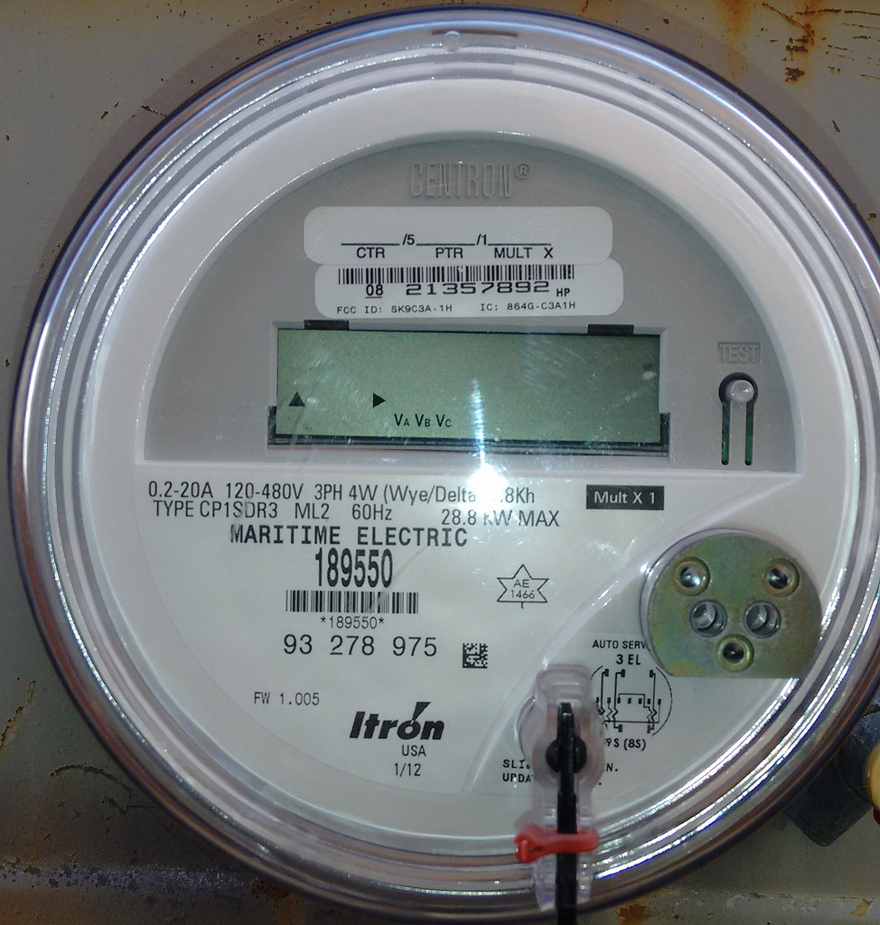
I knew enough from experimenting here at The Guild that this is a 3 phase meter (the 3PH and the meter type of 8 next to the bar code are the giveaways), and that, as a result, the Ledbetter board wouldn’t be able to read it because it’s specifically programmed to skip over the frequency range of that meter type, so we set electricity meter reading aside and concentated on water meter reading.
Up on the second floor of City Hall I got connected to the guest wireless network. This is a closed network, so I needed a wifi password to connect to it, which meant that I had to connect the Raspberry Pi to a keyboard (which I brought) and a monitor (which I borrowed, via a HDMI-to-VGA adapter I brought along just in case). Connecting to the wifi was no problem, but I soon discovered a couple of limitations of the City Hall network setup:
- Devices connected to the network cannot see each other, even if they’re on the same subnet. This isn’t unusual for a guest wifi network, as its primarily intended for visitor use, and visitors would have no need to have their devices see other devices on the network; for my purposes, though, it meant that I couldn’t connect to Node-RED running on the Pi from my MacBook Air on the same network, which made it hard to see if things were working properly.
- Devices connected to the network cannot connect to the Internet on port 22, which prevented me from SSHing, or tunnelling over SSH, to my external database server to see if data was flowing from Node-RED to the database.
I was able to work around these issues by connecting my MacBook Air to a wifi hotspot on my Moto G mobile phone, which allowed me to SSH to my external database server and to confirm that data was, indeed, flowing from the water meter with serial number 26856737 that we’d found in the basement; I could then add the serial number to my list of recognized meters, and the data started to appear on my internal dashboard:
With everything working as it should, I unplugged everything, set the “Red Rocket Pi” in an out-of-the-way corner, and left it to continue to log data.
The city’s sustainability committee now has to meet to decide whether the data on City Hall’s water consumption can be made public; that should happen in the next few weeks.
Here are the steps I took to install Node-RED on my Raspberry Pi B, and then to wire it up to a DHT22 humidity and temperature sensor to log the conditions in my office. It’s based on my work last year using Node-RED to log electricity and water consumption data.
First, I wired up the DHT22 on a breadboard connected to my Raspberry Pi’s GPIO port by ribbon cable, using the helpful Adafruit guide here. The result looked like this:
Next, I installed Node and Node-RED, as detailed here:
wget http://node-arm.herokuapp.com/node_0.10.36_armhf.deb
sudo dpkg -i node_0.10.36_armhf.deb
sudo npm install -g --unsafe-perm node-red
That last step took a while (5 to 10 minutes). I was patient.
Next, I installed DHT22 support for Node-RED, first installing the bcm2835 library:
wget http://www.airspayce.com/mikem/bcm2835/bcm2835-1.58tar.gz
tar zxvf bcm2835-1.58.tar.gz
cd bcm2835-1.58
./configure
make
sudo make check
sudo make install
And then:
sudo npm install --unsafe-perm -g node-dht-sensor
sudo npm install --unsafe-perm -g node-red-contrib-dht-sensor
I then started up Node-RED:
node-red-start
I was then able to see Node-RED from a browser at http://hostname-or-ip-address:1880/
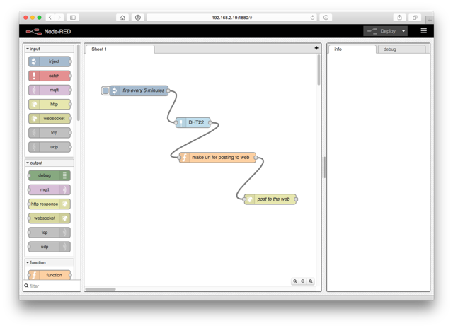
I created a Node-RED workflow to read the temperature and humidity every 5 minutes and upload it to a PHP script on my webserver that squirrels it away in a MySQL database:
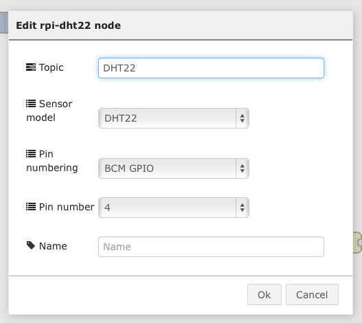
The key here was figuring out the settings for the DHT22 node, which required selecting BCM GPIO as the “pin numbering” scheme:
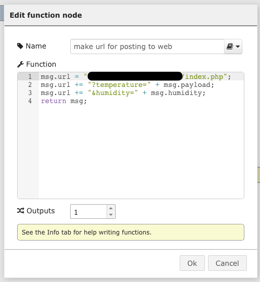
After that it was simple as running a functio node to make a URL for posting to my server:
and sending that to an HTTP Request node.
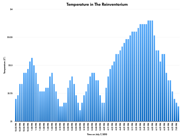
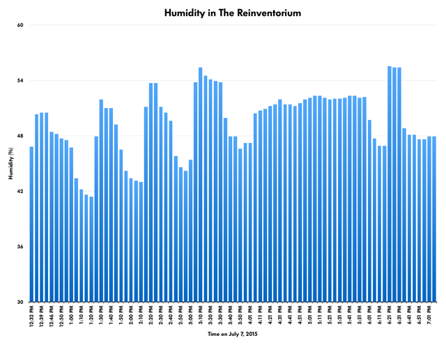
I fired things up and the data started to flow:
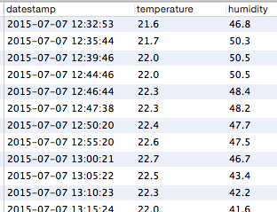
And from there I was able to export the data and make pretty charts:
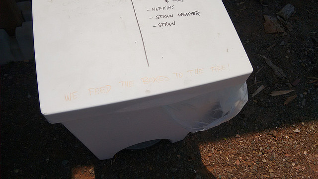
Remember how I mentioned that, here in Prince Edward Island, the ballot boxes from the Provincial General Election are burned in an incinerator that, in part, generates the heat for Province House where MLAs elected in those elections meet?
Well out at The Fifth Ingredient in Cape Traverse they take the pizza boxes they’ve just served you your pizza in and burn them in the oven. To make more pizza.
I was taking the bus by Enterprise car rental on University Avenue a few weeks ago when I spotted a Fiat 500 in the lot. When I got back downtown I called them up to see if it was available, but it was committed; they did, however, promise to give me a call when one became available, and a week later, this past Friday, they did, indeed, give me a call in the early afternoon.
I immediately hopped on the bus north and about 45 minutes later I was bopping around town. I called up [[Catherine]] and arranged to head to the shore and soon thereafter we were motoring north toward Stanhope for an afternoon of trendy European fun.
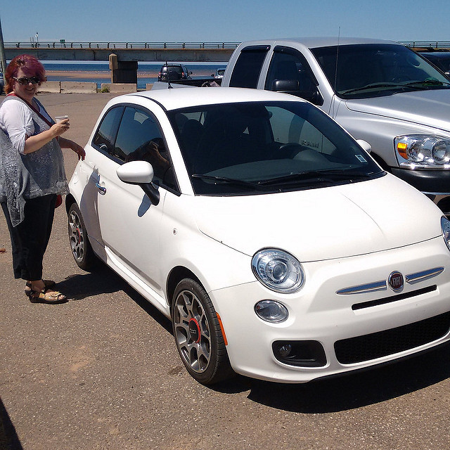
We’d rented the long station wagony version of the Fiat 500 last year for a trip to Maine, the Fiat 500 L, and it was a nice car. But the tiny original model is a completely different beast: it’s the smallest car I’ve ever drive (save for a test drive of a Smart Car), and yet inside it was roomy (at least for 2 people) and it drove like a nimble spitfire.
My favourite part of the car’s design is its centre console instrument cluster, which is wonder of compact design:
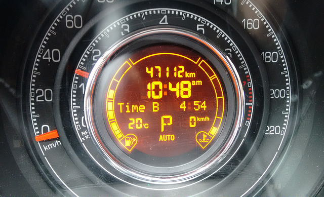
Packed in there are the speedometer (outside ring), tachometer (inside ring), odometer, time, temperature, digital speedometer, fuel level and engine temperature, the gear the engine’s in (P for Park on this display) and – the “Time B” line – a line of text that can be toggled among things like the current trip’s time and the current track playing on the radio.
I much prefer this to the ubiquitous touchscreen displays mid-console that every rental car I’ve driven in the past few years has been afflicted with.
We had the car for the weekend, so after Catherine and I motored out to the beach and back on Friday, [[Oliver]] and I went up to Souris and back on Saturday: it proved a perfect car for a father, son & dog trip.
I drove 315 km in total, and put about $25 of gas into the car on the way back to Enterprise, meaning that the gas mileage was about 35 MPG or 6.67 litres/100 km.
It’s on my list of Things to See and Do on PEI, but it bears additional highlighting: the newly-opened Shore Market in Stanhope, next to Richard’s Seafood, is that kind of place you wish were just up the street from your cottage at the beach (assuming you have a cottage at the beach, which we don’t, but regardless).
They sell Receiver Coffee (both beans and to-go; the iced coffee is fantastic), milk, fruit and vegetables, breadworks bread, meat, beach supplies, band-aids, and the kinds of sundries1 that you need when you’re out of the city. And capers: big jars of good-looking capers, for $8.35.
They also sell beer and wine, through an anachronistic “you can buy beer and wine if you show a food receipt from Richard’s next door” scheme that’s not their fault (someday PEI will fully recover from temperance, won’t it?).
It’s all wrapped up in a tiny, perfect, whitewashed wharf-shack.
So you can get head out to the shore, have your lobster burger and fries at Richard’s, then grab and iced coffee next door before you head out for more adventures.
A couple of times a year I get an email from faraway friends or family that’s some variation of “my buddy Gregor is coming to PEI in a few weeks: what should he be sure to see and do?”
I’ve just had another one, and rather than responding privately, I’ll respond here so that others in the same pickle have a place to look (or a place to point).
The things listed below are limited selection that reflect my own particular tastes rather than being any attempt at being broad and universal (of particular note: I’ve left out a couple of places that I don’t want tourists gumming up).
These are the places I take people when they visit, the ones that are not “generic anywhere.”
Where to Eat
Charlottetown
- Thai Pad Food Truck – excellent Thai food beside a brew pub
- Himalayan Curry – tasty Indian food
- Dave’s Lobster – modern lobster rolls
- Phở Hưng – Vietnamese food served by the nicest people on the Island
- Mr. Sushi – our go-to sushi place
- Water-Prince Corner Shop – the best fish & chips
- Sirenella – house-made pasta; the aglio e olio is excellent
Outside of Charlottetown
- The Pearl – quite possibly the best place to eat on the Island; dear, but worth it
- Landmark Café – another contender for “the best place”
- PEI Preserve Company – unsweetened iced tea; raspberry pie
- Richard’s Fresh Seafood – fresh fish, stone’s throw from the beach in Stanhope; tell the National Park attendant “we’re going to Richard’s” and you won’t have to pay park fee
- The Fifth Ingredient – a French bakery in the (relative) wilderness; excellent bread, but also pizza and sandwiches and smoothies of note
- Sheltered Harbour Café – never had a bad meal here; my go-to place in Souris
- Blue Mussel Café – fresh fish; no fries; stellar location; friendly staff
Where to Drink Coffee
Charlottetown
- Casa Mia Café – my go-to breakfast place
- Receiver Coffee – house-roasted coffee brewed with love and wit
Outside of Charlottetown
- Samuels Coffee House – unexpected gem in Summerside; even after the “good coffee… in Summerside?” surprise wears off, the coffee is still good, the space is nice and the folks are friendly
- Shore Market – ice coffee & capers; near the beach; amazing; beside Richard’s in Stanhope (see above)
- Island Chocolates – Factory Coffee = coffee + chocolate; in Victoria-by-the-Sea near the Landmark (see above)
Where to Beach
- Blooming Point – a spectacular semi-officially-recognized beach with no facilities other than parking
- Stanhope – inside PEI National Park; most remarkable for easy access to good food and coffee (see above)
- Argyle Shore Provincial Park – a nice place to picnic; water is shallow and calm and warm
- Canoe Cove Beach – another warm, shallow south-shore beach
- Sally’s Beach – not north shore, not south shore; not near anything; one of my favourites
- Tea Hill Park – an unremarkable beach with lots of mosquitos; but it’s very close to Charlottetown
What to See and Do
Charlottetown
- City Cinema – an “art house” cinema in downtown Charlottetown. Tiny, friendly and air conditioned with an eclectic program.
- Confederation Centre Art Gallery – austere, air conditioned, quiet space right downtown; a good place to get away from the crazy tourism-drenched streets on busy days
Outside of Charlottetown
- Yankee Hill Pioneer Cemetery – the most beautiful cemetery you will ever visit
- MacAusland’s Woollen Mills – worth the drive up west: the most interesting factory you’ll ever visit; you will leave having purchased a blank, I promise
- McKenna Road – one of the Island’s “heritage roads”; best avoided after a rain; drive along a clay road under a canopy of trees; spectacular
- Brackley Drive-in Theatre – the Island’s only drive-in; in the woods (so bring repellent) near the shore; we go at least once a summer
- Gardens of Hope – walking trails through forest and gardens along the river; beside the PEI Preseve Company (see above); excellent if you need a calm oasis
- Dunes Studio Gallery – most interesting for the architecture and the views; be sure to visit the gardens behind
- Trailside Café and Inn – it’s a café and an inn, yes, but most notably it’s a tiny perfect music venue; you will not be disappointed if you see a show here (and do go early and have supper before; you’ll get a good seat and a good meal)
- Kingfisher Outdoors – kayaking for non-kayakers: they have the kayaks, paddles and life-jackets, they drive you up the Morell River and put you in, you lazily drift/paddle down-river for two hours
- PEI National Park at Greenwich – hiking for non-hikers: the walk from the parking lot, through the woods, over the boardwalk through the marsh and out on to beach will take you breath away; it’s my favourite walk on the Island
- Belfast Mini Mills – most interesting to the fibre-loving tourist, but I love the simple pluck of the enterprise
About This Blog
 I am Peter Rukavina and this is my blog. I am a writer, letterpress printer, and a curious person.
To learn more about me, read my /now, look at my bio, listen to audio I’ve posted, read presentations and speeches I’ve written, or get in touch (peter@rukavina.net is the quickest way).
I have been writing here since May 1999: you can explore the 25+ years of blog posts in the archive.
You can subscribe to an RSS feed of posts, an RSS feed of comments, or a podcast RSS feed that just contains audio posts. You can also receive a daily digests of posts by email.