
AOL reports that the Charlottetown Dairy Queen is the busiest Dairy Queen in the world. They don’t provide a source for this (old media!), so I’m wondering where they got their information and what measure they use to rank “busyness.” Thanks to A. for the pointer.
I’m not a customer of the National Bank, but they have an arrangement with the Credit Union that lets me use their ATMs without paying a service charge. So I was unduly excited when they got a replacement ATM this week. Here’s the before and after:
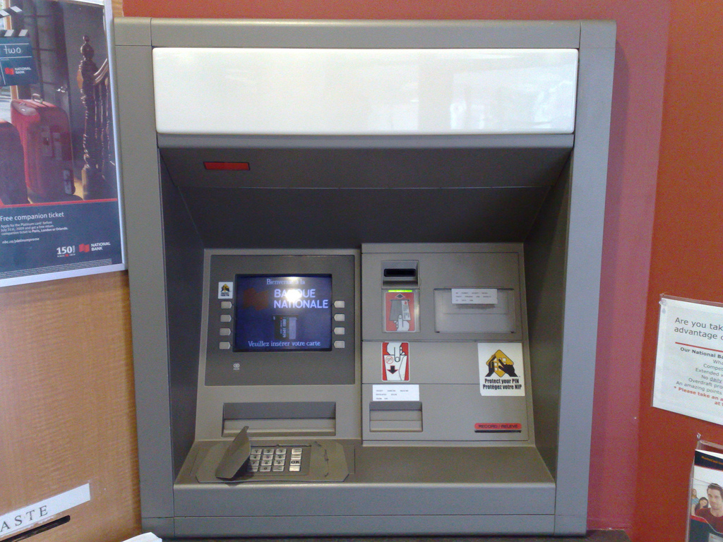
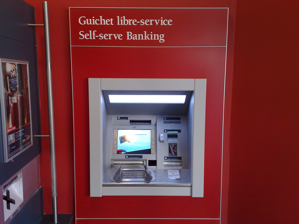
The new machine is a big improvement.
Walking directions from my house to the [[Charlottetown Farmers’ Market]]: Cloudmap vs. Google.
Because Cloudmade uses OpenStreetMap data, the Confederation Trail is there, so I get routed along a pleasant route rather than up University Avenue.
See also Cloudmade’s routing web service.
Tangent: it’s been over a year since I submitted a request to have the spelling of Rochford Square as Rockford Square corrected by Tele Atlas, which supplies map data to Google for Charlottetown. Still wrong.
Okay, here’s the missing link between the Visitors Guide Accommodations Search and the Tourism Inspection Reports: a bookmarklet that pops up the inspection report while you’re searching for accommodations in the Visitors Guide.
All you need to do is drag this link into your browser’s bookmark toolbar:
Then, when you’re looking at an accommodations listing — like this one, for example — just click on the bookmarklet and the inspection report should pop up in a new window. The “glue” between the Visitors Guide listings and the inspection reports isn’t perfect — there’s no unique ID to tie the two together, so I’m relying on a match of the names, which are sometimes different. But it seems to work most of the time. I welcome feedback.
You know those PEI accommodations inspections that Pat Martel told us all about this morning? I munged them all together — at least the 631 of them that had attached PDF files — into one big PDF file (warning: 124 MB) for your reading enjoyment. Consider it the sort of “visitors guide for people concerned about smoke alarms.”
Oh, and if you need to tell someone how to go to the actual web page where they appear, send them to bit.ly/inspections.
My friend Elmine made a short film about the next 2009 conference in Hamburg earlier this month. The next conference looks like reboot, but with better-dressed people.
Here’s a story about Don Sutherland.
Three years ago I hacked together a little project to create an RSS feed of applications under the Lands Protection Act. The Act is administered by the Island Regulatory and Appeals Commission and my hack scraped data from their website and reformatted in a form that made it easy to get automatically alerted to new applications.
As with many such projects of mine, there was a more than a small dose of “hey, you guys should be doing this kind of thing” moral suasion attached to this, an approach that usually fails abjectly to achieve its desired result.
Except that the person administering the IRAC website was Don Sutherland, and when I sent him a “hey, you guys should be doing this kind of thing” email his response was, two months later, to make the RSS feeds available directly from the source.
Now this may not seem particularly remarkable, but it was. Being a public servant is hard, and one of the things that makes it hard is the complicated dance required to serve the public, the public good, and ones political masters, each with their often competing impulses. A side effect of this complicated dance is that it’s rare the public servant who will accept feedback from outside institutional walls (especially cocky “moral suasion”-type feedback), see merit in it, and act.
This project was but one example of many over the last decade where Don manifested this openness. We were colleagues, of a sort, when I was working with Government on its own website, and we cooperated on projects several times under that umbrella. And, once I left that project, from time to time I would send him obscure questions about things like gas pricing data and he always responded with uncommon attention and detail.
Don Sutherland died tragically over the weekend, and in addition to the tremendous loss for his family and friends, we the people are worse off for his death, for we’ve lost one of those rare public servants who was able to dance that complicated dance expertly, and truly serve the public. He will be missed.
On Thursday morning a tweet came my way from Kerry Campbell, [[Island Morning]] morning staffer and sometimes-host, throwing down the geek gauntlet:
Peter, we need you to create a website that allows us to track the location of lobster vendors in real-time. I know you can do it.
Rather than mystically incanting such a site into existence, instead thought it better to show Kerry how to create such a tool himself: a Google Maps-based custom map that can be updated by anyone, making it a sort of “wikilobsteria” — a collaboratively edited map that can be co-created by Kerry and his listeners and, presumably, by lobster fishers themselves.
What you’ll need to do this…
- A computer with an Internet connection (preferably a fast one) and a web browser.
- Basic familiarity with Google Maps: how to move and zoom the map to different locations.
- Knowledge of how to “cut and paste” text on your computer.
- A collaborative spirit.
You can click on any of the screen shots below to see a more readable full-sized version.
1. Get a Google Account
You may already have a Google Account, but it’s easy to get one if you don’t: just go to https://www.google.com/accounts/NewAccount and fill out the form you find there, taking note of the account name and password you create for yourself.
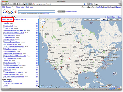
2. Go to Google Maps and Sign In
Go to Google Maps (http://maps.google.com/) and sign in (click on the “Sign In” link in the top-right corner) if you’re not already signed in to your Google Account. Then click on the My Maps link:
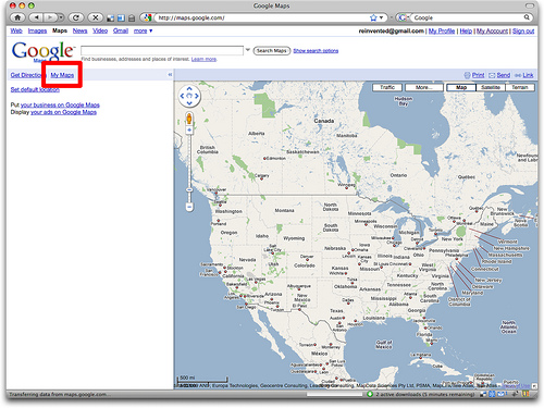
If you’ve created Google Maps before (like I have in this example), you’ll see a list of the maps you created earlier; if you haven’t, this area will be empty.
3. Create a New Map
Click on the Create new map link to create a brand new map:
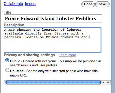
4. Enter a Title and Description
Enter a title and description for your new map. Remember that this is the text that people looking for your map will be searching, so be as descriptive as possible. Make sure you mark your map Public - Shared with everyone so that anyone will be able to see it:
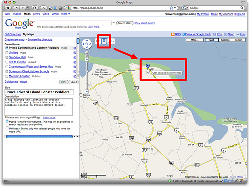
5. Start Adding Markers
Zoom and pan your map window (just like you would with a regular everyday Google Map) to the area where you’re going to start adding markers — i.e. locations where lobster peddlers are located. When you’re in the right area, click on the “marker” icon in the top-left corner of the map (it’s a blue teardrop shape) and then drag your mouse to move the marker to the location you want to mark.
Click the mouse to drop the marker in place and you’ll be prompted to add a title and description for the marker; again, be as descriptive as possible:
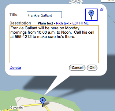
Click OK to save your new marker, or Delete if you’ve made a mistake and want to start again. Simply repeat the process for each location on the map you want to mark.
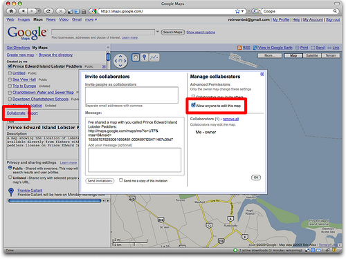
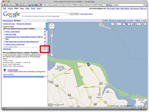
6. Turn on Collaboration
Because you want anyone to be able to edit the map, you need to turn on “collaboration” for the map. Click on the Collaborate link just above the map description and check the Allow anyone to edit this map box and click OK:
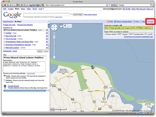
7. Save and Get a Link
Once you’re done adding markers to your map and are ready to save it and unleash the world on it, click the Save button and then the Done button, and then the Link link in the top-right corner of the map. Next, copy-and-paste the web address from the “Paste link in email or IM” box into an email message, instant message or word processor (you’re going to need this link in the next step):
8. Create a Tiny URL
Because you’re likely going to want to share this address — perhaps say it over the radio — you need a shorter way of expressing it. Go to http://tinyurl.com and paste the link you copied from the map into the “Enter a long URL to make tiny” box, and type an easy-to-say word into the “Custom Alias” box — something like peilobster, for example:
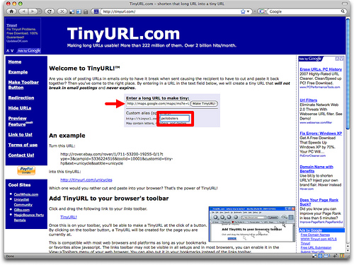
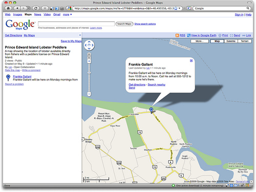
Click the Make TinyURL! button and you’ll have a brand new link — like http://tinyurl.com/peilobster in our example — that will lead to your map. People following the link will see something like this:
9. How Others Edit
Anyone else who has signed in with their Google Account will, in addition, see an Edit button on your map:
And anyone clicking on that Edit button will be able to add new markers, delete or edit existing markers, add comments to the map, and/or update its title or description.
10. How to Tell Others How to Edit
Here’s a suggested script for telling others how to collaborate on the map:
To see our map, just go to tiny u r l dot com slash p e i lobster. If you want to help make the map, click “Sign in” in the top-right corner, sign in to Google (or create a new Google Account). Once you’re signed in and back at the map, click the “Save to My Maps” link under the map and then Edit to add or update locations.
That’s it. And of course you can do this for any sort of map. I suppose you could even have an [[Island Morning]] “help us make the lobster map” contest if you wanted.
About This Blog
 I am Peter Rukavina and this is my blog. I am a writer, letterpress printer, and a curious person.
To learn more about me, read my /now, look at my bio, listen to audio I’ve posted, read presentations and speeches I’ve written, or get in touch (peter@rukavina.net is the quickest way).
I have been writing here since May 1999: you can explore the 25+ years of blog posts in the archive.
You can subscribe to an RSS feed of posts, an RSS feed of comments, or a podcast RSS feed that just contains audio posts. You can also receive a daily digests of posts by email.