The summer quickly draining away, [[Oliver]] and I decided to head out for a full day of Island adventures on Saturday; here’s the route we took, a nice loop around the edges of Queens County:
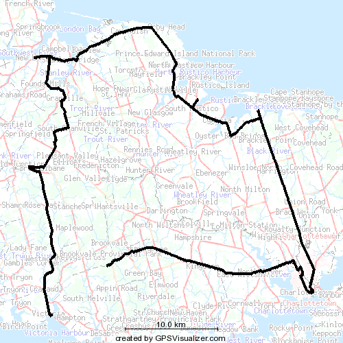
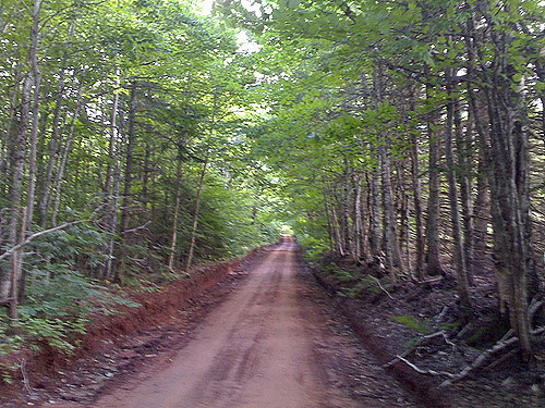 We started the morning with our usual stop at the [[Charlottetown Farmer’s Market]]. We then headed west on the Trans-Canada Highway over the causeway to North River, took a right at the traffic lights and then an immediate left out the Kingston Road. We passed by our old house in Kingston — now painted green — and eventually came to the turn-off after Emyvale that takes you down the hill to the left, then up the hill and on to one the Island’s “scenic heritage roads” — my favourite of the bunch, I think.
This network of old unpaved routes is something that no visitor to the Island should miss. They’re all clearly marked on the provincial highway map, and if you’ve got a car with good clearance, and aren’t intimidated by the odd muddy bit, you’ll be rewarded with some of the best rural agricultural scenery you’ll see anywhere.
Our GPS receiver cut out just after the turn off for the Appin Road — the road gets really covered leaves on the trees on either side at the point — but we continued along through the hills near Kelly’s Cross, and eventually emerged onto the Trans-Canada again at Hampton, where we then drove straight on in to the village of Victoria.
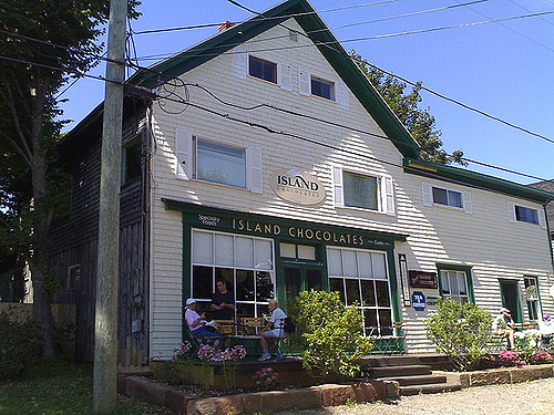 In Victoria we stopped at Island Chocolates for an excellent iced mocha coffee (for me) and hot chocolate (for Oliver). We saved room for a couple of their excellent chocolates as well. Victoria is a wonderful village, and Island Chocolates is at its heart; another “must visit” if you’re on the south shore. We rounded out our visit to Victoria with a climb up to the top of the village’s lighthouse — admission by donation, and the stairs are really steep — and a visit to the musty yet somehow endearing bookstore.
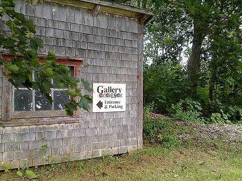 Back into the car we cut right across the Island, through Rose Valley, Breadalbane, and South Granville, emerging on the north shore just east of New London. In New London we paid our first visit to the Aubrey Bell Antiques Superdome (aka Gallery 18). Aubrey has taken his small downtown Charlottetown shop and expanded it into a great old barn; in addition to the maps, prints, posters and books he’s been selling all along, he’s added a good cross-section of paintings by Island artists. The barn is surrounded by a large collection of tiny outbuildings; while the Grand Plan is to have these all let our, right now there’s only one in use right now: expatriate Californian potter Karin Melzer has set up business as Bloomster, and is selling an interesting array of her own work.
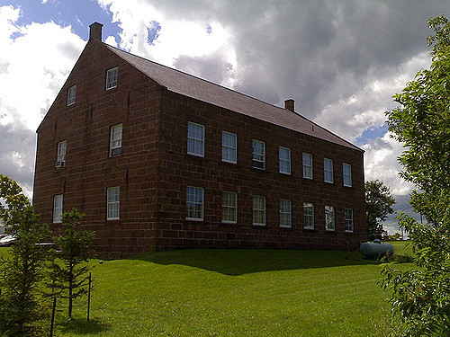 East from New London we drove through the insanity of Cavendish without stopping and along the north shore through North Rustico, and finally to South Rustico where we stopped to tour the newly-renovated Farmer’s Bank. The building itself is the real highlight: it’s simple, somewhat austere, and built out of Island sandstone; it’s arguably one of the nicest buildings in the province. Inside is a fairly mundane review of north shore Acadian history; there are a couple of interesting artifacts, but it’s not exactly a historical thrill-ride, and there’s nothing of particular interest to kids, so we made a quick tour.
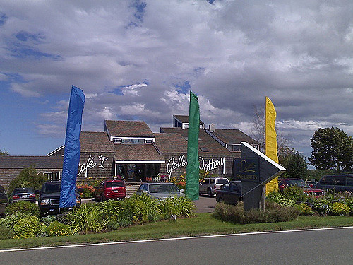 Back into the car, we headed east to Brackley Beach where we spent a couple of hours at The Dunes. We started with an excellent lunch: real iced tea (kudos) followed by crab cakes and salad. Very tasty, and the service was excellent. We then toured the sculpture garden and ponds in the back (Oliver’s shares his grandfather’s appreciation for Buddha sculptures), the stunning new furniture wing, and then took the Joey Tobin staircase for the panoramic view of the bay.
It’s impossible to describe what a fantastic place The Dunes is; it’s an excellent tonic whenever the “country floral” nature of the predominant Island aesthetic gets to you. We enjoyed our lunch and visit so much we took Catherine back for lunch on Sunday.
We rolled down the Brackley Point Road to Charlottetown and were home by 4:30 p.m. It’s easy to forget how much fun and interesting there is on PEI in the summer; I’m glad that we remembered before the snow starts.
From Springwise.com comes a pointer to POINTWC, a privately run public washroom in Paris. For 1 EUR, Springwise reports that:
Customers are welcomed by smartly dressed bathroom attendants, who also sell items in the boutique WC’s boutique shop. Impulse buys vary from diapers to designer toilet-paper holders. Needless to say, the bathrooms look (and smell) impeccable, and are cleaned after every single use. Women are provided with a powder room — a ’21st century boudoir’ — which offers hotel-sized toiletries, ample mirrors and good lighting.
Last Thursday afternoon I was sitting here in my office working away when a couple of email messages from PayPal arrived in rapid succession: both were receipts for purchases that I didn’t actually make (one for a “prank SMS” service, another for a year’s worth of web hosting in Germany), and both were genuine PayPal email messages (I didn’t click on the links in the emails themselves: I went to PayPal’s website to verify that the money had actually left my PayPal account. It had).
At first — before the second message arrived — I thought that Oliver might have been using the computer at home, that I’d mistakenly had his web browser remember my PayPal username and password, and the Oliver had mistakenly purchased something. Once the second email arrived with notice of the second purchase, I realized that this was unlikely (reinforced by the realization that making complete PayPal purchase would be beyond Oliver’s capabilities click-wise).
So panic temporarily set in once I realized that someone had guessed my PayPal password and was making purchases with it. Visions of my bank account quickly draining away danced in my head.
So here’s what I did.
First, I logged into PayPal again, confirming that I was actually connected to PayPal itself and not some phishing site by examining the URL (it did, indeed, start with https://www.paypal.com/).
Second, I immediately changed my PayPal password. Because doing this requires that having the original credit card that I used to register the account, I assumed the evil hacker wouldn’t have this information, and would be unable to change the password themselves. Nor to access my account once the password was changed.
Third, I went to PayPal’s “Resolution Center” and opened a new case to dispute the two purchases, providing all the details of the purchases and the original PayPal transaction numbers.
Finally, I visited the websites where the original fraudulent purchases had been made and sent email to their customer service contact addresses outlining what had happened and asking them to immediately cancel the purchases.
Now here’s the time for my mea culpa: I’m partly to blame for all this. Against all logic (and against everything I preach to others about password security) my PayPal password was both easy to guess — it was a combination of two English-language words both of which you’d find in a dictionary — and one that I’d used promiscuously on other consumer websites with the same username I’d used on PayPal.
Why was I so careless? Because I was lazy. I’d set up my PayPal account a long time ago when the world was a simpler place, and despite telling myself that I should update my password, I never got around to it.
So my next step, after dealing with the immediate PayPal crisis, was to ferret out all the other sites where I’d used the same password (at least I had good records!) and immediately changed my password to something unique to each website and in each case involving lots of upper and lower case letters, punctuation marks and numbers.
I’m happy to report that both of the fraudulent transactions were reversed, with the cooperation of the websites involved, within 3 days (I got personal replies from both after I sent my inquiries assuring me that they would reverse the charges).
And I’m happy to have been kicked in the security ass over an issue involving a couple of hundred dollars, not a couple of thousand.
I continue to think of PayPal as an excellent service, and I’m keeping my PayPal account in place (with its new much-more-secure password). But, as they used to say in high school, “with freedom comes responsibility.” What’s your PayPal password?
After much fiddling, I found out what the Portuguese translation of the title of Anne of Green Gables is: Anne e a sua aldeia.
Just goes to show that library catalogues can be a useful general research tool: I found this information by searching the Lisbon Municipal Library catalogue for books by L.M. Montgomery.
What I found was a reference to a 1972 translation by Olinda Gomes Fernandes published by Civilização in Porto.
Now, can any of you smart librarians in the readership help me track down a copy that I can purchase?
(With that information in hand, by the way, I also found this Czech page that shows the translation in several other languages).
I received the following error message after trying to a “flexible dates” search for travel between Charlottetown and London on Travelocity:

This is a new feature [sic] of the Travelocity website: up until recently you could do flexible dates searches for overseas travel too, and in fact I used the capability to find our excellent $300US return fares from Boston to Ireland in the spring.
The flexible dates search didn’t always work perfectly — about 25% of the time you would go through the entire process only to receive, 4 screens later, an error message of the “KLM does not fly from Halifax to London” kind, even though said fare clearly appeared in the list of available options. But I’d rather have a broken version of this feature than no version at all.
I called Travelocity’s Canadian call centre to ask for information about this change, and was told that “due to certain airline restrictions” the feature has been removed, but that it might come back at some later date.
Expedia has a weird version of a flexible dates search available for selected city pairs only, and says that the fares it displays are “the best prices recently found by Expedia customers” which seems like a number-crunching cop-out. And, what’s more, it doesn’t display a range of available fares, regardless of specific travel dates, as Travelocity used to do — you have to select a departure and arrival date before you get any pricing.
Looks like this might be an industry-wide purge: looking at the top websites in Google for “flight reservations,” I see that while some airlines offer this on their own sites, no general purpose airline site has a flexible dates search feature. Interesting.
Update: Here’s a blog post on the change — the feature was disabled on July 16th, and is related (as everything eventually seems to be…) to fuel surcharges. And here’s another blog post that offers some possible alternatives to Travelocity that have variations on this feature.
After almost a decade of full dental health, I had to go along to the dentist this afternoon to get a cavity filled. And next week I go back for another one. Needless to say our house is aflutter with all sorts of “don’t you know how to brush your teeth” sarcasm at my expense.
Cavity filling has come a long way in the 30-odd years since I had my first one filled. First, cavities get filled with some sort of magic epoxy that cures in 40 seconds under ultraviolet light. Second, there’s cable TV in the ceiling (and thus I’ve been fully briefed by CNN on the Mel Gibson situation). Third, my dentist is a friend, not a strange man with funny glasses. There also appear to have been several positive developments on the “freezing with a needle” front, such that all “this is going to pinch” warnings I received actually did pinch, and there were no episodes at all of jarring discomfort.
Well, besides the occasional mild episode of “I believe that I will be unable to breath or swallow sometime in the next minute and will make a fool of myself by flopping around and passing out right here in the dental chair.” Fortunately, this didn’t actually happen.
I arrived in Cornwall at 3:00 p.m.; I was out the door with cavity filled and paid for ($171) at 4:09.
My friend Don the Dentists’s parting words were “don’t bite your cheek.” Apparently my cheek is still frozen, and there’s some chance that were I to eat the wrong way, I might actually eat my cheek off without knowing it. Or something like that.
To avoid total paranoid meltdown, I’m going to avoid eating altogether for the next 12 hours. I need my cheek for other purposes.
If you have a Mac running OS X you may have noticed that considerably more spam is getting through Mail.app’s junk filtering, mostly a particular type of spam. Hawk Wings has a possible fix for this problem. I haven’t tried it yet. There’s good additional information in the comments for that post.
There’s a new brand of iced tea in down — UrbanZen-brand iced tea has replaced Honest Tea in the “health food” section of Shoppers Drug Mart on University Avenue. Their ginger flavoured tea is excellent, the lemon is an acquired taste, but is very refreshing, and the honey jasmine in almost undrinkable (it may also be an acquired taste, but one that I cannot acquire).
As with their handling of Honest Tea, Shoppers Drug Mart can’t seem to stock a regular supply of UrbanZen, so you’re just as likely to find them without stock as with; if you’ve a taste for ginger and iced tea, however, I suggest you invest $2.99 in a bottle of the ginger brand (yes, it’s $2.99 a bottle, which is expensive; worth it for the ginger, however).
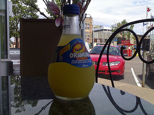 I stopped by the PEI Preserve Company Café on Queen St. for lunch this afternoon (wasn’t there supposed to be a contest to name their restaurant?) and found, to my surprise, that they’re carrying Orangina, a carbonated citrus drink from France. I had something of an addiction to Orangina back in the late 1980s in [[Peterborough]] that culminated in ordering a case of 1 litre bottles and a subsequent overdose that kept me Orangina free for the longest time. I ordered one for lunch today, however, and it was quite refreshing.
It won’t be long before the carbonated beverage cops crack down, I imagine, so if you’ve a hankering for one get it now. Remember what happened with the Jones Soda fiasco.
I spotted this sign this afternoon; it’s newly up on the site of the old Central Farmer’s Cooperative on Richmond Street:

My only exposure to developer Phillip O’Halloran was at a public meeting held several years ago to discuss the disposition of the old Charlottetown Forum lot after the building was demolished. Phillip presented what, by all appearances, was a very well-designed and appropriate plan for housing on that site; unfortunately the awesome power of Holland College to consume every square foot of that neighbourhood for parking meant that the plan was never brought to life.
Phillip has a good reputation as a savvy developer who understands neighbourhoods and design; certainly the look of the Richmond Street Condominiums on the sign suggests that he’s planning on putting up a well-proportioned building that’s somewhat more than the usual design-free box that typifies other recent housing developments in the city. I’m looking forward to seeing what emerges.
 I am
I am