
I want to find out what’s playing at the movies tonight in Charlottetown, so I surf on over to Empire Theatres’ website.
All I want to know is what’s playing. I don’t need to be convinced what to see, I don’t want to hold a birthday party, I don’t want a Subway breakfast sandwich. And yet look at their website:
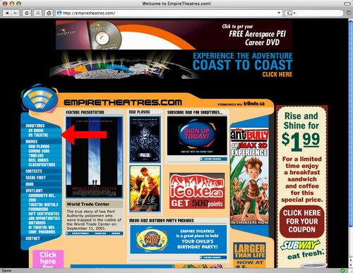
One of the smallest things on the page is the link to “showtimes by theatre” — but isn’t that what theatre websites are for? It gets worse: I click on “by theatre” and go to:
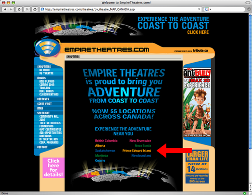
So here I get a jazzy Star Wars-style graphic telling me that I can go to Empire Theatres FROM COAST TO COAST. As I’m not considering going to the movies in Alberta tonight, this is of little relevance to me. I locate the link for Prince Edward Island and click, leading me to:
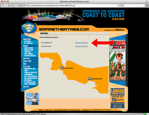
Note that on this page I can’t actually click on the icon placed on the map over Charlottetown, I have to click on “Empire Studio 8” (a name I have never heard uttered by anyone — there is, after all, only one multiplex in the city). Note how the “Empire Studio 8” is located several inches from Charlottetown, just to further confuse me. Finally I end up at:
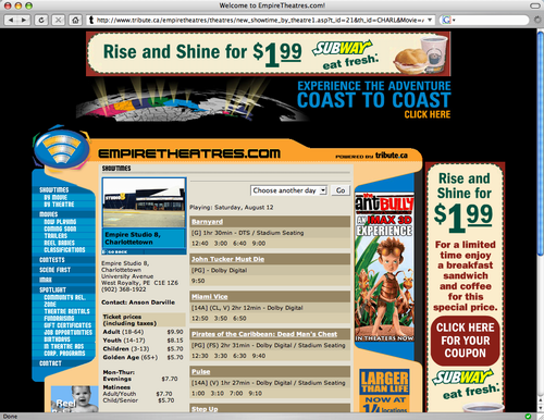
Finally, showtimes! And Subway sandwiches and Ant Bully ads. But that’s okay, I’ve got my showtimes now. The clever amongst you might be thinking “you should bookmark this page now so you can quickly return in the future.” Alas this isn’t possible: the URL for this page is inanely constructed so that it’s good for today only. There is no way to construct a hyperlink to the “Empire Studio 8” showtimes page; indeed attempting to make the URL “universal” by stripping off the date results in this unhelpful page:
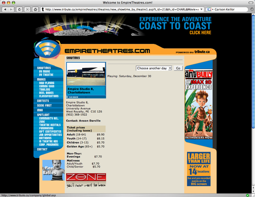
Not entirely useless, I suppose, as you can use it to plan your cinema outings for New Year’s Eve Eve.
I wonder whether anyone at Empire Theatres has ever actually tried to find out what’s playing at their theatres.
Disclaimer: I maintain the website for City Cinema, which is an Empire Theatres competitor. Indeed normally I’d be looking to go to movies there, but I just can’t abide Garrison Keillor tonight, or, actually, ever. I’ve always prided myself that finding out “what’s playing” at City Cinema takes no clicks at all.
A reminder that the Fundraising Concert for the L.M. Montgomery Land Trust is tomorrow afternoon, Sunday, August 13th at 3:00 p.m. at Avonlea in Cavendish. You can get tickets at the door.
G. and I went up to the Habitat for Humanity ReStore (an excellent resource for used building materials with profits going to a worthy cause) to pick up a chair he had acquired earlier in the day. On the way back downtown we stopped in at the new Shoppers Drug Mart on University Avenue — the one that occupies the space vacated by Pizza Hut.
Wow — it’s exactly the same as the other “new” Shoppers on University Avenue, the one that opened last year at the corner of Kirkwood Drive. It’s as if a giant fleet of trucks from the Shoppers plant pulled up one night and unloaded a pre-manufactured retail clone. Except that, for some reason, it took them months and months to construct. And the front door faces the other direction.
I’m not exactly sure why Charlottetown needs another giant Shoppers Drug Mart 4 miles from one with exactly the same layout and products. Is this a Shoppers vs. Ray Murphy fight to the death?
Speaking of things ablutionary: has anyone else noticed the sudden popularity of foaming hand soap? It’s everywhere these days, and seems to have come out of nowhere. In our house it started when we were sucked into the Kandoo frenzy, complete with its custom tailored soaps and bum-wipe dispensers for kids. I must admit, I’m a fan: there’s something magic about regular everyday liquid in a bottle being transformed into voluminous foam. A warning, however: don’t try to refill one of the special foaming soap dispensers with regular liquid hand soap: it won’t work, and you’ll be left with a door stop.
Elsewhere in the retail environment: I’ve decided to try to avoid shopping at Future Shop and Staples out in West Royalty in favour of using the Radio Shack (or whatever it’s called these days) downtown. Although their selection at Radio Shack is considerably less broad, they’ve got most of the electronic thingys a guy could have need for, the staff is surprisingly helpful and generous, and I think supporting a business that allows me to buy capacitors (should the need arise) that’s a block from my house is a Good Idea.
On Monday, at the invitation of Cynthia Dunsford, I attended a small gathering of “cycling people” at the Queen Street Commons to have introductory discussions about the possibility of forming a “bicycle users group” here in Charlottetown.
We had a good group of people, from hard-core cyclists to “3 blocks home and back” people like me, and people from both of the city’s cycle shops. There was also a reporter and camera operator from Compass and a radio reporter from SRC, all there to observe the proceedings. The discussion was focused and positive and there were an unusual number of practical ideas bounced around. We talked about bike lanes and bike racks and bike helmets, about how we ride bicycles in the city and what the challenges are, and about how to best proceed from here to advocate for a better cycling environment.
The session was mostly “guided brainstorming” and an opportunity for us to get to know each other and explore the possibility of working together.
At the end of the session we emerged with a tentative plan to get together with the City of Charlottetown in September to discuss the best way to work with the city.
At no point did we actually formally create a “bicycle users group,” and, happily, we spent no time at all talking about the usual organizational deadweight (bylaws, bank accounts, etc.). In other words we all left the meeting as we started it: a ragtag group of individuals affiliated only by our interest in the cycling issue.
So what did the CBC report? BUG wants bike lanes in Charlottetown, a story that starts:
The Charlottetown Bike Users Group (BUG) is lobbying the city to give it room on the streets. It is asking for designated bike lanes along the main traffic arteries of the capital. BUG spokesman P.J. Stephen said sharing the road with motorists who show no respect for cyclists bugs him.
BUG spokesman?! How can a group that doesn’t exist have a spokesman? Or a name? Or a lobbying effort? Apparently, according to the CBC, “BUG is also looking for more bicycle parking” and “said it doesn’t need fancy bike racks.”
I can’t conceive how a reporter in the same room as I was, for the duration of the meeting, could leave with the impression that somehow a formal organization had been created, a lobbying effort launched, and official positions taken. How did an informal “verb” get reportorially conjured into a formal “noun” without our knowledge? It just didn’t happen the way it was reported.
We’re having the outside of our house worked on this week — renewed trim and a new paint job — and this morning the work starting on removing the pieces of old rotten trim on the corner of the house right outside where our bed lies. So at 8:00 a.m. I was awoken by the sounds of saws and hammers and screeching trim.
As such I had a rare opportunity to listen to Island Morning on the radio, and I heard Karen Mair remind we listeners that the Charlottetown Farmer’s Market is open on Wednesdays. So around about lunch time, I heard Karen’s voice in my head, urging me on marketwise to eat.
Which is how I found myself, just before noon, on the bike, up University Ave. to Allen St. along Allen to the Confederation Trail and up the trail to the market.
Wednesday at the market is very different than Saturday: only about 1/2 the vendors, and about a quarter of the customers. So it’s claustrophobia-free with a smaller selection of food (tangent: can we stop using the term “ethnic food” to describe food that is not hamburgers and french fries — it doesn’t make sense in today’s Canada, where “regular” food is as likely to be chapati as it is french toast).
The altered food landscape caused me to depart from regular patterns, and so in addition to turning to Karin LaRonde for refreshing iced tea, I also ordered a bowl of her “oodles of noodles.” While I’m general averse to recipes that rhyme, this was a very good lunch: a bowl of noodles (oodles of them!) topped with stir fried vegetables and, at ones option, nuts and seeds and a tangy sauce.
Once I’d finished off my lunch (and returned my bowl to Karin as instructed — kudos to her for offering alternatives to styrofoam) I was going to head back to the office. But taking one last loop around I noticed that the Caledonia House Coffee booth had no line whatsoever in front of it — on Saturdays this never happens — and I took this as a sign that I should indulge in a rare cup of coffee (a piping hot mocha coffee, as it turned out).
I was fortunate at this point to run into Sandy and Dale and Riley and Bailey (and dog Cocoa) outside on a picnic table, and so passed a very pleasant half hour chatting with them before resuming my path back downtown.
So let this be a lesson to us all: when Karen Mair points the way, we should follow. Good food and good conversation (along with a sudden rush of caffeine) are apt to result.
Wikipedia has an interesting article on vehicular cycling:
Vehicular cycling (VC) is the practice of driving bicycles on public roads in a manner which is visible, predictable, and in accordance with the rules of the road for operating a vehicle.
The article makes the distinction between this and pedestrian cycling:
An alternative to vehicular cycling is pedestrian cycling, or cycling according to the pedestrian rules of the road. This means riding on sidewalks, crosswalks and paths at pedestrian speeds.
This afternoon it was back for week two with Don the Dentist (week one here) — this time to fill a cavity on the bottom, stage right. According to Don this is a “trickier” area of the mouth to deal in with more possibility of pain. From my side of the drill the most obvious side-effect of the location, at least at this hour, is that the nerves that get “frozen” for lower-mouth work also affect the tongue. So, 45 minutes out, the entire bottom right quadrant of my face feels numb, and I’m hoping that I don’t get one of those “hey, would you like to design a website for us for $1 million?” calls this afternoon as I’ll be unable to answer it with anything resembling normal speech.
I’ve discovered that at the heart of Don’s chair-side manner is to “over-promise and under-deliver” on the pinching, smarting, grinding front. In other words his “this will pinch quite a lot” never actually does. So waves of relief chemicals flood your brain, and everything is okay. So while I can’t say that I exactly enjoyed back to back cavity fillings (if we enjoyed it, we’d never brush our teeth…), I was far less terrifying — indeed not terrifying at all — than conventional wisdom would have you believe.
There being no Mel Gibson controversy for CNN to cover this week, I was left to watch blow-by-blow coverage of the recall of an American Airlines flight en route from London to Boston because someone on the “watch list” had been allowed to board by mistake. And bits of One Life to Live.
Apparently the decay in today’s tooth was more serious that the X-ray showed, so Don had to go in much deeper than he expected. So in addition to last week’s “don’t bite your cheek” and today’s “don’t bite your tongue,” I got an extra “this will probably hurt in an hour or two.” I’m hoping he’s over-promised on that too.
The summer quickly draining away, Oliver and I decided to head out for a full day of Island adventures on Saturday; here’s the route we took, a nice loop around the edges of Queens County:
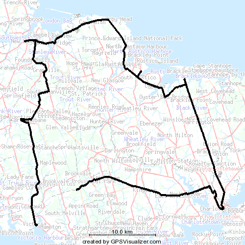
 We started the morning with our usual stop at the Charlottetown Farmer’s Market. We then headed west on the Trans-Canada Highway over the causeway to North River, took a right at the traffic lights and then an immediate left out the Kingston Road. We passed by our old house in Kingston — now painted green — and eventually came to the turn-off after Emyvale that takes you down the hill to the left, then up the hill and on to one the Island’s “scenic heritage roads” — my favourite of the bunch, I think.
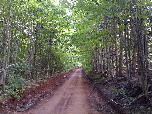
This network of old unpaved routes is something that no visitor to the Island should miss. They’re all clearly marked on the provincial highway map, and if you’ve got a car with good clearance, and aren’t intimidated by the odd muddy bit, you’ll be rewarded with some of the best rural agricultural scenery you’ll see anywhere.
Our GPS receiver cut out just after the turn off for the Appin Road — the road gets really covered leaves on the trees on either side at the point — but we continued along through the hills near Kelly’s Cross, and eventually emerged onto the Trans-Canada again at Hampton, where we then drove straight on in to the village of Victoria.
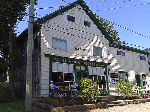 In Victoria we stopped at Island Chocolates for an excellent iced mocha coffee (for me) and hot chocolate (for Oliver). We saved room for a couple of their excellent chocolates as well. Victoria is a wonderful village, and Island Chocolates is at its heart; another “must visit” if you’re on the south shore. We rounded out our visit to Victoria with a climb up to the top of the village’s lighthouse — admission by donation, and the stairs are really steep — and a visit to the musty yet somehow endearing bookstore.
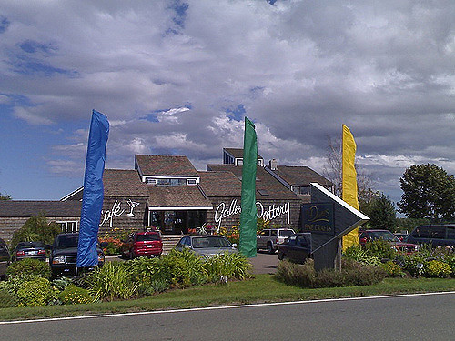
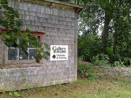 Back into the car we cut right across the Island, through Rose Valley, Breadalbane, and South Granville, emerging on the north shore just east of New London. In New London we paid our first visit to the Aubrey Bell Antiques Superdome (aka Gallery 18). Aubrey has taken his small downtown Charlottetown shop and expanded it into a great old barn; in addition to the maps, prints, posters and books he’s been selling all along, he’s added a good cross-section of paintings by Island artists. The barn is surrounded by a large collection of tiny outbuildings; while the Grand Plan is to have these all let our, right now there’s only one in use right now: expatriate Californian potter Karin Melzer has set up business as Bloomster, and is selling an interesting array of her own work.
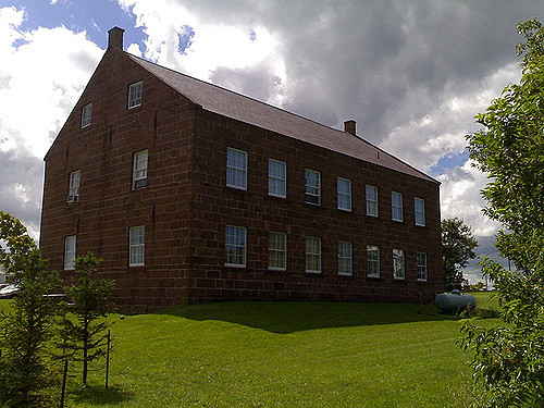 East from New London we drove through the insanity of Cavendish without stopping and along the north shore through North Rustico, and finally to South Rustico where we stopped to tour the newly-renovated Farmer’s Bank. The building itself is the real highlight: it’s simple, somewhat austere, and built out of Island sandstone; it’s arguably one of the nicest buildings in the province. Inside is a fairly mundane review of north shore Acadian history; there are a couple of interesting artifacts, but it’s not exactly a historical thrill-ride, and there’s nothing of particular interest to kids, so we made a quick tour.
 Back into the car, we headed east to Brackley Beach where we spent a couple of hours at The Dunes. We started with an excellent lunch: real iced tea (kudos) followed by crab cakes and salad. Very tasty, and the service was excellent. We then toured the sculpture garden and ponds in the back (Oliver’s shares his grandfather’s appreciation for Buddha sculptures), the stunning new furniture wing, and then took the Joey Tobin staircase for the panoramic view of the bay.
It’s impossible to describe what a fantastic place The Dunes is; it’s an excellent tonic whenever the “country floral” nature of the predominant Island aesthetic gets to you. We enjoyed our lunch and visit so much we took Catherine back for lunch on Sunday.
We rolled down the Brackley Point Road to Charlottetown and were home by 4:30 p.m. It’s easy to forget how much fun and interesting there is on PEI in the summer; I’m glad that we remembered before the snow starts.
From Springwise.com comes a pointer to POINTWC, a privately run public washroom in Paris. For 1 EUR, Springwise reports that:
Customers are welcomed by smartly dressed bathroom attendants, who also sell items in the boutique WC’s boutique shop. Impulse buys vary from diapers to designer toilet-paper holders. Needless to say, the bathrooms look (and smell) impeccable, and are cleaned after every single use. Women are provided with a powder room — a ’21st century boudoir’ — which offers hotel-sized toiletries, ample mirrors and good lighting.
Last Thursday afternoon I was sitting here in my office working away when a couple of email messages from PayPal arrived in rapid succession: both were receipts for purchases that I didn’t actually make (one for a “prank SMS” service, another for a year’s worth of web hosting in Germany), and both were genuine PayPal email messages (I didn’t click on the links in the emails themselves: I went to PayPal’s website to verify that the money had actually left my PayPal account. It had).
At first — before the second message arrived — I thought that Oliver might have been using the computer at home, that I’d mistakenly had his web browser remember my PayPal username and password, and the Oliver had mistakenly purchased something. Once the second email arrived with notice of the second purchase, I realized that this was unlikely (reinforced by the realization that making complete PayPal purchase would be beyond Oliver’s capabilities click-wise).
So panic temporarily set in once I realized that someone had guessed my PayPal password and was making purchases with it. Visions of my bank account quickly draining away danced in my head.
So here’s what I did.
First, I logged into PayPal again, confirming that I was actually connected to PayPal itself and not some phishing site by examining the URL (it did, indeed, start with https://www.paypal.com/).
Second, I immediately changed my PayPal password. Because doing this requires that having the original credit card that I used to register the account, I assumed the evil hacker wouldn’t have this information, and would be unable to change the password themselves. Nor to access my account once the password was changed.
Third, I went to PayPal’s “Resolution Center” and opened a new case to dispute the two purchases, providing all the details of the purchases and the original PayPal transaction numbers.
Finally, I visited the websites where the original fraudulent purchases had been made and sent email to their customer service contact addresses outlining what had happened and asking them to immediately cancel the purchases.
Now here’s the time for my mea culpa: I’m partly to blame for all this. Against all logic (and against everything I preach to others about password security) my PayPal password was both easy to guess — it was a combination of two English-language words both of which you’d find in a dictionary — and one that I’d used promiscuously on other consumer websites with the same username I’d used on PayPal.
Why was I so careless? Because I was lazy. I’d set up my PayPal account a long time ago when the world was a simpler place, and despite telling myself that I should update my password, I never got around to it.
So my next step, after dealing with the immediate PayPal crisis, was to ferret out all the other sites where I’d used the same password (at least I had good records!) and immediately changed my password to something unique to each website and in each case involving lots of upper and lower case letters, punctuation marks and numbers.
I’m happy to report that both of the fraudulent transactions were reversed, with the cooperation of the websites involved, within 3 days (I got personal replies from both after I sent my inquiries assuring me that they would reverse the charges).
And I’m happy to have been kicked in the security ass over an issue involving a couple of hundred dollars, not a couple of thousand.
I continue to think of PayPal as an excellent service, and I’m keeping my PayPal account in place (with its new much-more-secure password). But, as they used to say in high school, “with freedom comes responsibility.” What’s your PayPal password?
About This Blog
 I am Peter Rukavina and this is my blog. I am a writer, letterpress printer, and a curious person.
To learn more about me, read my /now, look at my bio, listen to audio I’ve posted, read presentations and speeches I’ve written, or get in touch (peter@rukavina.net is the quickest way).
I have been writing here since May 1999: you can explore the 25+ years of blog posts in the archive.
You can subscribe to an RSS feed of posts, an RSS feed of comments, or a podcast RSS feed that just contains audio posts. You can also receive a daily digests of posts by email.