
 One of my favourite events is the somewhat-annual CBC Prince Edward Island Open House, where the local CBC facility here in Charlottetown throws its door open and lets we in the listenership meet the bodies behind the voices, try on Boomer’s Hawaiian shirts, make our own radio documentaries, run the robotic cameras and eat baklava. Or something like that.
This year’s edition is happening on November 29, 2008 from 10:00 a.m. to 1:00 p.m.. Which hardly seems enough time to get the thousands of people through the doors (really: there were super-long lines last time). But, regardless, it’s well worth a visit if you haven’t before.
When I first landed on Prince Edward Island almost fifteen years ago, one of the first places I went was to the Computer Services department at the University of PEI. At the time UPEI was running a pilot project to provide dial-up Internet access to Islanders, and anyone who asked could sign up. Which is how I became caprukav@atlas.cs.upei.ca.
This project was revolutionary: it got the Internet to Prince Edward Island well before the days of a market for Internet, and a lot of what’s happened on the Internet here on the Island can be traced back to people who were involved, as users or organizers, in that project.
Which is why it’s unfortunate that the same “Internet for the people” ethic doesn’t apply to the provision of wireless access on the UPEI campus.
Visiting UPEI this morning I fired up my wifi-enabled [[Nokia N95]] to find wireless infrastructure spread across much of the campus, with four SSIDs in evidence almost everywhere:
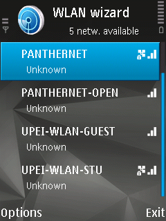
Unfortunately the two non-secured networks, named, ironically it would seem, “OPEN” and “GUEST,” both lead to a PantherNet Open Wireless Login screen:
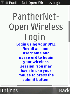
The network is locked down, and only students, faculty, and staff are permitted access.
This would be fine if you have a vision of the University as a walled institution with limited intrusions from outsiders.
However I prefer a model where UPEI is a centre of scholarship and resources for all, regardless of formal affiliation.
Making use of the resources of the University is considerably enhanced by having free and unfettered and anonymous access to the Internet, whether it be to find out when the next bus is leaving, to snap a photo of an article in the library for OCR and translation to a different language, to send and receive email, or any of the myriad other usefulnesses the network can provide to a curious person in an environment that should be seeking to embrace and extend curiousity in every way possible.
I know that there are issues of resources and bandwidth and the possibility of some anonymous pirate running a porn site from a weather-proof PC in the quadrangle. But all of these issues are ones that others have dealt with. There are best practises out there, and ways of making this work.
Can someone at UPEI make this happen, please.
The Charlottetown Transit system up and down University Avenue now runs every 30 minutes, which is often enough to graduate at least that route into “regular world” status: it’s often enough that you don’t need to make special plans to sync with the bus, as one will always be along in a reasonable amount of time.
I took the bus up to UPEI this morning for an Access 2009 planning meeting and got the rare opportunity to ride one of the special hydrogen-powered buses that are more often used in a back-up or special-purpose role:
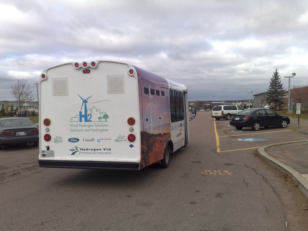
The hydrogen buses are a pilot project of the Governments of Canada and Prince Edward Island, along with Ford and Air Liquide, and they were announced a year ago this month.
While I can’t say anything bad about the ride itself — it seemed like a regular everyday bus ride in all respects — that this is a prototype that’s not ready for prime time was clear from the fact that the buses only hold 12 passengers: in the photo above the part of the bus with windows holds people; the large section at the back of the bus holds whatever hydrogen-powered magic that makes the buses go.
Unfortunately the hydrogen that powers the buses is being trucked in from off-Island, something that presumably reduces the clean ride aspect of the project; the plan is that eventually something like the Wind-Hydrogen Village project might generate the hydrogen, but this hasn’t happened yet.
A concerned family member writes, about my experiments with OpenStreetMap:
I don’t understand the point of this project. What would you contribute that isn’t already available in Google Maps?
The OpenStreetMap FAQ has an answer to this; it says, in part:
Most hackers around the world are familiar with the difference between “free as in beer” and “free as in speech”. Google Maps are free as in beer, not as in speech.
If your project’s mapping needs can be served simply by using the Google Maps API, all to the good. But that’s not true of every project. We need a free dataset which will enable programmers, social activists, cartographers and the like to fulfil their plans without being limited either by Google’s API or by their Terms of Service.
I would add that the notion of outsourcing something as integral to the public good as street maps to a corporation is irresponsible: maps are important enough that they should be owned by the commons, not by a corporation, however benevolent.
Equally important, and perhaps more interesting, than these intellectual property concerns, however, is that OpenStreetMap maps can be better than anything Google, Yahoo and Microsoft can offer. Here, for example, is snippet of the OpenStreetMap for Reykjavik, Iceland:
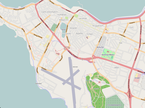
And here’s the Google Map of the same area (yes, it’s empty — Google has no map data for Reykjavik):

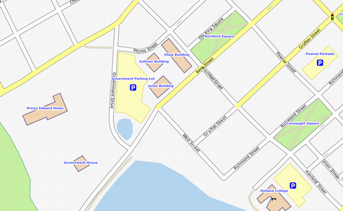
But this isn’t restricted to areas like Iceland where commercial maps companies don’t have any coverage, it’s true of anywhere that the OpenStreetMap has been locally enhanced. Here in Charlottetown, for example. Here’s the OpenStreetMap for an area of downtown Charlottetown:
Here’s the same area in Google Maps:
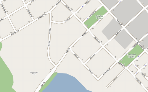
Not only is the OpenStreetMap more complete with more showing more detail, it’s also more accurate. Notice how Google shows Rochford Square as Rockford Square? I submitted a bug report to TeleAtlas on March 19, 2008 and the misspelling is still there.
Because OpenStreetMap can be enhanced by people who live in a community, drive the roads and walk the trails and pass the buildings every day, it has the potential not only to be the best map available, but also to take community mapping to a level of detail and utility that commercial companies will simply never be able to muster.
I’m considering organizing a free day of training and doing on OpenStreetMap for Charlottetown.
Likely on a Saturday or Sunday in late November or early December, the day would be designed for absolute beginners with an interest in learning how to contribute to the OpenStreetMap project: we’d cover the basics, and then spend the balance of the time doing actual mapping.
The “actual mapping” process can involve both going out into the field on foot or bicycle to gather GPS traces and staying indoors and tracing map features over satellite photos, so people with a wide variety of abilities, interests, and mobilities would be welcome. I’ve got a couple of co-conspirators who’ve agreed to help, but we could always use more.
If this is something you’d be interested in either helping to organize or attending, please leave a comment here.
In the almost 10 years that I’ve been writing in this space there’s always been a page for “posts” and a separate page for “comments” on those articles.
When I first cobbled together the application that allows me to write and you to read these pages, there were no “best practises” for how blogs should work other than the “show posts in reverse chronological order.” Since that time the world has decided that comments should appear at the end of posts. And so I figured it was probably time to catch up.
Starting today, thus, every post has a permalink, and on that single page you’ll find the post itself, followed by any comments, followed by a comment form where you can leave your own. This is neither revolutionary, nor particularly elegantly grafted together for the moment. But perhaps it will, by conforming to the de facto standard, make this space a little easier to digest.
Thanks go to Steven Garrity who first suggested that I move in this direction about five years ago. I am nothing if not slow to act.
Please let me know if you notice any inconsistencies in the comment-leaving and comment-reading process.
In her introduction to My Kind of Place: Travel Stories from a Woman Who’s Been Everywhere, author Susan Orlean writes about “travel writing in the new world that 9/11 seemed to have brought forth”:
Should anyone write about — or read about — what it’s like to snowshoe through Alaska or raft in Costa Rica when the world seemed to be falling apart? Would anyone in his or her right mind have any interest in leaving home when the universe seemed so threatening? What I said then, and still believe, is that human beings are stubbornly and persistently curious and that I can’t imagine we will ever lose our desire to know about what lies beyond our immediate horizon. At a time when the world feels chaotic and frightening, writers who go out to see it and describe it seem more important, not less. Even fluffy, expository stories about pretty places matter if people are less inclined to travel, since then the writer acts as the reader’s proxy, bringing back the world that most people might be reluctant to go out and see for themselves. At the most elemental level, the world’s troubles are the result of people turning inward and turning away from whatever and whoever is different and unfamiliar. If a writer can make even one reader feel more open to someone or someplace new, I think he or she has accomplished something well worth doing.
I think the same thing could be said about the version of trying times we seem to be entering now.
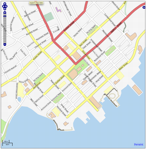
It’s been a while since I spent any time editing OpenStreetMap for Charlottetown, and the tools available for making edits have evolved considerably in the interim. So today I spent some time tweaking and enhancing the city; you can see the work in progress here:
If you’re interesting in community mapping and you haven’t taken a look at OpenStreetMap lately, I suggest you return to the fold.
I’ve just finished reading The Big Necessity: The Unmentionable World of Human Waste and Why It Matters, and it’s no exaggeration to say that it’s among the best books I’ve ever read. I’ll have more to say later, but for now just one sentence from the closing chapter (emphasis mine):
Water, water everywhere and none of it is infinite. Water is a fixed commodity. At any time in history, the planet contains about 332 million cubic miles of it. Most is salty. Only 2 percent is fresh water and two-thirds of that is unavailable for human use, locked in snow, ice and permafrost. We are using the same water that the dinosaurs drank, and the same water has to make ice creams in Pasadena and the morning frost in Paris. It is limited and it is being wasted.
Some smart feedback from the network on my Facebook + CBC post. First, an anonymous old friend writes:
It would be nice to see something easy and open-source like Facebook that people like my mom and that girl I went to high-school with could use. Perhaps you know of something? I’m glad to have access to the minutiae of your life out in the open. I wish more people outside of Facebook felt they had the skill or platform to do so.
The next message in my in-box was an unknowing response: [[Olle]] points to Indymedia and the Enclosure of the Internet, which says, in part:
Activists who would never consider eating meat or crossing a picket line think nothing of putting their entire communications infrastructure into the hands of Google, Yahoo, Microsoft, and Rupert Murdoch. There are enormous practical problems with respect to communications security, data ownership, privacy, censorship of content, and data mining by both corporations and law enforcement agencies. From what I can see everyone from the left-liberal NGOs and environmentalists, to the unions, and over into the extraparliamentary anarchist and communist groups all have the same attitude: there is no problem. Move along. Shut up about it, you’re being a geek.
We need to be explaining these issues to people in a consistent and effective way. Perhaps explaining that it’s like holding all your political meetings at McDonalds, and ensuring that the police come and film you while you do so, would be one approach to take.
About This Blog
 I am Peter Rukavina and this is my blog. I am a writer, letterpress printer, and a curious person.
To learn more about me, read my /now, look at my bio, listen to audio I’ve posted, read presentations and speeches I’ve written, or get in touch (peter@rukavina.net is the quickest way).
I have been writing here since May 1999: you can explore the 25+ years of blog posts in the archive.
You can subscribe to an RSS feed of posts, an RSS feed of comments, or a podcast RSS feed that just contains audio posts. You can also receive a daily digests of posts by email.