Here is a strand.

Eleven years ago I attended a public meeting at the Delta Prince Edward hotel where Maritime Electric, Prince Edward Island’s electric utility, made its case for a dramatic increase in electricity rates.

As I related at the time in this space, the key line of the evening, for me, came when CEO Jim Lea, responding to my question about whether there would ever be a situation where it would be beneficial for the company if electricity consumption were to drop, answered, with commendable honesty, “no it would not be beneficial.”

That simple realization drove home for me that it was never going to be the utility that was going to drive electricity reduction efforts: if anyone was going to do it, it was going to be we the people.

Also in the audience at that meeting was Richard Brown, a fellow resident of downtown Charlottetown, a fellow computer programmer, someone interested in energy issues, and, at the time, a defeated Liberal MLA.

Six months later, Richard was elected to the Legislative Assembly again, and joined the Liberal opposition for a term before being reelected in 2007 and joining Executive Council.

Two years later, in 2009, Richard was named Minister of Environment, Energy and Forestry and I interviewed him as a part of a series on climate change I was producing.

I returned to Richard’s office two years later, in March of 2011, to discuss the possibility of having information about electricity load and generation, including wind energy, released as open data, returning to the thread that started in 2003: if it was we the people that were going to responsible for reducing electricity consumption, we were going to need access to data about generation and consumption to arm ourselves.

By July, still without access to this data, I created a hack that used New Brunswick data to provide a slice of the energy picture and created another hack, covered by CBC Spark, that allowed the energy flow to be visualized through techno music.

A year later, in June of 2012, the project I’d originally discussed with Richard bore fruit, thanks to the efforts of his department of of the province’s IT department, and open data on energy load and generation started to flow and I started to archive it.

Someone who noticed my efforts was Scott Bateman, a researcher in human-computer interaction at the University of PEI (and a colleague from many years ago when we both worked on the provincial website project). Scott proposed that we work together on a project to create an in-home appliance – an “energy thingy,” he dubbed it – that would use that open data to present “actionable feedback” about electricity usage.  It might glow green when the wind was blowing and much of the electricity was being wind-generated, and glow red when the reverse was true. And thus help you decide when to turn on the clothes dryer.

Scott proposed the project to the NRC, it was funded, and now that “thingy” is a real thing: it has how-to manual, open source code, and you can build one yourself.

Meanwhile, I shifted my focus from the macro to the micro, applying for and being granted a City of Charlottetown micro-grant to fund The Social Consumption Project, a pilot effort to provide daily water and electricity consumption data to five households in Charlottetown.

All of which led to me spending this week in Calgary, in part with Scott’s academic colleagues in the Innovations in Visualization Laboratory at the University of Calgary, discussing both our “macro” and “micro” energy projects, with an eye to learning more about how their thinking in information visualization can be used to both improve the presentation of data and increase the likelihood of it spurring positive action.

We spent a very productive session with the team in the lab today, and already my head is filled with alternative approaches and interesting ideas: they are an insightful lot and, as I wrote the team afterwards, it was refreshing to discuss with interested others ideas that I had mostly, to this point, discussed only with myself.

Scott and I are presenting the “thingy” at the SurfNet conference later this week and I’m certain that we’ll find other opportunities for collaboration there.

I never could have imagined, when I attended a little meeting in a Charlottetown hotel, that I would end up, a decade later, pursuing the same strand, in a rich academic context.

This is the kind of thing I love doing – following stands, connecting dots, building digital connective tissue, meeting interesting people, following my curiousity.

Among other things, it has provided me with a route back into the academy after 30 years: I have finally found a way of engaging academia which, rather than being soul-dampening, as it was the first time around, is compelling in ways I never could have imagined.

Moral of the story: don’t be afraid to follow unlikely strands; they can lead you places you can’t get elsewhere.

Do stuff. Tell other people about it. Ask questions. Be patient. And see what happens.
🗓️
Musing  •  Travel

In Rukavina family lore my paternal grandmother Nettie is famous for the distance she would walk to save money. From her house on Mary Street in Brantford she would walk to a Callbeck’s grocery store far across town to save 45 cents on a tub of yogurt. And think nothing of it. She came of age in the Great Depression, and habits forged there she never broke. And these are habits she passed to my father, who, in turn, passed them to me, albeit with some withering away of the more extreme elements in each generation.

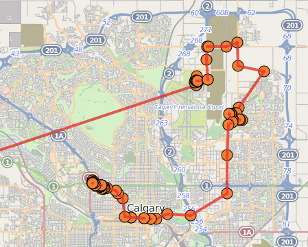
And so when it came time to find a way from Calgary International Airport to my hotel across town this afternoon, I wasn’t looking for the fastest or most elegant way of traveling, I was looking for the cheapest way.

I could have taken a taxi ($40-45, says the airport). Or an airport shuttle ($15). But my eye was immediately drawn to Calgary Transit, which could do even better.

Option number one, which would take about an hour, involved bus #300 and the light rail line and would cost $8.50.

Option number two would take about 90 minutes, via bus #100 and light rail, was only $3.00.

As you can probably imagine, I opted for the $3.00 solution.

Except that as I was standing in front of the ticket machine at the airport, the man at the machine beside me asked if I was looking for a ticket for the #100 bus, and when I told him that I was he offered me the one he’d just purchased, as he’d decided to take the quicker, more expensive route.

So I ended up getting to my hotel for free. Nettie, I hope, would have been proud.

From the placement and lack of signage pointing the way to public transit, it appears as though the airport hasn’t wholly embraced this transport option. The Calgary Transit information desk, for example, was staffed by someone who seemed completely unskilled at giving directions. And the desk is located at the opposite end of the airport from the bus departure bay, meaning that rather than following the signs for “ground transportation,” you actually go the opposite direction. Even the bus driver himself seemed to treat my presence grudgingly.

But, that all said, it worked: the bus #100 goes to the McKnight-Westwinds light rail station, and from there it was an easy train ride downtown, a quick transfer, and a ride out toward the University of Calgary on the other light rail line. 90 minutes after setting out, I was happily checking into my hotel.

Calgary Map showing my route from the airport to my hotel

🗓️
Travel  •  Calgary  •  History

Flight Notification SMSA curious set of circumstances will see me spending the next week in Calgary wearing two overlapping hats – Hacker in Residence and Reinvented – to engage in a rollicking good time amongst academics working in information visualization and surface computing, with an eye to developing collaborations around a number of projects, including the energy thingy that Scott Bateman has been developing for Reinvented, the Social Consumption Project that I’ve been funded by the City of Charlottetown to carry out, the Archiving Geopresence project that I’ve been working on for several years, and a variety of other projects and pipe dreams (including an idea that’s been floating around my head to someone illuminate the Samuel Holland township lot lines so that they can be seen from outer space: I’m pretty sure there’s a better approach than my “light a lot of bonfires” idea).

Two hats requires two business cards, so I’ve got the case packed with half of each. And which had I’m wearing at any given time – adventurous hacker or keen capitalist – will depend on the circumstance and my mood.

Business Cards Pile x 2

I’m taking the long way to get to Calgary, stopping in Toronto tonight, flying to Vancouver tomorrow and then immediately on to Calgary, and then, next Friday, flying back to Vancouver for a quick two-day stopover before arriving back in Charlottetown a week from Sunday.

Or at least that’s the plan: Air Canada has been sending me flight notifications all afternoon long moving the departure time for my flight to Toronto ahead. Projecting forward, at this rate I’ll likely be leaving after I come home.

🗓️
Calgary  •  Travel  •  Hacker in Residence

A couple of days ago I received an email from AVIS car rental that pointed me to a website where they informed me that they had billed me $23.00 for passing through a Massachusetts Turnpike toll plaza on July 16, 2014:

I was, in fact, in New England that week, on business with Yankee Publishing, and I did rent a car from AVIS, so that much is true.

But I wasn’t in Massachusetts on July 16, and I know this because, since May, I’ve been archiving my “personal geolocation” to my own server, and looking at where I was at on July 16 you can see that my travels were limited to a triangle of Peterborough, NH (where my hotel was), Dublin, NH (where Yankee is) and Hancock, NH (where I had supper with my colleagues on the Yankee web team):

Map of southern New Hampshire showing my location on July 16.

If my own geoarchiving wasn’t enough. Google is keeping track of me too (and with even more resolution), and Google Location History clearing shows me in Peterborough, NH at midnight, which would make it impossible for me to be in Massachusetts 9 minutes later:

Google Location History for July 16.

None of this would likely hold up in a law court, but it was enough for me to be able to report to AVIS with confidence that the charge was spurious. So I called AVIS, and explained the situation. They told me that their records indicate that the charge was based on a photograph of a license plate, and that it was likely a mis-read, especially because the toll receipt shows me exiting the turnpike, but not entering it.

Not since the great Plazes geolocation event of summer 2005, which introduced me to Ton and Martin has having a device in my pocket keeping track of where I am been so much fun.

🗓️
Car Rental  •  Geolocation  •  AVIS

Remember Robert P. Haythorne, the most interesting Prince Edward Island premier you’ve never heard of? Well a bunch of modern-day Islanders from Haythorne’s stomping grounds in Marshfield are seeking to rectify this under the banner of PEI2014.

On Saturday, October 4 (rain date is Sunday), starting with a 4km walk on “Senator Haythorne Lane” at 1:15 p.m. and continuing with formal festivities at 2:00 p.m., the memory of Haythorne will be feted in the style he richly deserves:

  • A talk by Jim Hornby, “Poore by Name – Rich by Nature.”
  • Signing of a petition to name the trail right-of-way in honour of Haythorne.
  • Musical entertainment and refreshments.

It’s all hosted by the Hillsborough River Association, the Marshfield Pioneer Cemetery Trust Fund and the Marshfield WI.

🗓️

Remember the Confederation Country Cabinet project that I made a small contribution to this spring?

Well I was delighted to receive a copy of the book that Brenda Whiteway arranged to have produced by the talented Judy Gaudet that details the genesis and execution of the cabinet. As someone whose head was deep inside the project for many months, the greatest role the book plays is allowing me insight to the other artists who were busy making their contributions at the same time.

Like Joe McAskill, the woodworker who brought the cabinet itself to life:

The Cabinet (snippet of book)

And Brenda herself, who not only spun flax into linen, but who actually grew the flax herself:

Brenda (snipped from book)

There’s a story about each of the potters who crafted drinking vessels – one per Father of Confederation – along with a photo of each:

Some of the potters (snippet from book)

And an embarrassing number of photos of me at the printing press:

Me at the press (snippet from book)

The book is available for purchase online and you can also preview the entire thing there in its full-colour 30 page glory. Because it’s a “print on demand” project, there are absolutely no economies of scale to the printing, so it’s not an inexpensive tract. But as a result you can order it in any of hardcover, hardcover with dust jacket or soft cover.

🗓️

Here’s what page 3 of The Charlottetown Guardian looked like on May 3, 1922:

The Guardian, May 3, 1922, Page 3, detail

In amongst the ads for “barefoot sandals” and an 8-year old Clyde Mare and Navy Cut Cigarettes was the end of the report from the Provincial Legislature that started on page 1 under the headline “Lively Debate on Women’s Franchise Resolutions.”

Those resolutions involved the extension of the right to vote to women, the heart of which came in the preamble:

RESOLVED – That it is expedient to introduce a bill to extend the franchise to women; And that the qualification of male and female voter should be the same.

After some of that “lively debate,” much of which appears to have been taken up with procedural questions cloaking misgivings by men about women have the right to vote, the resolution passed:

The Guardian, May 3, 1922, page 3, detail

And that was it. There was no further mention of this dramatic change in that day’s paper, nor in the next day’s paper nor in the day after that. “The motion was further suppored by Messrs. W.B. Butler, and W.H. Dennis, and carried.” That was it.

🗓️
Elections  •  Women  •  History  •  Prince Edward Island

If you visit WhatsMyLot.com and you happen to be on Prince Edward Island with a device – a desktop, a laptop, a mobile phone, a tablet – that knows its own location, the little app you find there will tell you which of the township lots originally set out by Samuel Holland in 1765 you happen to be standing in.

Here’s what it looks like when I call it up on my phone here in my office in Charlottetown:

What's my Lot

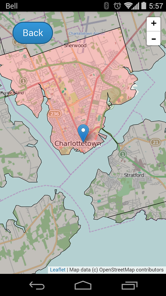
If I tap on the map icon, I see my township – Charlottetown Royalty, in this case – highlighted, and a marker showing my current location:

What's my Lot

If you leave the app running on your device and go for a ride in the countryside, as you cross lot boundaries you’ll see the lot number update as you drive (once you’ve loaded the app, you don’t need to have Internet connectivity for it to work: all of the logic of finding your location and identifying your lot happens on the device, using JavaScript).

The app also remembers which lots you’ve visited, colouring the lots red as you visit them. Collect all 67 (plus 3 royalties), and you win the Island!

This is just an alpha release of the app, to receive feedback in advance of packaging it up for the various app stores in preparation for the 250th anniversary of Holland’s survey next year.  So, please provide feedback.

🗓️

Spotted at the Trinity-Clifton United Church manse fence yesterday around dusk.

Sunflower

🗓️
Sunflowers  •  Photos

Download the ESRI Shapefile version of the lots from the PEI GIS Catalog and open the resulting lot_township_polygon.shp in QGIS.

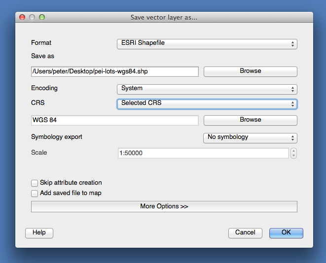
In QGIS, right-click on the layer in the layer browser, and select:

  • Format: ESRI Shapefile
  • Save as (filename): pei-lots-wgs84.shp
  • Encoding: System
  • CRS: Selected CRS (then click Browse below, and select WGS 84)

Your “Save vector layer as…” dialog should look something like this:

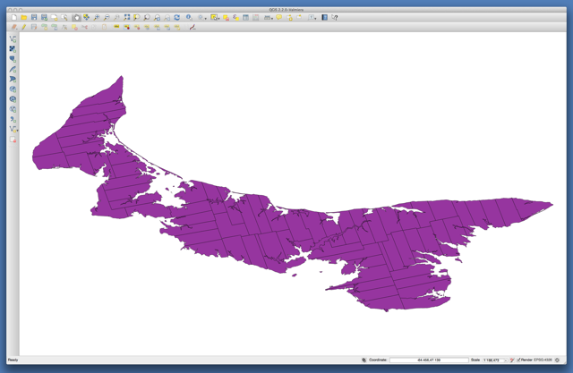
Close and reopen QGIS and open the newly-created pei-lots-wgs84.shp file, which should look like this:

If you save this as a GEOJSON file at this point, because it’s a very-detailed map the size of the file will be multi-megabytes.  We want to create a smaller file, by simplifying the geometer of the lots.

To do this, select Vector menu > Geometry tools > Simplify geometries in QGIS, enter a new file name, pei-lots-wgs84-simplified.shp, using the default tolerance of 0.0001 and click OK to process.

The result will be a new, simpified Shapefile that you can now export to a GeoJSON file; load the new, simplified layer, then right-click on the layer in the layer browser, and select:

  • Format: GeoJSON
  • Save as (filename): lots.geojson
  • Encoding: System
  • CRS: Layer CRS

You can load the resulting GeoJSON file into geojson.io – it’s about 1.9MB.

🗓️

About This Blog

Photo of Peter RukavinaI am . I am a writer, letterpress printer, and a curious person.

To learn more about me, read my /now, look at my bio, listen to audio I’ve posted, read presentations and speeches I’ve written, see things I’ve favourited elsewhere, or get in touch (peter@rukavina.net is the quickest way).

I have been writing here since May 1999: you can explore the 25+ years of blog posts in the archive.

You can subscribe to an RSS feed of posts, an RSS feed of comments, an RSS feed of favourites elsewhere, or a podcast RSS feed that just contains audio posts. You can also receive a daily digests of posts by email. I also publish an OPML blogroll.

Instagram • YouTube • Vimeo • ORCID • OpenStreetMap • Internet Archive • PEI.art • Drupal • Github.