
This is another one of those “I’m putting this here because I know that someone, someday, somewhere will be looking for a solution to this problem” posts.
If you have a delimited ASCII file that you want to import into the OpenOffice.org spreadsheet, in the File \| Open dialog, you need to select Text CSV (*.csv;*.txt) as the “File type.” You have to scroll way down the list of file types to find this option.
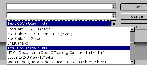
If you just open the file, or open it with file type of “Spreadsheet” or even open it with file type of Text (*.txt) near the top of the file type list, the file will open in the word processor, not the spreadsheet.
In what can only be called a stunningly generous and sensible move, Aliant is making all residential calls to 13 tsunami-affected areas free until February 28, 2005. Here’s their news release; they’re also running ads to this effect.
Regular overseas long distance rates to these countries are expensive: Thailand is $2.29 a minute, India is $1.69 a minute, Burma is $5.69 a minute. Even Somalia, with Aliant’s most expensive per-minute rate of $5.79, is covered under this offer. Bravo Aliant!
In a move intended to solve, once and for all, the problem of how to best arrange its parking lots and the various entrances thereto, administration at the Queen Elizabeth Hospital in Charlottetown today unveiled details of a new “Entrance 2000” plan in a report to the public.
The hospital, which has rearranged its entrance road system several times in recent years, has been plagued with “chronic underperformance of entrance schemology,” says the report.
Under the new plan all parking for the facility will be moved across the Hillsborough River to Stratford. Patients and visitors will be routed to the hospital by a series of high technology pedestrian bridges and zodiac boats.
To ensure the needs of emergency patients are met, a special high-speed luge ramp will be installed over the river, terminating in the outpatient department.
An unnamed source at the hospital, responding to questions about the plan from the media, said “We know there will be challenges adjusting to the new system, but we have faith that this new plan, by moving parking offsite and introducing high technology, will ultimately prove successful.”
Construction is to begin immediately. During construction, patients and visitors will be bused by special high-speed shuttle, from a remote parking lot in Cornwall.
The CBC is reporting that “Northwest Airlines will be offering a new nonstop service between Detroit Metropolitan Airport and Charlottetown this summer.”
On first blush, you might think “who the heck wants to go to Detroit?”
But remember that Detroit Metro Airport is also served by the low-fare Southwest Airlines. Direct service to Detroit means direct service to connecting Southwest flights, which might turn out to be an excellent thing both for Islanders leaving and visitors coming.
For example, an early-June flight from Detroit to Chicago is $39 each way; Burbank, California is $99 each way; New Orleans is $104 each way. Depending on where Northwest sets the Charlottetown to Detroit fares, this could make for very economical travel within North America.
Besides the Southwest possibilities, travel on Northwest itself might prove to be interesting: Detroit is a major hub for Northwest, and they offer direct flights to Tokyo.
Here’s the Detroit Free Press coverage of the story.
It appears as though staff at Online Support are offered company hosted public web pages. That’s a good idea on many levels. I’m a little put off by this part of the Terms and Conditions, though:
Any files created or stored on OLS servers may, at any time, be modified, moved, copied, or deleted, by the OLS IT Department as any work stored on or created with OLS property becomes the property of OLS unless otherwise indicated, in writing, by a senior member of the OLS administration, in advance of creation of each item in question.
Perhaps this is standard corporatespeak; to my eyes, however, it reads like “we own you.” Uck.
I realize I’m talking to a small audience here, but just in case others in the Googlesphere encounter the same challenge, I’ll post a tip here.
I have a vector file of a logo in Freehand. I want to import the logo into Appleworks’ word processor in a format such that when I print the resulting document, the logo is printed at a high resolution.
The key here is to export from Freehand as a “Macintosh EPS” file. Then simply drag-and-drop the file into Appleworks, resize as required, and print.
The result is dramatically better than exporting from Freehand as a large bitmap file and importing and resizing in Appleworks (which results in a fuzzy and jagged logo).
About This Blog
 I am Peter Rukavina and this is my blog. I am a writer, letterpress printer, and a curious person.
To learn more about me, read my /now, look at my bio, listen to audio I’ve posted, read presentations and speeches I’ve written, see things I’ve favourited elsewhere, or get in touch (peter@rukavina.net is the quickest way).
I have been writing here since May 1999: you can explore the 25+ years of blog posts in the archive.
![]() You can subscribe to an RSS feed of posts, an RSS feed of comments, an RSS feed of favourites elsewhere, or a podcast RSS feed that just contains audio posts. You can also receive a daily digests of posts by email. I also publish an OPML blogroll.
You can subscribe to an RSS feed of posts, an RSS feed of comments, an RSS feed of favourites elsewhere, or a podcast RSS feed that just contains audio posts. You can also receive a daily digests of posts by email. I also publish an OPML blogroll.
Instagram • YouTube • Vimeo • ORCID • OpenStreetMap • Internet Archive • PEI.art • Drupal • Github.