In honour of the PEI Teachers’ Federation Annual Convention, happening this week here in Charlottetown, here’s an adaptation of the original Fixer’s Manifesto released on teachinghumans.com:
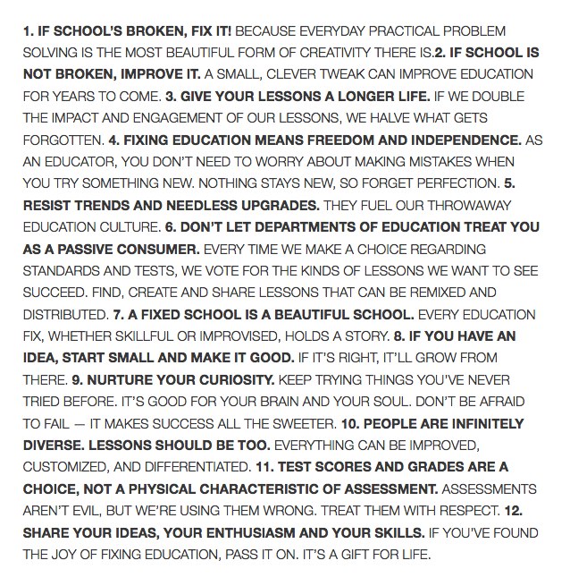

In honour of the PEI Teachers’ Federation Annual Convention, happening this week here in Charlottetown, here’s an adaptation of the original Fixer’s Manifesto released on teachinghumans.com:
As I type there are perhaps 45 minutes left in this season’s run of Anne & Gilbert, the musical theatre extraganza that’s been running since June 18 across a paper-thin wall from our headquarters here in the Reiventorium.
One hundred and thirty-four performances.
One hundred and thirty-four renditions of “Seesaw Girl” and “May I Offer My Umbrella?” and “Forever In My Life.
I’d hazard a guess that, outside of the cast and crew, nobody but me has heard the show more this summer; not all 134 performances, of course. But certainly good sections of 70 or 80.
At times it’s felt like it was never going to end: no matter how wonderful a musical is, having it on an endless loop playing in the loop next door seems like a subplot from LOST.
Many days I would leave for lunch as the show was getting started and marvel at the fact that when I returned an hour or so later it was still running.
But I made it. I even grew to – sort of – love it. Certainly I foung myself whistling the theme from the finale more than I thought I’d ever be whistling, well, anything. Here’s a little taste of what my workday has been punctuated by since, well, forever:
Congratulations to all concerned for what appears, at least through the walls, to have been a banner season.
For more than a month now Oliver and I have been walking to Birchwood Intermediate School every morning just past 8 o’clock. The old walk up Prince Street to Prince Street Elementary was simple: we walked up Prince Street. Birchwood is northeast of our house, though, and so there are a seemingly infinite ways of getting there.
Actually, it turns out that there are 30 ways.
I figured this out using something called Pascal’s triangle. Here’s a simplified version of the street grid that covers the ground between the corner of Prince and Grafton (home) and the corner of Birchwood and Longworth (school) overlaid with the Pascal’s triangle’s binomial coefficients.

It took me a while to get my atrophied brain to understand Pascal’s triangle: this tutorial helped as did this animated GIF from Wikipedia:

This explanation sums it up well:
The first and last entry in each row of Pascal’s triangle is a 1. Every other entry in Pascal’s triangle is the sum of the two entries in the preceding row that lie to the immediate left and right.
So, in other words, we could go Prince-Kent-Hillsborough-Fitzroy-Weymouth-Longworth, or we could go Prince-Euston-Longworth, or we could go Grafton-Cumberland, or we could go Grafton-Hillsborough-Euston-Longworth. Total up the number of possible routes and the total is 30.
If we happened to take any of the 10 routes that pass through the corner of Longworth and Euston, we pass by a Maritime Electric pole in front of 27 Longworth that, for the first few weeks we walked by, looked like this:

I’m a tall guy and that guy wire, often hard to see in the morning sun, was positioned at the right height to catch my head if walking 2-by-2 with Oliver.
But problems have solutions, we tell Oliver.
And so I wrote a quick email to Kim Griffin, personable and award-winning “Manager, Corporate Communications & Public Affairs” at Maritime Electric. She was quick to reply – on a Sunday, no less – and by Monday morning the guy wire had been tightened up and shrouded in a protective and easy-to-see yellow shroud.
Many lessons learned.
News came over the wire this morning that the Province of PEI has prospected a “defence” company to locate on the Island: Island welcomes defence contractor Portsmouth Atlantic. The news release makes it sound like this company is making kittens and apple pie:
“Portsmouth Atlantic is a dedicated centre of excellence for new innovation in environmental management systems for marine technology and specifically a world-leading maker of systems that protect warships from chemical, biological, radiological and nuclear hazards. This is a company with decades of experience, a solid reputation and a growing presence in world markets.”
What goes unstated is that the parent company of Portsmouth Atlantic, Portsmouth Aviation is an arms manufacturer; in addition to making happy products that just keep soliders safe, they also make things that help kill people:
Our more recent activities include the integration and certification of Paveway II / Enhanced Paveway 2 and the Freefall 1000lb Bomb onto RAF Typhoon; the expansion of the release envelope for UK and US weapons on export Tornado, and the provision of hardware and flight trials support to Eurofighter Typhoon partner Nations.
The Royal Air Force has a handy guide to this sort of weaponry.
The last time our government tried something like this was in the mid-1980s when Premier Lee prospected Litton Industries to build an anti-missle radar system on PEI; his successor, the elder Premier Ghiz, under public pressure, subsequently cancelled the deal. Here’s the story as it was told in The Provincial State in Canada: Politics in the Provinces and Territories:

“The strategy will be directed toward finding, and working with, industries which are compatible with the Island lifestyle” is, while perhaps a touch vague to be truly useful, not a bad place to start an economic development strategy. I, for one, would prefer that arms manufacturers not design and manufacture their wares here, and, especially, that our tax dollars not be used to incentivize them to do so.
 Three years ago I had my first meal at The Pearl, the gem of a restaurant on the road between North Rustico. I’ve been back several times since – though never enough times, and only twice so far this year.
If you’ve never been, I highly recommend it: it’s a special place, with excellent food, excellent service, and no pretense.
And this year you’ll have extra opportunities, as The Pearl is extending its season all the way through Christmas, including:
They’re also opening for private dinner parties. Find out more on www.thepearlcafe.ca.
The Atlantic Planners Institute conference was in Charlottetown this year, and I spoke to the group this morning at a session I titled “Planning in Secret: Effective Strategies for Keeping the Public Out of the Planning Process.”
The title, of course, was ironic; as was revealed on slide number two, the real meat of my talk was “Planning in the Open” and I concentrated on reasonable changes that planners can make, without significant investment, in the design and distribution of planning information that can leverage digital tools and digital citizens to good end. Here’s the slide deck I presented from

The slides are licensed under a Creative Commons Attribution-ShareAlike 3.0 Unported License, so you are free to use them, with attribution, for your own devilish purposes. The “man in the blue shirt” slide comes from Ton Zijlstra’s presentation at the Cognitive Cities conference Spice Up Your City: Add OpenGov.
Here are the slides I’ll use for my talk Planning in Secret: Effective Strategies for Keeping the Public Out of the Planning Process tomorrow morning at the Atlantic Planners Institute Conference here in Charlottetown.
Oliver Duncan Lowell Rukavina was born on this day 13 years ago. A so today I become the father of a teenager. Happy Birthday, Oliver!

It’s “Architecture Week” on Prince Edward Island, a fact that the crafty architects of the Architects Association of PEI have (again) worked hard to prevent the public from realizing by updating neither their website nor their Facebook page with any hint that it’s anything more than a regular old week. Fortunately The Buzz steps into the breach and you can get the lowdown there.
I have my own little role to play in the festivities this year: the Atlantic Planners Institute 2013 Annual Conference is taking place here in Charlottetown this week and I’m on the program on Friday morning in a plenary session called “Engagement and Collaboration” where my contribution is labelled “Citizen Engagement”, an attempt, I guess, to boil down the full title, “Planning in Secret: Effective Strategies for Keeping the Public Out of the Planning Process,” into a couple of words.
Here’s how I’ve described what I’ll be talking about in the conference program:
Effective public engagement in community planning in the digital era requires that citizens be equipped with access to a richer set of tools and data about their communities, how they are planned, what is planned, and the success or failure of planning decisions. What have previously been regarded as proprietary tools, techniques and data inside the planning priesthood must be thrown open to (and explained to) digitally literate citizens, and creativity must be applied to developing new techniques for managing expectations, leveraging citizen input to good end, and harnessing the energy and imagination of newly-engaged communities. I will examine the status quo with an eye to pointing out opportunities for simple steps planners can take to improve engagement, and will review the kinds of tools I envision that, in the near future, will enable an entirely new methodology for citizen participation in planning.
All that in 15 minutes or less! My goal is to present planners with a handful of easily implemented open data initiatives they can undertake without spending a lot of money or changing any bylaws. I approach this as someone who knows (next to) nothing about planning: I’m just a citizen with a MacBook and a desire to help broaden the citizen toolset when it comes to making communities.
I’ve been chewing on these ideas since I first proposed the topic a few months ago; this week I’m banking on them being ready for harvest and conversion into a Keynote presentation. I’ll post the slides when there are slides to post.
In the meantime, look at The Buzz and plan your Architecture Open House tour for Thursday: there will be lots of opportunties to drink wine with the talented architects of PEI and learn more about who they are and what they do. I enjoyed myself immensely in 2011, so much so that the switchboard here in the Reinventorium was flooded1 with calls asking where I was when I went MIA for the 2012 edition.
The first unit in Oliver’s grade 7 science curriculum is “Life Science: Interactions within Ecosystems,” summarized, in part, like this:
Ecosystems such as forests, croplands, rivers, lakes, estuaries, and oceans are inhabited by different organisms that are well adapted to their environment. Each ecosystem is biologically and physically unique, yet all ecosystems function as a systems model. Energy from the sun is fixed by plants and then transferred to a variety of consumers and decomposers. The ecosystems themselves are not independent of one another as energy, biotic and abiotic factors can move from one ecosystem to another to involve even larger relationships.
We have, as a result, had ecosystems on the brain in our household for the last couple of weeks, and Oliver and I, on our morning walks to school and our evening walks around town, have been talking about ecosystems and interdependence and sustainability.
Now the city is an ecosystem, and our household is an ecosystem, and the school is an ecosystem, but there’s nothing like a walk in the woods to get hit over the head with “interdependence,” so after our Saturday visit to the Charlottetown Farmer’s Market we headed out to the Winter River to do just that.
I have been helping Bryson Guptill from Island Trails with some mapping work in preparation for Uncover the Island, a big project the organization is undertaking next year, and this work has exposed me to the work of the organization through its website. The Confederation Trail I knew all about; the work of Island Trails to establish and maintain smaller woodland trails across the Island was new to me, and the extensive trail network along the Winter River near Suffolk was something I knew nothing about.
Bryson was one of the participants in the OpenStreetMap Mapping Party I organized back in 2009 and he took to open mapping like a duck to water, using OpenStreetMap to transform the Island Trails website (and OpenStreetMap itself) into a considerably more useful resource by working to include all of the Island’s trails on the OpenStreetMap basemap.
As a result of this work, I was able to call up a detailed map of the Winter River trail system and a description of the various routes on my phone’s web browser once we got to the trail head, and we opted, after reading the trail descriptions, for the shortest trail, one maintained by the Queens County Wildlife Federation, described like this:
This is a short trail, (about an hour walk), through a mature pine and hardwood stand. Three short loops converge at the Winter River, which at this point will satisfy anyone’s conception of a “babbling brook”.
“Babbling brook” sounded very ecosystemy. And so off we headed:
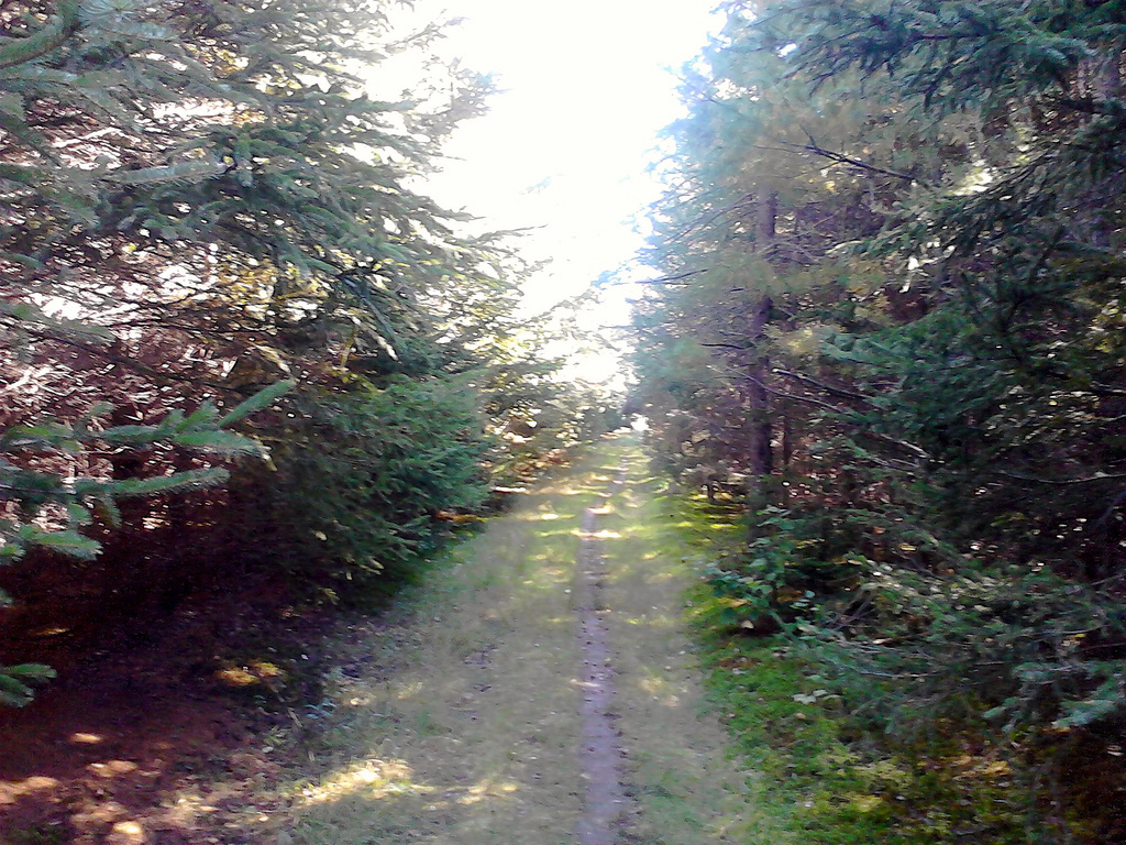
After a slow, easy start, the trails enters the woods and heads downhill toward the river; you need sensible shoes for this part of the walk, and you need to watch out for tree roots, but it’s by no means arduous. After about 15 minutes you come to the riverbank and, true to its description, there is much babbling:
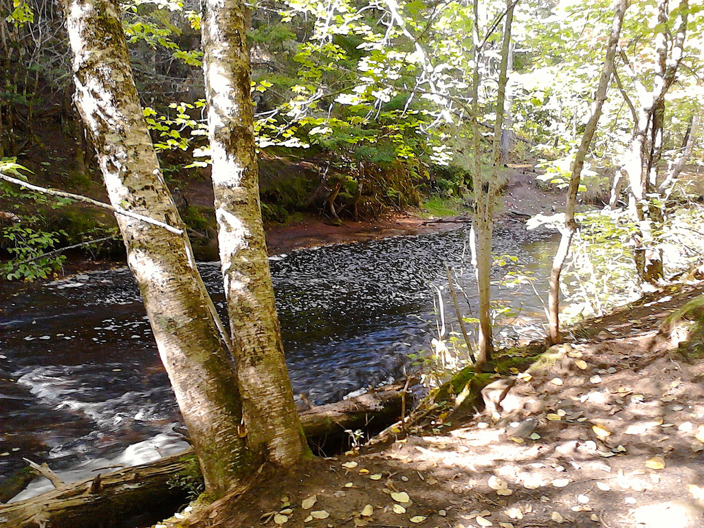
As planned, the walk provided much opportunity to talk about ecosystems. Trees fall, decay, provide food for moss and insects, homes for small animals and, ultimately, turn back into the earth that feeds new trees. And so on. Even more powerfully, though, the Winter River watershed is the source of all of Charlottetown’s drinking water and so in addition to supporting plant an animal life along the walk, the water also supports us.
Now it was my plan, going in, to take a short jaunt down to the river and back. An hour or so, I thought, with a route something like this:
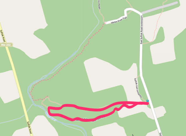
Other than the information signs at the trail head, however, the trail isn’t signed at all, and the GPS in my phone wasn’t working well enough to pointpoint our location as we walked, so that actual route we ended up taking was something like this:
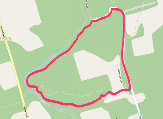
In other words, we missed the turn when it looped back toward the trail head and kept walking along the river until it met up with the end of the East Suffolk Road.
Fortunately the trail along this section was obvious and in relatively good shape so, beyond a thin veneer of being lost, it was a happy diversion, and one that allow us to construct our own bridge from felled logs when we came to a small tributary of the river that offered no other way to cross.
It also allowed us to talk more about threats to ecosystem health when, at the end of the East Suffolk Road, we came across an “excavation pit”:
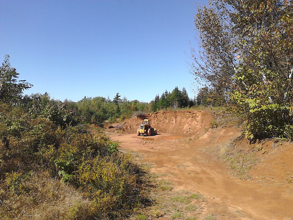
The walk ended up taking about two and a half hours, but we enjoyed it nonetheless. Much was discussed about ecosystems, and I think Oliver emerged with an innate understanding of interdependence of biological systems.
Going back to read more of the grade 7 science curriculum, filled with outcome statements like “describe interactions between biotic and abiotic factors in an ecosystem” and “explain how biological classification takes into account the diversity of life on Earth,” it occurs to me that the curriculum has a glaring hole it it: what we really need is for our children to understand ecosystems in their guts. I’m pretty sure you can’t do this justice when confined to a classroom, no matter how much time you spend on describing “how energy is supplied to, and how it flows through, a food web.”
Walk along the banks of the Winter River: “if you pee in this river, eventually you’ll be drinking little bits of pee when you brush your teeth at home.” Ecosystems understood.
The Winter River trail system is an easy 25 minute drive from Charlottetown: drive out the St. Peters Road and Rte. 2 toward Mount Stewart. Drive past the Rte. 25 to York and take a left on Rte. 229 toward Suffolk. Just before the road crosses the Winter River, turn right on the East Suffolk Road and at the sharp right to the Millcove Road keep driving straight. The trail head is on your left just as the paved road turns to clay.
You can also cycle or walk to the trail head on the Confederation Trail: take the trail out of town and head east at Royalty Junction, over the Union Road, through York to Rte. 229; turn left onto Rte. 229 and proceed as above. Google Maps clocks this as a 23 km, 75 minute cycle ride.
There’s parking for 3 or 4 cars in the lot and a map that shows the Island Trails map is posted in the parking lot (the route we walked is missing from this map, but you can see it on the Island Trails website). Enjoy.
 I am Peter Rukavina and this is my blog. I am a writer, letterpress printer, and a curious person.
To learn more about me, read my /now, look at my bio, listen to audio I’ve posted, read presentations and speeches I’ve written, see things I’ve favourited elsewhere, or get in touch (peter@rukavina.net is the quickest way).
I have been writing here since May 1999: you can explore the 25+ years of blog posts in the archive.
 You can subscribe to an RSS feed of posts, an RSS feed of comments, an RSS feed of favourites elsewhere, or a podcast RSS feed that just contains audio posts. You can also receive a daily digests of posts by email. I also publish an OPML blogroll.
Instagram • YouTube • Vimeo • ORCID • OpenStreetMap • Internet Archive • PEI.art • Drupal • Github.
