
My recent adventures in GPS have me returning to the warm embrace of MapServer, the open source mapping server that I first implemented for the Province of PEI, and later for Yankee. It’s a wonderful project: well supported, well documented, and very powerful.
One of the neat feature of MapServer is its ability to pull map layers from remote WMS servers. Olle asked me “what is a wms server?” and I replied “Think ‘webserver for GIS layers’,” which pretty much covers it.
Here in Canada we benefit from a pleasantly progressive and technically savvy group of mapocrats who consider it their responsibility to spread mapping data far and wide; one result of their efforts is GeoBase, a project that describes itself as existing to “ensure the provision of, and access to, a common, up-to-date and maintained base of quality geospatial data for all of Canada.” That’s pretty cool.
The GeoBase WMS server has a fulsome collection of GIS layers available, including the nascent National Road Network (“the representation of a continuous accurate centerline for all non-restricted use roads in Canada”). Inside the cryptic XML file that describes the capabilities of the GeoBase WMS server, you find the following description of what a “Road Segment” is:
A linear section of the earth designed for or the result of vehicular movement.
It’s a very elegant description, I think — especially the “or the result of” part, which admits that sometimes roads are roads because drivers drive places.
I’m sure that shoplifting is quite dispiriting if you’re in the retail business. But it’s hard to imagine how the owner of the new bookstore in Charlottetown can expect customers to feel welcome when this is the first thing they see:
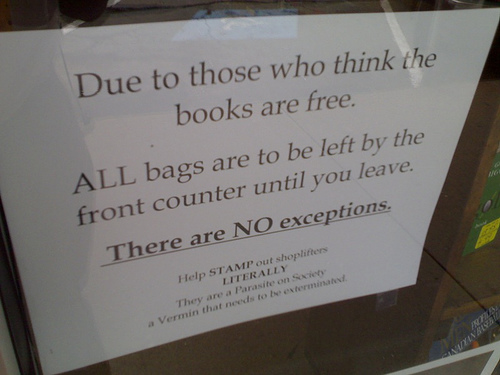
Why not just post a sign that says “I’m going to assume you’re a criminal.”
I’ve begun dumping my GPS traces of cycle rides around downtown Charlottetown into OpenStreetMap and then converting the traces into city streets:
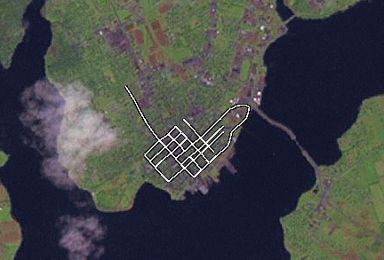
I’ve had some challenges using the web-based map edit applet — it seems to work slowly and inconsistently. But it does work, and the actual trace-to-street process is quite elegant.
Riding my bike down Prince Street this afternoon I spotted a Lexar 128MB CompactFlash card — the kind you stick inside a digital camera — lying on the street near the corner of Sydney St. I picked it up and when I got to the office I stuck it into my USB CF card reader. The card immediately got so hot that I couldn’t touch it. I managed to pull the card out of the socket before it caught on fire or melted. If you’re missing a CF card and don’t mind melting your hands, please get in touch.
The CBC archives has a wonderful video feature from July 1966 on the victory of Alex Campbell’s Liberal government after what amounts to perhaps the oddest election the province has ever seen: after the death of candidate William A. Acorn in 1st Kings, the May 30th election wasn’t decided until a follow-up election on July 11th. Forty years ago next month.
The piece includes a wonderful segment where soon-to-be-Premier Alex Campbell is being interviewed on the street as Premier Walter Shaw drives by in his car and the two candidates share a moment with the interviewer. Only in PEI.
Walter Shaw was 78 that year, Alex Campbell was 32; from here in 2006 he’s still 6 years younger than Walter Shaw was when they ran against each other.
Determined not to lose the euro-momentum that’s still swirling through my spirit, I decided the time was ripe for figuring out how Oliver and I could get to the Charlottetown Farmer’s Market by bicycle. After consulting with the cycling intelligensia — Smooth Cycle, Cynthia Dunsford and MacQueen’s — I ended up renting a “chariot” to pull behind my bike:
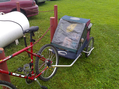
The rental experience, at MacQueen’s, was classic PEI: they took my name and $40, hooked up the trailer and I was on my way; in the Big City I would have had to hand over my passport, have my photo taken, or at least leave my telephone number.
The trailer is very easy to attach to the bike — it just clamps on to the back with a handy quick-release mechanism. I was in and out in 5 minutes.
The big issue with towing fragile kids behind a bike is safety — as a rule Island drivers don’t understand bicycles, and when you throw a low-slung trailer behind them, it doesn’t improve the safety quotient. Inside the trailer there’s a bench that can accommodate one or two kids, and a variety of five-point harness straps for holding them in; to improve our chances of not being run over, I figured out the most road-free route to the market and out to the uptown Formosa Tea House: we headed down Richmond St. to Weymouth, joined the Confederation Trail and headed out to the Market, crossing streets at Grafton, Longworth and Allen. After a stop at the Market we headed through the University of PEI campus, by sidewalk down the dip out to the mall, cross University Ave. and then cycled through the Charlottetown Rural parking lot over to a path that runs out to North River Road right in front of Ellen’s Creek Plaza.
The trail is an excellent riding surface, and it’s a nice resource to have, cutting through the spine of the city as it does. It could use some additional “bike crossing” signage and road markings when it crosses roads — only 50% of cars stopped to let us cross (on foot) despite the zebra markings.
The one thing I didn’t count on was rain. It was drizzly when we set off, but I naively assumed that the rain was on its way out, not in. I was wrong: by the time we left the Formosa around 1:00 p.m., there was a steady downpour. Fortunately, Oliver was happily ensconced inside the trailer under a plastic curtain, and stayed dry all the way home. I got wet, but not too wet, all things considered: my bike helmet kept most of the rain off my head, and did a good job keeping rain out of my eyes.
If it’s a nice day tomorrow, we’ll be out again to get some additional experience. MacQueen’s says they’re getting in new stock of a sweet single-kid chariot in a few weeks, retailing for $199; I’ll have to consult with Oliver to see whether the bike-trailer lifestyle is for us.
Here’s a new poster that Downtown Charlottetown Inc. is using to promote the core as a place for working. Ah yes, downtown working — I can take my jacket off, sling it over my shoulder, and talk on my sleek mobile phone. At least when I’m not gathered around a laptop in a pure white room working with colleagues.
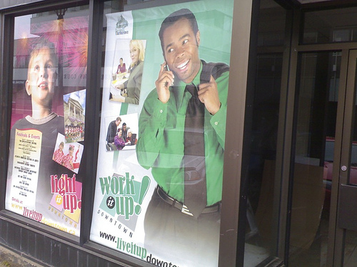
I’ve always been firmly in the “if it’s a good idea, it will work” camp, and I find lifestyle marketing like this to not only be insulting — I actually do work downtown, and that’s about as far from my photographic reality as you can get — but simply misguided and wasteful.
For more of same, see the companion website where you can learn about the “endless excitement around every corner.”
Now that there’s a version of the Plazer for Series 60 mobile phones (it’s in beta right now), the question of how much data it actually takes to ping the Plazes server with location information becomes important — at 5 cents/KB, data costs can mount quickly, especially for an application designed to run all the time.
Here’s what my Nokia N70 reports was the GPRS data usage after launching the Plazer and identifying my current location:
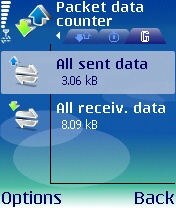
That’s 3.06KB of data sent out and 8.09KB of data returned, for a total of 11.15KB. It cost me 50 cents with a Rogers Wireless “Pay As You Go” account:
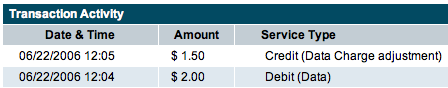
Assuming 5 location changes a day, that would amount to about 1.7MB in data, or $75/month in data charges to run the Plazer all the time. This could be mitigated somewhat by upgrading to a “real” data access account — Rogers sells a $25/month plan that includes 3MB of data transfer.
One of the reboot presentations that intrigued me the most was the one by Steve Coast on the OpenStreetMap project.
The goal of the project is to assemble an freely available set of street map data, data that will enable the building of interesting map application free of the encumbrance of costly and complicating map data licenses. To this end they’ve built a robust set of tools to allow grassroots users to gather data about streets using inexpensive GPS devices, add them to a central data set, and then convert them into “ways” — streets to you and me — with names and directions and connections.
In other words, the kind of project that has “I’ve got to get this started for Charlottetown” written all over it.
So I’ve started. Here’s how I do it.
First, my “gather GPS traces” setup. I’ve installed Python for S60 on my Nokia N70. This lets me run the excellent and free S60 Python NMEA Bluetooth GPS Info Viewer tool that logs GPS traces to an NMEA-format file. The GPS stream itself comes from my GPSlim 236 Bluetooth GPS which talks to the phone, as you might imagine, via Bluetooth. Here’s what the process of getting things running looks like:
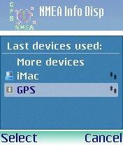
Start the nmea info application.
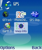
Select the Bluetooth GPS receiver to use.
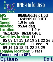
The logging of GPS traces starts automatically.
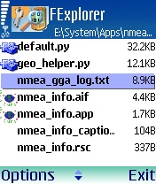
Once I’m done, I find the nmea_gga_log.txt file in E:\System\Apps\nmea_info…
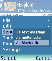
…and I send it to my desktop for processing.
Now I’ve got a file on my desktop called nmea_gga_log.txt that’s in the NMEA format. To send this to OpenStreetMap I first need to convert it to GPX format. Fortunately the (excellent) GPS Visualizer website has a tool for this job:
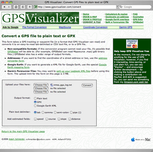
I end up with a GPX-format file that I can upload to OpenStreetMap:
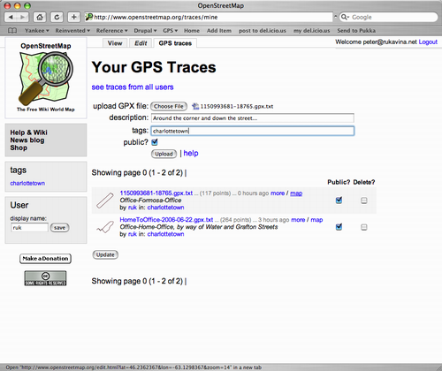
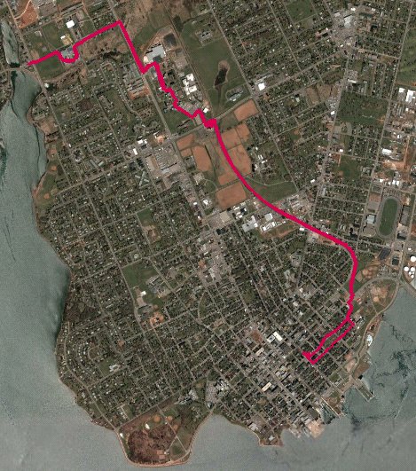
Once my traces are uploaded and processed, I can use the OpenStreetMap web-based edit applet to see my traces:
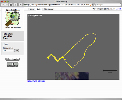
That’s a trace of a walk from the office to home, followed by a cycle, via Water St. and Grafton St., back to the office. The next step — which I’ve yet to do — is to convert those raw traces into “real streets.” I’ll document that process once I’ve done it once!
About This Blog
 I am Peter Rukavina and this is my blog. I am a writer, letterpress printer, and a curious person.
To learn more about me, read my /now, look at my bio, listen to audio I’ve posted, read presentations and speeches I’ve written, see things I’ve favourited elsewhere, or get in touch (peter@rukavina.net is the quickest way).
I have been writing here since May 1999: you can explore the 25+ years of blog posts in the archive.
![]() You can subscribe to an RSS feed of posts, an RSS feed of comments, an RSS feed of favourites elsewhere, or a podcast RSS feed that just contains audio posts. You can also receive a daily digests of posts by email. I also publish an OPML blogroll.
You can subscribe to an RSS feed of posts, an RSS feed of comments, an RSS feed of favourites elsewhere, or a podcast RSS feed that just contains audio posts. You can also receive a daily digests of posts by email. I also publish an OPML blogroll.
Instagram • YouTube • Vimeo • ORCID • OpenStreetMap • Internet Archive • PEI.art • Drupal • Github.