
I got an email, tailor-made for procrastination, this morning from a correspondent in Prince County:
Do you know if there is an online map of the boroughs, neighbourhoods, districts of Charlottetown? There is a Wikipedia page for “Neighbourhoods of Charlottetown”, but I’ve never seen a map that shows these areas.
I couldn’t find one either, so I set out to fill that hole in the digital landscape.
The constituent parts of the modern-day City of Charlottetown are as follows:
- Spring Park, originally a village, Spring Park was amalgamated into Charlottetown in April 1958 (source).
- Parkdale, a Village as of 1958, Parkdale became a Town in 1973, and was amalgamated into Charlottetown in April 1995 (source).
- Sherwood, a Village as of 1969, Sherwood became a Community in 1983, and was amalgamated into Charlottetown in April 1995 (source).
- West Royalty, originally a post office, then a Settlement, became the Community of West Royalty in 1980, and was amalgamated into Charlottetown in April 1995 (source).
- East Royalty, a Settlement as of 1939, became a Locality in 1960, a Community in 1976, and was amalgamated into Charlottetown in April 1995 (source).
- Hillsborough Park, a Village as of 1976, became a Community in 1983 and was amalgamated into Charlottetown in April 1995 (source).
- Winsloe, a Settlement in 1939, became the Community of Winsloe in 1971 and was amalgamated into Charlottetown in April 1995 (source).
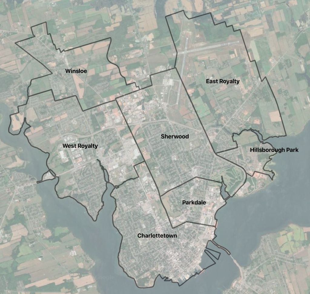
Just before amalgamation in 1995, the map of these parts looked like this (boundaries from this provincial GIS layer):
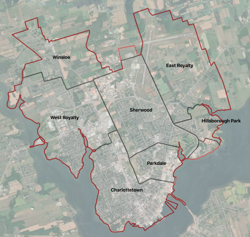
After the 1995 municipal amalgamation, the constituent communities were downgraded to “neighbourhoods,” and, together with the land on which the Queen Elizabeth Hospital sits, and a small area north of Charlottetown Airport where there’s an industrial park today, became modern Charlottetown, with the boundary shown in red on this map:
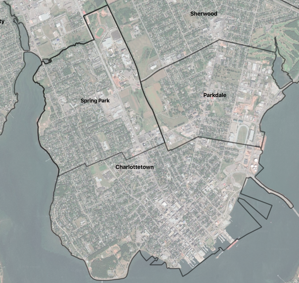
Before Spring Park and Charlottetown were amalgamated in 1958, their boundaries looked like this (Spring Park boundary from this helpful map):
If you’re, say, from Prince County, and want to do a familiarization tour of Charlottetown’s constituent communities, here are directions:
- Driving into the city across the North River Causeway, you’ll enter West Royalty.
- Continue along Capital Drive to the Charlottetown Mall, turn right down University Avenue, and as you pass the UPEI field on your left you’ll be entering Spring Park.
- Continue south on University Avenue and as you pass the Dairy Queen on your right you’ll be entering original Charlottetown.
- Take a left on Euston Street and continue to the confusing intersection–Ken’s Corner to locals–of Longworth Avenue, where you’ll confusingly turn left. Continue on Longworth until you pass the 1911 Jail on your left near Belmont Street; you’re now entering Parkdale.
- Longworth turns into St. Peter’s Road; at the confusing intersection–Ellis Brothers to locals–with Brackley Point Road you’ll be entering Sherwood.
- Continue on St. Peter’s Road, through the confusing intersection with the bypass; on the other side of the bypass you’ll be in East Royalty.
- As you go through the roundabout on the other side of the bypass, take an immediate right onto Northridge Parkway, and continue along until it ends at Hunter Lane; you’re now in Hillsborough Park.
- Continue on Hunter Lane to Patterson Drive, where you’ll take a right and continue to Southgate, turn left and then right onto the bypass; take the bypass all the way to Route 2, where you’ll see Leons and Kent, and take a right onto Route 2. As you pass the Sherwood Road you’ll be entering Winsloe.
The tour should take you about 45 minutes if you don’t stop at the Dairy Queen.
If you’d like to explore this geography in more detail, and make your own maps, here are the data layers I used to make mine:
- pre-amalgamation-charlottetown.geojson – derived from this provincial GIS layer, with Cornwall, Stratford and Summerside removed, a few bodies of water removed, and labels added to the communities. Credit for the original layer to L.R.I.S., 20050725, Prince Edward Island Pre-Amalgamation Boundaries: Prince Edward Island Finance and Municipal Affairs, Taxation and Property Records, Geomatic Services, Charlottetown, Prince Edward Island, Canada.
- springpark.geojson – derived from this Google My Maps map, with various subdivisions and other features removed leaving only the boundary. There’s no identifying information on the map as to its original source.
- charlottetown.geojson – derived from this provincial GIS layer, with municipalities other than Charlottetown removed. Credit for the original layer to L.R.I.S., 20050725, Prince Edward Island Municipal Boundaries: Prince Edward Island Finance and Municipal Affairs, Taxation and Property Records, Geomatic Services, Charlottetown, Prince Edward Island, Canada.
Other resources you might find useful in learning more about Charlottetown and its parts:
- Charlottetown Area Municipalities Act, which describes the amalgamation (it’s since been repealed and replaced by the Municipal Government Act).
- The Geography of Governance: An Overview of Boundaries Powers and Responsibilities on Prince Edward Island, by J.A. Cousins.
- The PlaceFinder, one of the few remaining parts of provincial data infrastructure remaining in operation that I created, and one of my proudest creations at that; for each geographic name in the province you can get the official history of the name from the Canadian Geographic Names Database.
While my Prince County correspondent was, I suspect, asking “hey, if you ever come across a map, let me know,” answering their query in the form of a blog post was, indeed, an excellent way to procrastinate on a Friday afternoon.

Comments
Hi Peter,
This is great information. Thank you so mush for putting this together.
I searched this for curiosity sake but I love the fact that you added an historical aspect to this document too. Very nice to see how the City boundaries changed and amalgamated overtime.
Having a map with all the neighborhood names and respective locations is also helpful.
Simply wanted you to know this type of information is appreciated!
Best regards,
Pierre