I honestly don’t know how we found out about TRUCK Furniture and Bird Coffee in Osaka. We hadn’t even planned to visit Osaka on our trip to Japan – to be honest, until last week I wasn’t even sure where Osaka was – so it surely wasn’t the result of careful advance planning. But, somehow, last Saturday afternoon, we decided to venture there, and hopped on a bus in downtown Osaka toward what turned out to be the neighbourhood where TRUCK used to be. Oops. After a good cup of coffee, we gathered our spirits and headed off on the metro toward the neighbourhood where TRUCK is actually located.

Emerging from the Shimizu metro station, we walked through narrow streets at twilight, finally arriving, after about 10 minutes, in front of two minimal beige buildings separated by an alley: TRUCK on the left, Bird on the right. We were famished, and Bird looked bright and warm and inviting, so we headed in for supper.

Bird in Osaka at Night

We were greeted warmly, and shown to a table (a TRUCK-made table, as it turned out), and a kind and patient waiter brought us menus (in Japanese with a few English words thrown in helpfully) and with the help of my “point the camera at the word and I’ll translate it for you” app on my phone (a technical violation of the “please turn your phones off” guidance by the door) we translated ourselves into a pork cutlet (ポークカツレツ) for Oliver and a Turkish avocado and bacon sandwich (アボカドとベーコンのターキッシュサンド) for me, along with a glass of red wine and an orange juice.

There was jazz on the PA, and a bustle of diners filling up the place, and the vibe was relaxed and neighbourhoody, and when our food arrived we wolfed it down.

Bird Meal Done

By the time we’d finished up and were back out into the Osaka night it was well-past the 7:00 p.m. closing time at neighbouring TRUCK, so we walked back to the metro and made a note to visit again if we could, if not on this trip then on the next.

As it happened, on Monday morning we were both in need of coffee and with a few hours to spend before taking the Shinkansen back to Tokyo so, after stashing our bags in a locker at the Shin-osaka station we made our way back to TRUCK and Bird for an encore.

We took a different route to a different metro station for our second visit, walking from the Morishoji metro through a mixed commercial-residential neighbourhood — the kind of “oh, my, I wouldn’t mind living here” neighbourhood you sometimes encounter — approaching TRUCK and Bird from the other direction.

We were greeted by the same waiter who had served us on Saturday night — “Welcome back!” he said, enthusiastically — and this time, for lunch, we ordered two “Bird Rice” (Birdライス) and a cup of coffee with milk, which was served in a substantial brown mug on a well-proportioned wooden platter:

Bird Coffee

We really didn’t know what “Bird Rice” was, but our waiter said it was quite popular, so we dove in blind. It turned out to be exactly what you might imagine it to be: a bed of rice topped with a ring of pumpkin, cabbage and other vegetables with a poached egg sitting in the middle to form a “nest.” I quickly passed my egg of to Oliver, not being a fan; everything else, though, was tasty in a way you wouldn’t imagine from something so simple.

After relaxing in the sunny Osaka afternoon for a bit, we paid and headed across the alley and up the stairs to TRUCK.

It’s hard to do justice to TRUCK Furniture in words, for their products — simple, beautiful, functional furniture — really must be experienced to truly understand them. They make things that don’t hit you over the head with “style” but rather things that feel, on sitting on them or at them or around them, like they have been in your life forever.

Inside Truck Furniture

The retail space is comfortable and airy and bright and the the kind of space where you’d want to spend a lot of time. Indeed visitors appear to be encouraged to sit and read or watch or think — to get a handle on the furniture. TRUCK doesn’t make cheap furniture — tables cost thousands and chairs cost hundreds — but it seems like these would be pieces that would follow you for life; the sort of opposite of IKEA.

We wandered the aisles for 30 minutes, looking and sitting and touching, and then picked up a copy of the excellent history of the operations and the lives that begat them, TRUCK nest, the introduction to which is a good thumbnail sketch:

For years TRUCK has created simple, honest furniture in their workshop in Osaka, Japan. This book traces the nine-year journey of Tokuhiko Kise and Hiromi Karatsu, the couple behind TRUCK, as they set out to create a place of their own, where they could live and work comfortably with their large family of one daughter, five dogs and eight cats.

Together they planned and constructed a house, a store, a workshop and, with the help of their friend, celebrity chef Kentaro, a cafe called Bird, and surrounded them with individually selected trees and plants.

I’ve been reading it over the weekend, and it’s an inspiring tale and, in a sense, a call to arms to live life more intentionally.

If you happen to find yourself in Osaka, I encourage you to drop by for a meal and a visit.

🗓️
Osaka  •  TRUCK Furniture  •  Bird Coffee

You’re not allowed to take photos inside the Ghibli Museum in Tokyo (a museum that, sadly, we were too late off the mark to get the required advance tickets for).  The museum’s website describes their rationale for the policy:

The Ghibli Museum is a portal to a storybook world. As the main character in a story, we ask that you experience the Museum space with your own eyes and senses, instead of through a camera’s viewfinder. We ask that you make what you experienced in the Museum the special memory that you take home with you.

As with navigating by GPS, the introduction of digital cameras, without the limiting factor of expensive film, into the travel-with-children experience is something I think a lot about. Visit any children’s museum or science museum these days, and 75% of parents with children will have a camera out and will be taking photos of their kids. A lot of photos.

I know from my own experiences that focusing on recording the experience means, of necessity, not participating in the experience yourself; if you’re busy taking a photo of your kid getting dressed up in a kimono you’re staging a performance, not engaging in an activity.

I don’t think it’s impossible to do both, to record and engage, and I do believe there’s a larger value in at least some recording. But I also know that engaging with children, actually doing something with them, takes effort and concentration, and that interrupting that to fiddle with a camera can ruin that engagement.

IMAG0370

🗓️
Tokyo  •  Museum

Japan in known for having a difficult-to-parse street-addressing system and Tokyo is equally known for having a labyrinthian metro system, both of which make travel for tourists more challenging. Fortunately, in our case, both of these were mitigated significantly by using Google Maps on our rented Android phone to find our way.  Google Maps has excellent coverage in Japan (in contrast to both Apple’s and Nokia’s maps offerings, which pale by comparison), and Google has particularly good transit routing; I can’t imagine how we would have navigated Tokyo, Kyoto and Osaka without it.

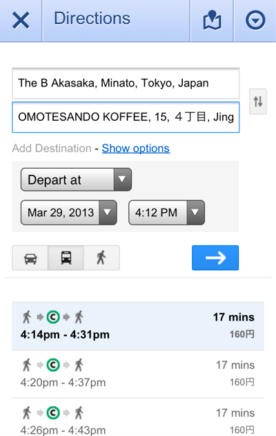
For example, here’s how a routing from our Tokyo hotel, The B Akasaka, to Omotesando Koffee a couple of metro away, stops looks like:

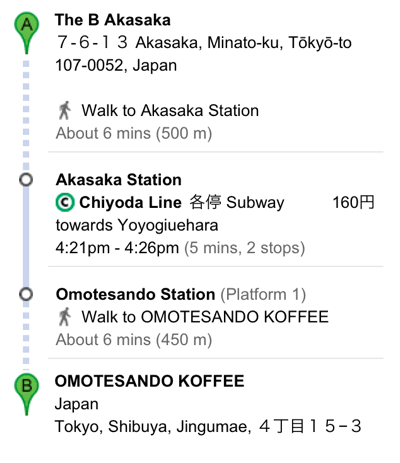
Google Maps recognized both places as I was typing their names, and gave me the next metro times from the nearest station, along with the cost (160 Yen); selecting any one of these I get step-by-step directions, including the platform number, train direction and number of stops:

And touching any of the steps along the way shows even more detail:

From that map I can clearly see that I want to take exit A2 out of Omotesando station (a very useful piece of information as that metro station along has myriad exits spanning many different city blocks).

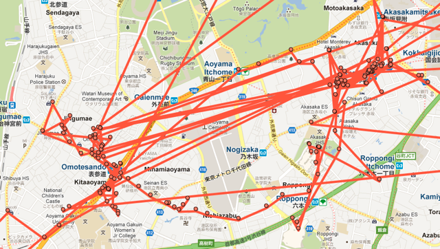
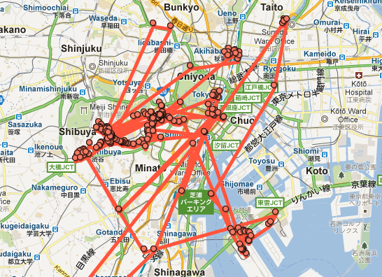
While I truly can’t imagine how we would have efficiently navigated Tokyo without Google Maps, I equally realize that outsourcing our wayfinding to Google came at a price.  Here, for example, is a Google Latitude trace of our travels around the Akasaka neighbourhood on the right and the Omotesando neighbourhood on the left. We took the metro back and forth myriad times for different purposes, ended up walking, through the Roppongi district, from one to the other once, and spent a lot of time in and around each neighbourhood:

It is only now, however, looking at these traces, that I have any real sense of how these neighbourhoods sit relative to each other geographically. I realize only now that places in Omotesando that I thought of as being miles apart were actually on adjacent blocks. I realize only now that there was a huge cemetery  between the two neighbourhoods that we skirted once as we walked, but otherwise weren’t mindful of.

It’s this kind of context that I would have been forced to gain in a pre-Google Maps travel world, where a good printed map of the area and a more detailed manual parsing of the metro network would have been the only tools at hand.

Don’t get me wrong: I treasured the efficiency that Google Maps’ routings afforded us. But in its efficient point-to-point routing what we lost was a greater sense of place. We were, in a sense, being routed by Google as packets in a network, emerging from the metro at various points in the network that is Tokyo to engage in some activity or another, only to go back underground to emerge somewhere else, completely unmindful of how point A and point B might relate to each other culturally or geographically.

Amidst a discussion on this notion, Sami Niemelä tweeted earlier today “I love navigating new cities with no GPS or even maps. Getting lost gracefully is a form of art” and pointed to the description of a McGill University study, “Study suggests reliance on GPS may reduce hippocampus function as we age” that says, in part:

There are two major ways of navigating: by spatial navigation or by stimulus-response methods. The spatial method uses landmarks and visual cues to develop cognitive maps that enable us to know where we are and how to get where we want to go. The second method relies on repeatedly traveling by the most efficient route, as though on auto-pilot. The second method will be familiar to those using GPS.

In Japan we were clearly in the “as though on auto-pilot” camp, and, beyond any long-term effect on our hippocampi, I truly do believe we lost something in the process, whether it be “getting lost gracefully” or simply understanding the lay of the land more intimately.

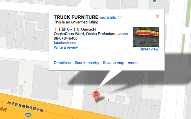
Ironically one of our favourite discoveries in Osaka happened due to a Google Maps accident. We were trying to find Truck Furniture and relied upon an “unverified” Google Maps listing to get us there:

This turned out, in fact, not to be the location of Truck Furniture at all (it was 90 minutes walk away to the north). But what we did find, on the next corner, was the excellent Cafe Noto, a “third wave” coffee shop, where I had an excellent espresso and Oliver an excellent crème brûlée. It was a discovery we never would have made without “getting lost,” and a highlight of our visit to the city.

The McGill researchers suggest a hybrid approach to navigation might be in our longterm best interest:

Bohbot suggested it may be wise to restrict GPS use to an aid in finding the way to a new destination, but to turn it off on the way back or when going somewhere that is not new. Building cognitive maps takes time and effort, but with the hippocampus, it may be a case of “use it or lose it,” and Bohbot said she does have fears that reducing the use of spatial navigation strategies may lead to earlier onset of Alzheimer’s or dementia.

I don’t know about dementia, but I do know there’s value, and joy, in understanding geography, making mental models of places, and in getting lost. So perhaps on our next trip to Japan we’ll do some more aimless wandering in addition to our precision-targeted packet routing.

🗓️
Google Maps  •  Public Transit  •  Japan  •  Tokyo  •  Osaka

While we were in Japan over the last two weeks I was using a rented HTC Evo from Global Advanced Communications. While the customer service from the company was excellent — the phone was waiting at the desk of my hotel when we arrived, as promised, and was all ready to go — the phone itself was a klunky older model, very bug-prone (apps, especially Google Maps, crashed regularly; keyboard input was difficult) and the promised “max 40 Mbps” of throughput via WiMAX never amounted to much more than 1 Mbps. And the battery was incapable of supporting a full day’s worth of use (fortunately a spare battery was included, which I needed to use from about 4:00 p.m. onward every day). 

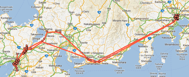
But it did the job, had a good camera (see the results in Flickr), and, being an Android phone, was dead-simple to connect to my existing Google ecosystem.  Including Google Latitude. Which means that we have a very nice set of digital breadcrumbs of our trip. Here’s our footprint in Japan over 13 days:

Here’s our footprint in Tokyo, where we were from March 14 to 20 and then again from March 25 to 27:

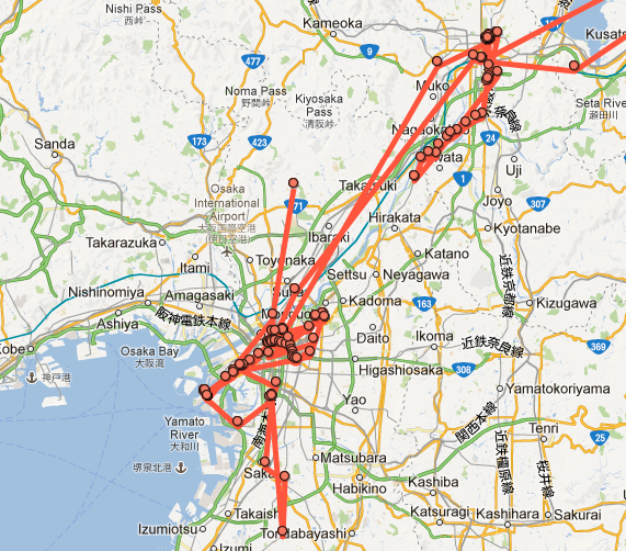
And here’s Kyoto and Osaka, where we were from March 20 to 25:

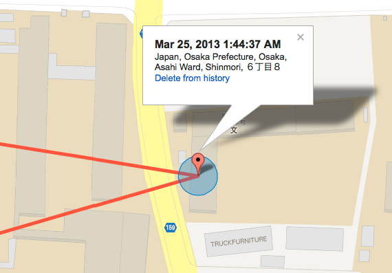
It’s all frightfully accurate, and thus useful for tracking down “when exacting did we eat lunch at Bird?” or “where was that little gallery we visited?” Here’s that lunch at Bird, for example, on Monday morning before we left Osaka (it’s in PEI time; Osaka time was 12 hours ahead, so it was just before 2:00 p.m. on Monday):

One of the projects I plan to carry out during my Hacker in Residence project at UPEI is a mechanism for slurping in geopresence for a variety of sources into a “personal geopresence archive.” Google Latitude, along with Foursquare, Twitter, Plazes, and other sources will be the target data sources, and this Japanese trip gives me a nice place to start.

🗓️
Japan  •  Travel  •  Oliver

IMAG0409-1

Blame Ian for this. Certainly easier than tapping it all out on the glass keyboard of the iPad. Click to see it bigger.

🗓️
Japan  •  Travel  •  Osaka

Breaking radio silence briefly to point you to our ever-expanding collection of photos from Japan. We are in Kyoto as I type, after 6 great days in sunny, warm Tokyo.

🗓️
Japan  •  Tokyo  •  Travel

Oliver and I are off to Japan in the morning. We take the 6:00 a.m. flight from Charlottetown to Toronto, then fly from Toronto to Washington Dulles, and finally head for Tokyo on United 803, arriving 4:35 p.m. local time on Thursday. Japan, conveniently, is currently 12 hours ahead of Charlottetown (a nice counterpart to the “1 yen is about a penny Canadian”), so we’ll be landing 2:30 a.m. on Thursday morning Charlottetown time.

But they tell me it’s best to not think of these things, and to get yourself into the headspace of the destination. So I’m thinking hard about it being 9:00 a.m. on Wednesday as I type (despite what the clocks tell me, and it being dark outside, and me being ready to go to bed). Talk to you from the other side of the world.

🗓️
Travel  •  Oliver  •  Japan

It might appear to careful readers that I have given up the ghost on this hacker-in-residence blog. But I haven’t. I’ve been away on other business for the first part of March and now I’m off to Japan with my son for a vacation for the rest of the month. Regular hacking will resume in April.

In the meantime, perhaps you’d like to register for a pre-conference workshop I’m presenting on May 14th for the Atlantic Provinces Library Association annual conference called “DIY Mapping for Libraries.”

🗓️

Catherine spoke to CBC’s Karen Mair about her show in the Confederation Centre Art Gallery; listen:

(Embedded audio widget courtesy of A Better Embedder, which is really quite wonderful).

🗓️
Radio  •  CBC  •  Catherine  •  Art

Last night the City of Charlottetown held a public meeting about the proposed National Folk Festival in Victoria Park. The meeting was required under the Victoria Park and Promenade Bylaw:

Where the Parks and Recreation Manager, in consultation with the Parks & Recreation and Culture Committee, determines that a proposed special event is a major event, then the application for use shall be referred to Council who will by resolution approve (with or without conditions) or reject the application. Council will, before reaching a decision, hold a public meeting to receive public input as to whether or not, and if so, on what conditions the proposed major event ought to proceed.

The bylaw currently in place, last amended in 2009, is the successor of the original bylaw, passed in June of 1873, a bylaw that stated, in part:

The said lands shall be used, appropriated and set apart by the said City, at the expense of the said City, for the sole purpose of a Park, Promenade and Pleasure Ground, for the use of the citizens, the inhabitants of this Island, and all Her Majesty’s subjects.

The said City shall not, on any account whatsoever, use, or permit to be used, the said lands, for the purposes of Circuses, Shows, or Exhibitions of any kind, whatsoever, and should the same be so permitted to be used by the said City, the lands hereinbefore mentioned shall revert to and be vested in Her Majesty, her heirs and successors.

At last night’s meeting I stood up to oppose the granting of permission to use Victoria Park for a folk festival because I believe that public spaces should be free and open to the public; I believe this same spirit was reflected in the original bylaw: “for the use of the citizens, the inhabitants of this Island, and all Her Majesty’s subjects.”

There has been a disturbing trend in recent year in Charlottetown to wall off public spaces – Confederation Landing Park, Victoria Row, sections of Queen Street, and Victoria Park – for the exclusive use of ticket-buyers. The justification for these walls is most often some combination “it’s only for a weekend” or “it will bring huge tourism dollars to the city”; these rationalizations ignore the fundamental rights of all the citizens of the city, rich and poor, to benefit from public spaces.

When we put up walls in Victoria Park and say to our citizens “you can only go in this space – this space you and your ancestors have paid for and stewarded – unless you can come up with $100 for a weekend pass” we are disenfranchising many of our fellow citizens for whom such expense is simply not managable.

I’m a big supporter of the folk festivals and of folk music in general; I think the team behind the proposed National Folk Festival is top flight, and their proposal is well-considered. But I cannot conscience supporting an event that excludes some of my friends and neighbours on economic grounds. I think our ancestors understood this, and I think it’s time we did the responsible thing and update the bylaw to clearly state that public spaces are for the public, for all the public.

🗓️
Charlottetown  •  Music  •  Politics  •  Design

About This Blog

Photo of Peter RukavinaI am . I am a writer, letterpress printer, and a curious person.

To learn more about me, read my /now, look at my bio, listen to audio I’ve posted, read presentations and speeches I’ve written, see things I’ve favourited elsewhere, or get in touch (peter@rukavina.net is the quickest way).

I have been writing here since May 1999: you can explore the 25+ years of blog posts in the archive.

You can subscribe to an RSS feed of posts, an RSS feed of comments, an RSS feed of favourites elsewhere, or a podcast RSS feed that just contains audio posts. You can also receive a daily digests of posts by email. I also publish an OPML blogroll.

Instagram • YouTube • Vimeo • ORCID • OpenStreetMap • Internet Archive • PEI.art • Drupal • Github.