As a result of various summertime adventures, the OpenStreetMap data for Prince Edward Island is starting to actually look like the Island:
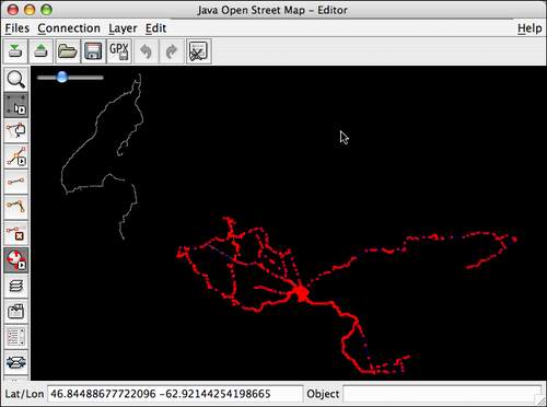

As a result of various summertime adventures, the OpenStreetMap data for Prince Edward Island is starting to actually look like the Island:

I am Peter Rukavina and this is my blog. I am a writer, printer and developer.
To learn more about me, read my /now, look at my bio, read presentations and speeches I’ve written, listen to audio I’ve produced, see the places I’ve been, or get in touch (peter@rukavina.net is the quickest way).
Mailing Address
100 Prince Street
Charlottetown, PE
Canada, C1A 4R4
Comments
Traces of activity giving shape to a map, I like it. How do I make my mark here in the dark on this map?
Hey,
Cool to see someone else working on “the map”. Passed through PEI on a grand tour of the maritimes in early September. You can see my (incomplete) handy work if you look for the major highways through new brunswick, pei, nova scotia, and back through quebec to ontario. I’m in Ottawa and busy filling in small bits at a time.
Anyways, just thought I’d drop you a line when I ran across this post looking for something else…