
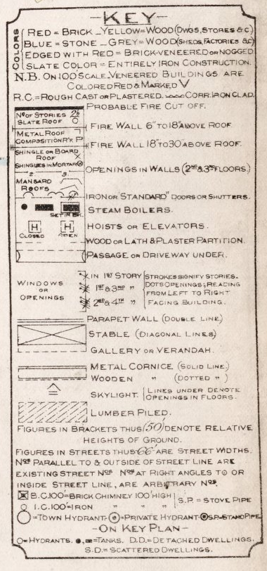
From Island Imagined, a Robertson Library map-scanning project, here’s a page from the 1903 Fire Insurance Map of Charlottetown. Our house, at 100 Prince Street, is in the bottom-left corner in the 53rd block.
There’s city-wide map that acts as an index to the individual map pages; my favourite part of that map is the legend:
About This Blog
 I am Peter Rukavina and this is my blog. I am a writer, letterpress printer, and a curious person.
To learn more about me, read my /now, look at my bio, listen to audio I’ve posted, read presentations and speeches I’ve written, or get in touch (peter@rukavina.net is the quickest way).
I have been writing here since May 1999: you can explore the 25+ years of blog posts in the archive.
You can subscribe to an RSS feed of posts, an RSS feed of comments, or a podcast RSS feed that just contains audio posts. You can also receive a daily digests of posts by email.
Comments
Hey, look, the fire hydrant’s
Hey, look, the fire hydrant’s still in the same place!
<img width=”500” height=”375” alt=”Fire Hydrant” src=”http://farm3.static.flickr.com/2345/5708086441_9c2df5cfaa.jpg”/>
Add new comment