
When our family moved to the small village of Carlisle in 1972, it still deserved the description “small village” as it was a sleepy residential farming community of 450 people, 30 minutes from Hamilton. In the intervening 30 years Carlisle has been heavily developed, with several large subdivisions of former farmland into modern residential developments.
Mom and Dad’s house — the house I called home intil 1985 — was built in the middle of the last century. It’s a modest single family home on a 2 acre plot of land. Throughout much of my childhood the family project was the planting of trees on the back portion of the land; the healthy forest that sits where a once was only a field is a testament to our labours.
When I was home last week with Oliver I had my first opportunity to walk around the new neighbourhoods that have grown up around Mom and Dad, filling in what once were farm fields. It struck me that their property, sandwiched between the road and the creek as it is, was a sort of “firewall” against further residential development. I didn’t know how right I was; here’s a screen shot, from Google Maps. I’ve marked out Mom and Dad’s property in red.
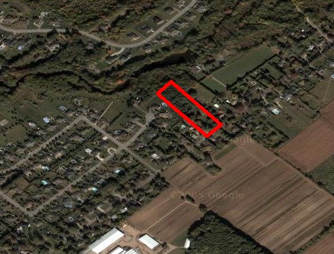
Go down and to the left and you see mostly new development in the last 10 or 15 years; up and to the right is still field, forest, and older houses. In a very real and physical sense, all those trees we planted as kids are now a sort of “last line of defense.”
About This Blog
 I am Peter Rukavina and this is my blog. I am a writer, letterpress printer, and a curious person.
To learn more about me, read my /now, look at my bio, listen to audio I’ve posted, read presentations and speeches I’ve written, see things I’ve favourited elsewhere, or get in touch (peter@rukavina.net is the quickest way).
I have been writing here since May 1999: you can explore the 25+ years of blog posts in the archive.
![]() You can subscribe to an RSS feed of posts, an RSS feed of comments, an RSS feed of favourites elsewhere, or a podcast RSS feed that just contains audio posts. You can also receive a daily digests of posts by email. I also publish an OPML blogroll.
You can subscribe to an RSS feed of posts, an RSS feed of comments, an RSS feed of favourites elsewhere, or a podcast RSS feed that just contains audio posts. You can also receive a daily digests of posts by email. I also publish an OPML blogroll.
Instagram • YouTube • Vimeo • ORCID • OpenStreetMap • Internet Archive • PEI.art • Drupal • Github.
Comments
I’ve been temporarily
I’ve been temporarily addicted to this Google Map thing. It’s tr
I could use a “firewall
I could use a “firewall against further residential development”, right about now. Check out the website above to see what I mean.
Add new comment