
I’m volunteering with the City of Charlottetown to create a General Transit Feed for public transit in the city.
This is an extension of work I started 10 years ago when the city first got a public transit system; I’d hoped that, in the intervening years, the schedule information would become professionalized, but that’s never happened, and we transit riders are still, all these years later, left with a complicated set of PDF files to navigate the system.
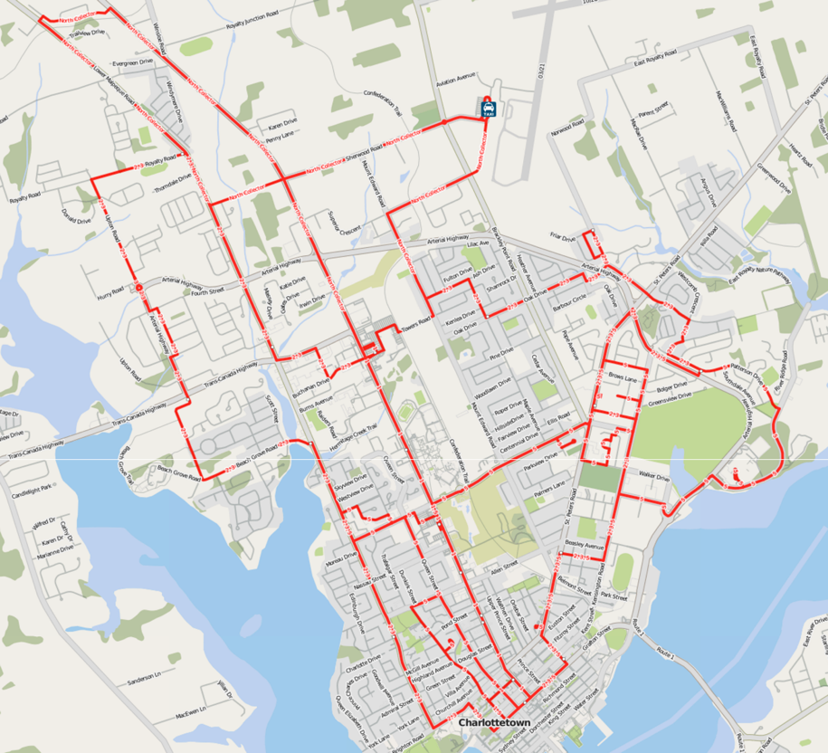
Because I’d already started the task of representing public transit routes in OpenStreetMap, it made sense to use that as the repository for the route and stop geography, so over the past few days I’ve worked to complete the job, representing all of the city routes – the main routes 1, 2, 3 along with the Winsloe/Airport Collector and the Community Bus – on the map. You can see the result below, or, on a slippy map, on the excellent ÖPNVKarte rendering (the “Transport” layer of OpenStreetMap itself should be updated within the next 24 hours).
The job was not without its challenges; the T3 Transit maps are not very granular, and it’s likely there’s some fine-tuning needed for the more complicated bits. I’ll have to ride the QEH & East Collector bus because there actually isn’t a map of that route at all, anywhere. It’s also somewhat confounding that some of the bus routes have numbers, others have names, and some have conflicting names (the schedule is labelled “Winsloe/Airport Collector” while the buses on that route are labelled “North Collector”).
My next task is to work on the feed: I’m using Drupal for that, building out the GTFS data model in Drupal content types with hopes that it can become a more generally useful tool for maintaining such feeds for small transit operators. Once I’ve got it working, I’ll publish the results.
And once everything’s worked out, I’ll send the feed, with the City’s cooperation, to Google and others that will read it.
Meaning that, sometime this winter, you should be able to use Google Maps to navigate Charlottetown by bus.
About This Blog
 I am Peter Rukavina and this is my blog. I am a writer, letterpress printer, and a curious person.
To learn more about me, read my /now, look at my bio, listen to audio I’ve posted, read presentations and speeches I’ve written, see things I’ve favourited elsewhere, or get in touch (peter@rukavina.net is the quickest way).
I have been writing here since May 1999: you can explore the 25+ years of blog posts in the archive.
![]() You can subscribe to an RSS feed of posts, an RSS feed of comments, an RSS feed of favourites elsewhere, or a podcast RSS feed that just contains audio posts. You can also receive a daily digests of posts by email. I also publish an OPML blogroll.
You can subscribe to an RSS feed of posts, an RSS feed of comments, an RSS feed of favourites elsewhere, or a podcast RSS feed that just contains audio posts. You can also receive a daily digests of posts by email. I also publish an OPML blogroll.
Instagram • YouTube • Vimeo • ORCID • OpenStreetMap • Internet Archive • PEI.art • Drupal • Github.
Comments
Great work, Peter!
Great work, Peter!
I'd love to see what you come
I'd love to see what you come up with in regards to the Drupal management of a GTFS feed. I'm actually looking at starting a similar project but I'm completely new to both GTFS and Drupal!!
Add new comment