
So I’ve become slightly obsessed with with the world of flight planning and trans-oceanic air travel: it’s a new puzzle to solve, and it involves things flying over my house on the way to far-off lands. What’s not to love?
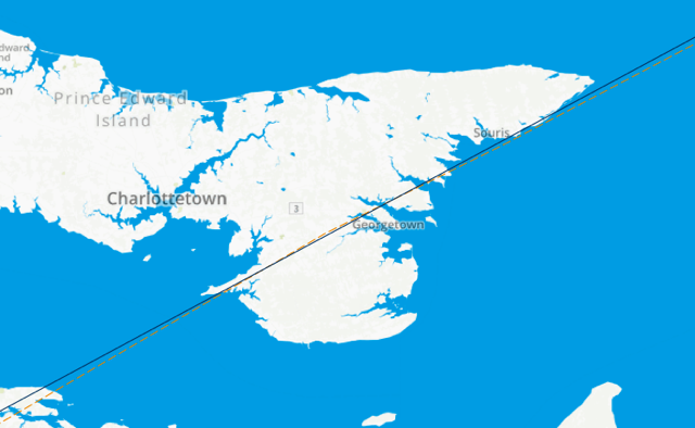
Last night around midnight, Aer Lingus Flight № 138 (code named EIN138), flying from Boston to Dublin, Ireland, flew over eastern PEI, making landfall near Point Prim, crossing south-eastern Kings County, continuing over Georgetown and Souris and heading off to sea. Here’s its track, from FlightAware.com:
Looking up flight EIN138 in FlightAware provides a lot of interesting information about the flight, including a section labeled “Route” in a box on the right:
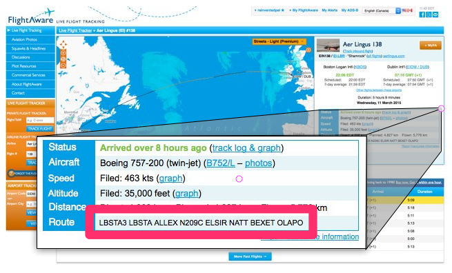
The route information is a series of “waypoints” – aeronautical bread crumbs, if you will – that EIN138 was to follow as it made its way from Boston to Dublin:
LBSTA3 LBSTA ALLEX N209C ELSIR NATT BEXET OLAPO
There is, oddly, no comprehensive database of these waypoints: there was a public resource called DAFIF, but it went dark in 2006, apparently amidst copyright concerns from Australia.
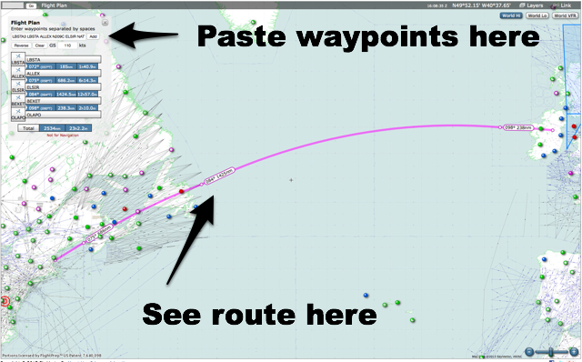
But there remain some web-based, if not open, data sources, that offer an incomplete way of looking up these waypoint codes, the most slick of which is Skyvector.com. You can simply paste the waypoints from FlightAware into Skyvector and it will, to the best of its ability, “connect the dots” (of the waypoints it knows about) and show you the flight plan on a map:
What’s most interesting, for my Prince Edward Island-focused purposes here, are two of those waypoints, ALLEX and ELSIR.
Zooming in a Skyvector.com, I can see the ALLEX is a waypoint at N44°25.00’, W67°.00.00’:
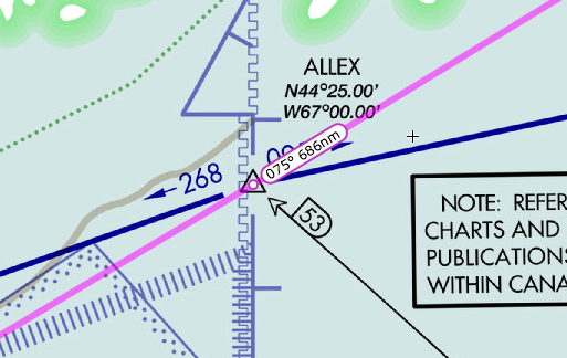
In decimal, that’s 44.416667, -67, which is a spot just inside Canadian airspace off Grand Manan, New Brunswick.
ELSIR, on the other hand, is at N49°30.09’, W52°0.17, or 49.5025, -52.004722 decimal, which is a spot in the North Atlantic off the east coast of Newfoundland:
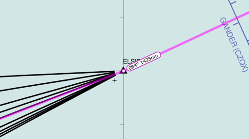
ELSIR is an interesting waypoint because it’s one of the official “aeronautical doorways” to flying across the North Atlantic: all airplanes flying across the ocean fly along prescribed North Atlantic Tracks, which change daily: last night, our Aer Lingus flight started its trans-oceanic voyage by passing over ELSIR.
Running between ALLEX and ELSIR is a line that happens to be labeled N209C (which also appears in the flight plan in FlightAware):
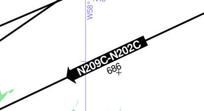
And N209C, because it connects ALLEX and ELSIR, runs directly over eastern Prince Edward Island:
All of which means, I’m assuming, that if you see ALLEX N209C ELSIR in a flight plan, it means that the plane in question will be flying over eastern Prince Edward Island.
Meanwhile, Aer Lingus Flight № 138 landed safely in Dublin at 7:16 a.m. this morning.
About This Blog
 I am Peter Rukavina and this is my blog. I am a writer, letterpress printer, and a curious person.
To learn more about me, read my /now, look at my bio, listen to audio I’ve posted, read presentations and speeches I’ve written, see things I’ve favourited elsewhere, or get in touch (peter@rukavina.net is the quickest way).
I have been writing here since May 1999: you can explore the 25+ years of blog posts in the archive.
![]() You can subscribe to an RSS feed of posts, an RSS feed of comments, an RSS feed of favourites elsewhere, or a podcast RSS feed that just contains audio posts. You can also receive a daily digests of posts by email. I also publish an OPML blogroll.
You can subscribe to an RSS feed of posts, an RSS feed of comments, an RSS feed of favourites elsewhere, or a podcast RSS feed that just contains audio posts. You can also receive a daily digests of posts by email. I also publish an OPML blogroll.
Instagram • YouTube • Vimeo • ORCID • OpenStreetMap • Internet Archive • PEI.art • Drupal • Github.
Comments
Hi Peter,
Hi Peter,
Cool that you are so interested.
One point: If you watch flights on Flightaware, you will see that they often don't actually fly all segments of a flight-planned route, and so they will often 'miss' navigation aids and waypoints on such a segment. This is because it is quite routine to be cleared 'present position direct' to points farther along. It happens just to save the flight time. Also, during convective weather, it often happens that a flight deviates to avoid thunderstorms that are showing up on the airplane's weather radar.
All the best,
Walt
Came across your post trying
Came across your post trying to find out just where in the world ELSIR is located. I became hooked on this amazing diversion after reading "Skyfaring" by Vanhoenacker. I expect I'm not the only one. Enjoyed your post. All good wishes from Orlando, Fl. - Alan
I also find air routing and
I also find air routing and maps in general very interesting, I found my way here looking for ALLEX location. I know FlightAware but wish more information were more easily found. Thanks!
Add new comment