
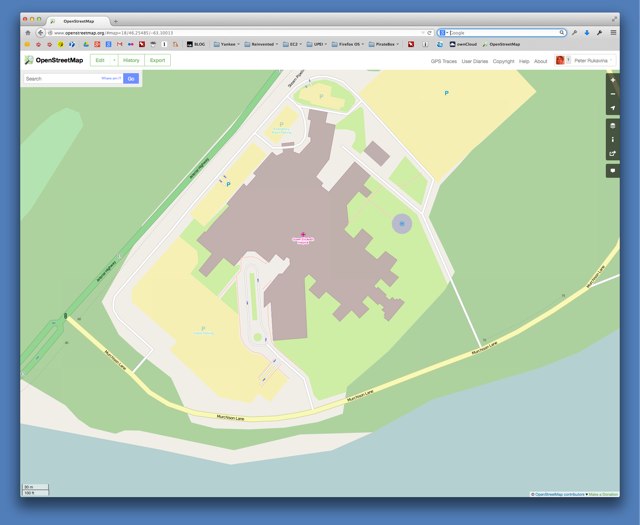
I updated Charlottetown’s Queen Elizabeth Hospital in OpenStreetMap this morning, as it has undergone quite a bit of change since it was first added there. I didn’t really grasp how much change had happened there until I did this.
Here’s what it looked like in OpenStreetMap before:

And here’s what it looks like now:
About This Blog
 I am Peter Rukavina and this is my blog. I am a writer, letterpress printer, and a curious person.
To learn more about me, read my /now, look at my bio, listen to audio I’ve posted, read presentations and speeches I’ve written, see things I’ve favourited elsewhere, or get in touch (peter@rukavina.net is the quickest way).
I have been writing here since May 1999: you can explore the 25+ years of blog posts in the archive.
![]() You can subscribe to an RSS feed of posts, an RSS feed of comments, an RSS feed of favourites elsewhere, or a podcast RSS feed that just contains audio posts. You can also receive a daily digests of posts by email. I also publish an OPML blogroll.
You can subscribe to an RSS feed of posts, an RSS feed of comments, an RSS feed of favourites elsewhere, or a podcast RSS feed that just contains audio posts. You can also receive a daily digests of posts by email. I also publish an OPML blogroll.
Instagram • YouTube • Vimeo • ORCID • OpenStreetMap • Internet Archive • PEI.art • Drupal • Github.
Comments
It looks like the original
It looks like the original outline is just not very detailed. The separate building on the new map was always present. The notable additions were a new ER, the ambulatory care centre and the cancer treatment centre. A new staff parking lot was opened to make up for the loss of the one that used to be where the ACC went in.
There is a model of the original layout of the hospital at the base of the main stairs. It’s great to look at to see the original naive aspirations of the architects, and how the original building turned out to be through the years.
Urban sprawl comes to IsLAND
Urban sprawl comes to IsLAND MEDICAL CARE. Perhaps if the architects had planned for future vertical expansion the place would not resemble the Blob that threatened to consume Hillsborough village.
Peter, our grade 4 class is
Peter, our grade 4 class is studying how to use blogs in Social Studies. Any thoughts on this subject? Please post. Thanks!
Add new comment