
Since I started experimenting with visualizing Prince Edward Island energy information over a year ago, one of the most important pieces missing from the data puzzle has been Island’s “load” — what the province calls “the amount of electricity required to power lights, motors, appliances and other users of electric energy in PEI.”
So, in other words, “how much electricity we 140,000-odd people (and our machines) are using.”
But last week the province started publishing that figure in near-real-time and so now we can generate graphs like this one, showing the load over the past 5 days (you might very well ask “what the heck is using 100MW of electricity in the middle of the night?” and I’ve posed that question to Maritime Electric and await an answer):
)
Now that we have that “total load” number, we can compare it to the “how much wind energy are we generating on the Island right now” figure, and so get a near-real-time percentage figure that looks like this for the past three hours:
)
(As I write this the figure is 1.26%, in part because there’s not a lot of wind blowing today and the load, at 162MW, is high).
Overlaying the wind energy generated (orange) on top of the load (black) for the past five days, you can see that once during that period (around midnight on June 23) we came really, really close to meeting 100% of our load with wind energy:
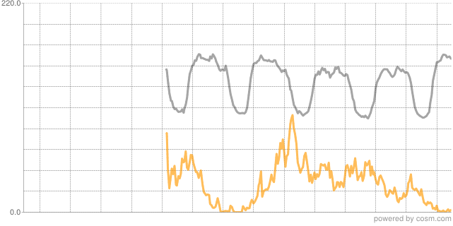
(Cosm doesn’t have the ability — I don’t think — to generate graphs with two data values, so I grabbed these individual graphs and combined them together myself manually).
The logical next step here is to create a physical device that I can place on my desk — a siren? an LED slider? a VU-meter? — that will offer instant feedback about what the current percentage figure is.
Note: in my calculations I’m using the figure for wind energy generated on PEI, regardless of whether it’s being generated to meet an export contract; like the province says, “usually all electricity generated in PEI remains on-Island,” which is to say that the electrons stay on the Island, even if the dollars come from elsewhere.
About This Blog
 I am Peter Rukavina and this is my blog. I am a writer, letterpress printer, and a curious person.
To learn more about me, read my /now, look at my bio, listen to audio I’ve posted, read presentations and speeches I’ve written, see things I’ve favourited elsewhere, or get in touch (peter@rukavina.net is the quickest way).
I have been writing here since May 1999: you can explore the 25+ years of blog posts in the archive.
![]() You can subscribe to an RSS feed of posts, an RSS feed of comments, an RSS feed of favourites elsewhere, or a podcast RSS feed that just contains audio posts. You can also receive a daily digests of posts by email. I also publish an OPML blogroll.
You can subscribe to an RSS feed of posts, an RSS feed of comments, an RSS feed of favourites elsewhere, or a podcast RSS feed that just contains audio posts. You can also receive a daily digests of posts by email. I also publish an OPML blogroll.
Instagram • YouTube • Vimeo • ORCID • OpenStreetMap • Internet Archive • PEI.art • Drupal • Github.
Comments
Maybe Johnny’s chair could go
Maybe Johnny’s chair could go up or down based on the percentage.
Not sure the electrons ever
Not sure the electrons ever “leave” as electrification is more about degrees of jiggling than a flow like water. The cables need to be balanced. Looks like the Northeast grid, of which PEI is part, has 3.3% wind as capacity but, as you note, this is different than load.
https://www.npcc.org/Library/S…
Update: I wrapped a single
Update: I wrapped a single-service-site around this data: energy.reinvented.net/wind.
That would be cool to have on
That would be cool to have on display in the lobby at Maritime Electric office.
This is awesome. I think we
This is awesome. I think we may have made the wind blow harder today.
Pinned as a firefox App Tab.
Pinned as a firefox App Tab. Thanks Peter
Dave pointed out to me via
Dave pointed out to me via email that the percentage number and the graph can appear out of sync. This is one of the perils of consuming data over which you have little control. What happens here is: the percentage number is pulled on every page load from www.gov.pe.ca onto my page; the data it’s pulling is updated on a not-revealed-by-government-yet schedule that appears to be about every 20 minutes. The graph, however, comes from Cosm (nee Pachube), which polls www.gov.pe.ca only every 15 minutes. As such, data, though from the same original source, is taking two different routes, and those routes aren’t in sync.
How about a date somewhere on
How about a date somewhere on the page? This would work as a reminder to update the page if needed or would be a convenient time stamp for saved views of interest.
Pleased to find this wind app
Pleased to find this wind app on-site.
Great information! Perhaps a
Great information! Perhaps a logical offshoot project would be to simulate the number of turbines required to produce 100% of PEI’s energy needs and overlay those on to a map of suitable wind farm real estate. Would PEI still be liveable? Perhaps the gov’t could buy everyone’s property, have them all move elsewhere and PEI become an unpopulated wind farm operated by drones, with an absentee gov’t perhaps living in the Cayman Islands. And no need for the bridge any longer …
Yes, I make fun, but wind farms just don’t make great places to live. As someone considering retirement to PEI, I’ve found it necessary to try and map out all the current (and possibly future) wind farm locations as a way of avoiding a terrible mistake. I can tell you it’s no easy task as information is hard to find. The gov’t 5 year plan produced in 2008 and showing “Designated Areas for Wind Development” shows at least 50 percent of coastal PEI so designated. And so far as I can tell, only a small portion of that has been developed. Honestly I laugh when wind farm promtional materials tout them as creating tourist revenue dollars!
Anyhow, your work shows clearly that with current wind farm production only meeting 1+ percent of need on an average winter day, serious questions should be raised about the human cost of reaching the additional 98+ percent.
Add new comment