
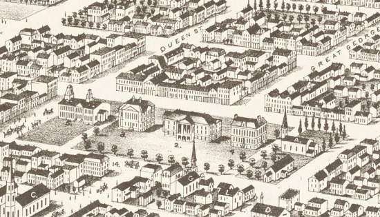
There’s a wonderful 1878 panoramic view of Charlottetown on view at the Confederation Centre Art Gallery. Last week Oliver and I spent a long time staring at it, looking for familiar buildings and streets; it’s a very approachable map, and captures the essence of the city 131 years ago in ways that a traditional map cannot. Here’s a detail from the map, showing the area around Province House (our house, which was built in 1827, is in the lower-right, near the corner of Prince and Richmond):
While it’s nice to see an original of the map on the wall, it’s not the best environment for really getting a good look at a map like this. Fortunately there’s a project underway at the Robertson Library at the University of PEI called Island Imagined that’s setting out to scan and enhance 1500 Prince Edward Island maps, this one among them. They were generous enough to move the 1878 panoramic to the front of the scanning queue for me, and sent along a high-resolution scan of the map (151 MB TIFF).
I’m using the map as a test-bed for experimenting with different ways of presenting high-resolution map images inside the browser.
Zoomify
Zoomify is a closed-source Flash-based system with a desktop client that takes the original image and slices it up into tiles at various resolutions that you can then feed to a Flash viewer in a web page. The upside of this approach is that it requires no applications at all on the server-side: you’re just serving up JPEG images into a Flash application; the downside is that it’s not a free solution, requiring the proprietary “zoomifier” application to create the tiled images.
OpenZoom
OpenZoom is a Flash-based “free & open source toolkit for delivering high-resolution images.” You can point the OpenZoom viewer at the same Zoomify-tiled images used with the Zoomify-viewer, making at least the client-side of the equation open source.
IIPImage
IIPImage is a (confusingly-named) open source client/server system for viewing high resolution images in the browser. It’s more complicated to get going than Zoomify or OpenZoom because it involves server-side setup of the IIPImage server as a FastCGI module, and configuration of the client-side Javascript-based IIPImage viewer. You also need to take your original image and turn it into a “Tiled Pyramid TIFF” (this is quite easy to do using ImageMagick).
The upside of IIPImage, through, is that it’s open source from end to end: the tiling and serving and the browser client are all freely available. I’ve run into some issues with Firefox on a Mac not missing tiles with IIPImage that I don’t experience in other browsers; I’ve yet to find a reason this is happening.
OpenLayers + Zoomify
The wonderful Old Maps Online project has hacked OpenLayers to support using Zoomify images as the tile source. This is a no-Flash-required solution that perhaps has the most potential has it’s open source on the client and server sides (with the exception of the initial “zoomification” step) and can leverage the considerable toolset that OpenLayers makes available for drawing, annotation and so on.
Next Steps
The Island Imagined project is looking at using OpenLayers on the client-side and Djatoka on the server side, so I may continue on in that direction for comparison.
In the meantime, enjoy the view of Charlottetown in 1878. Comments about what you find in your explorations are welcome.
About This Blog
 I am Peter Rukavina and this is my blog. I am a writer, letterpress printer, and a curious person.
To learn more about me, read my /now, look at my bio, listen to audio I’ve posted, read presentations and speeches I’ve written, see things I’ve favourited elsewhere, or get in touch (peter@rukavina.net is the quickest way).
I have been writing here since May 1999: you can explore the 25+ years of blog posts in the archive.
![]() You can subscribe to an RSS feed of posts, an RSS feed of comments, an RSS feed of favourites elsewhere, or a podcast RSS feed that just contains audio posts. You can also receive a daily digests of posts by email. I also publish an OPML blogroll.
You can subscribe to an RSS feed of posts, an RSS feed of comments, an RSS feed of favourites elsewhere, or a podcast RSS feed that just contains audio posts. You can also receive a daily digests of posts by email. I also publish an OPML blogroll.
Instagram • YouTube • Vimeo • ORCID • OpenStreetMap • Internet Archive • PEI.art • Drupal • Github.
Comments
I had no idea so much land
I had no idea so much land was reclaimed. This is great, thanks Peter.
Hi Peter,There is one more
Hi Peter,
There is one more option for you to view very high res images. Try using our zoom tool: Magic Touch. It’s free to use and you don’t need to “compose” the image. Magic Touch automatically fetches the image from your server, then serves the zoom from our server.
Give it a try!
Magic Touch image zoom
Thanks,
Simon
Peter,A friend sent me a link
Peter,
A friend sent me a link to this page just now and I was thrilled that the Ruger is now online in very big scale. For years I walked the streets of Charlottetown with this map in hand and still consider it the best “artefact” to begin to understand this city core which has remained virtually unchanged since about 1800. Now THAT unknown precious fact is worth a hundred thousand Anne of Green Boredoms.
Reg
Add new comment