The latest Hurricane Information Statement about Tropical Storm Noel says, in part:
We have nudged our forecast track west of the previous track and the latest cmc and gfs guidance suggests that it may not be far enough To the west. Because we are dealing with a large sprawling storm system by the time it reaches us we are cautious to make significant changes to the track in that the impacted areas will still be mostly The same… It is only the details that remain to be ironed out.
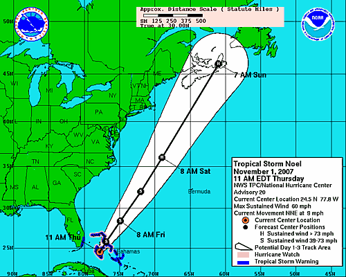
While it is refreshing to see such non-technical writing from an Official Government Source, the casual language hides the reality of the “nudge.” This morning’s storm path, grabbed and posted by Dan, shows Noel floating comfortably (for me) far away over Cape Breton:

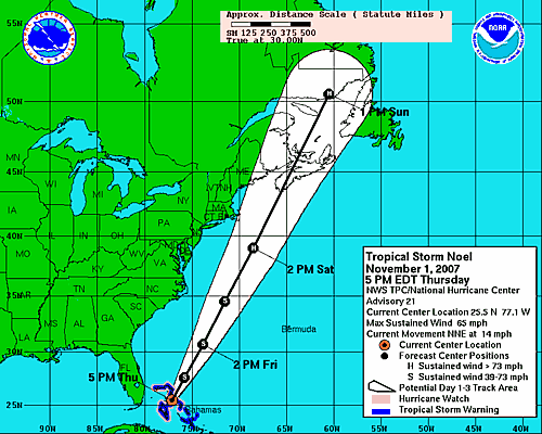
Post “nudge,” the track appears to place the eye of the hurricane-in-wait directly over where I am sitting right now:

Of course my lack of hurricane knowledge means that I may be mis-interpreting the relative merits of being in the path vs. being aside the path.
 I am
I am
Comments
The upper right (1st)
The upper right (1st) quadrant of a hurricane is the worst. This most recent path puts Charlottetown smack-dab in the middle of that.
Looks like the US Hurrican
Looks like the US Hurrican projection as of 5 AM Friday puts the track over Summerside…batten down the hatches!
From the latest update: “The
From the latest update: “The public is advised to not focus on the actual track of the storm center since the high winds and heavy rains will extend very from the track line itself.”
Most Cdn. Hurricane Centre
Most Cdn. Hurricane Centre meterologists try to use very plain non-scientific language in their “discussion” sections of storm forecasts. This one was no different and follows the pattern of the Nat. Hurricane Center in Miami…
Glad that it wasn’t a hurricane or tropical storm - still dangerous but glad it didn’t cause as much damage as it could have. And also glad it “nudged” further west.
It’s just like curling but
It’s just like curling but higher stakes.
Add new comment