
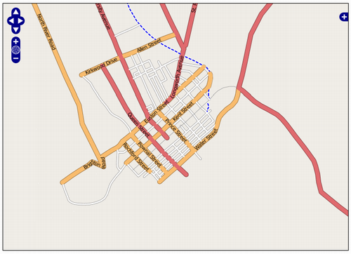
With recent updates to the front end “slippy map” at OpenStreetMap, all that cycling around with a GPS receiver in my pocket last summer now has a much more impressive gateway to the world. This map of downtown Charlottetown, for example — the results of my cycling labours — has colour-coded streets, street name labels, different rendering for the Confederation Trail and it works very “Google Maps-like” in that you can pan by dragging the map around. Neato.
About This Blog
 I am Peter Rukavina and this is my blog. I am a writer, letterpress printer, and a curious person.
To learn more about me, read my /now, look at my bio, listen to audio I’ve posted, read presentations and speeches I’ve written, see things I’ve favourited elsewhere, or get in touch (peter@rukavina.net is the quickest way).
I have been writing here since May 1999: you can explore the 25+ years of blog posts in the archive.
![]() You can subscribe to an RSS feed of posts, an RSS feed of comments, an RSS feed of favourites elsewhere, or a podcast RSS feed that just contains audio posts. You can also receive a daily digests of posts by email. I also publish an OPML blogroll.
You can subscribe to an RSS feed of posts, an RSS feed of comments, an RSS feed of favourites elsewhere, or a podcast RSS feed that just contains audio posts. You can also receive a daily digests of posts by email. I also publish an OPML blogroll.
Instagram • YouTube • Vimeo • ORCID • OpenStreetMap • Internet Archive • PEI.art • Drupal • Github.
Comments
What’s that little blip in
What’s that little blip in Brighton Road?
That’s interesting. I think
That’s interesting. I think I may have taken a wrong turn on my bicycle there. Have to fix that (nice thing about an open map is that I *can* fix it!)
Of course it’s an open map so
Of course it’s an open map so *you* could change it too ;-)
There are now four slices
There are now four slices above you with quite capable GPS receivers… I wonder how complete a city map we could make in month?
I’ve created an OpenStreetMap
I’ve created an OpenStreetMap wiki page for Charlottetown with some basic information about what’s been covered so far, and what needs to be done. If there’s interest out there in holding a “mapping day” for Charlottetown, beginning with a “how to gather GPS traces,” followed by a field day, followed by a “how to upload, tag and integrate what we’ve gathered” I’m willing to organize.
Add new comment