
The last time I went looking for a desktop GIS application for my Mac all I found was the beast of a system that is GRASS (it looked so powerful, but yet so far beyond my reach to properly grasp).
Suddenly it seems that GIS apps for the Mac are all over the place: Quantum GIS and uDIG are two I tried tonight with good success (both are cross-platform PC-Mac-Linux).
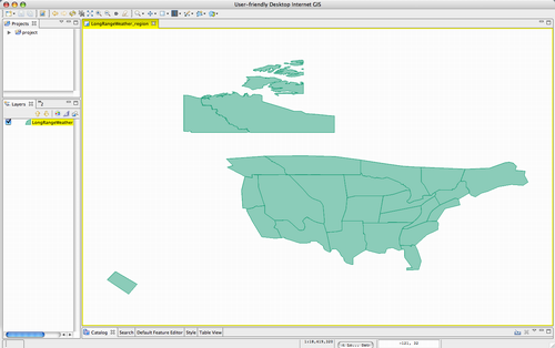
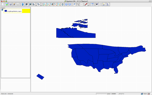
The task at hand was updating an old MapInfo layer of The Old Farmer’s Almanac long-range weather forecast regions and getting it ready to live as a MapServer-friendly SHP file.
I began by exporting the MapInfo file as an ESRI shapefile using the trial version of MapInfo running on my Mac using Virtual PC. Both Quantum GIS and uDig then opened this file with no problems:
Now the fun begins: I’ve got some “ZIP code in polygon” magic to perform and my next step is to see which tool supports this sort of thing best. Stay tuned.
Update: There’s also Thuban.
About This Blog
 I am Peter Rukavina and this is my blog. I am a writer, letterpress printer, and a curious person.
To learn more about me, read my /now, look at my bio, listen to audio I’ve posted, read presentations and speeches I’ve written, see things I’ve favourited elsewhere, or get in touch (peter@rukavina.net is the quickest way).
I have been writing here since May 1999: you can explore the 25+ years of blog posts in the archive.
![]() You can subscribe to an RSS feed of posts, an RSS feed of comments, an RSS feed of favourites elsewhere, or a podcast RSS feed that just contains audio posts. You can also receive a daily digests of posts by email. I also publish an OPML blogroll.
You can subscribe to an RSS feed of posts, an RSS feed of comments, an RSS feed of favourites elsewhere, or a podcast RSS feed that just contains audio posts. You can also receive a daily digests of posts by email. I also publish an OPML blogroll.
Instagram • YouTube • Vimeo • ORCID • OpenStreetMap • Internet Archive • PEI.art • Drupal • Github.
Comments
There’s also OSSIM.org which
There’s also OSSIM.org which is worth mentioning.
I’m not sure, but I think
I’m not sure, but I think QGIS should be able to read the MapInfo file due to its use of GDAL.
There is an excellent MacOS X
There is an excellent MacOS X installer for GRASS6.1 with support for integration into QGIS. Couple this with PostGIS, and you have a very flexible GIS system. Note that the GRASS installer for the mac comes with gdal. here is a link:
http://wwwamb.bologna.enea.it/…
For hard copy maps, GMT compiles easily on the mac.
cheers,
D
Question: Does ArcGIS running
Question: Does ArcGIS running in XP inside of Parallels or Bootcamp on OSX on an Intel Mac qualify as a GIS on a Mac? Works great.
Hi, you should try TNTlite
Hi, you should try TNTlite:
http://www.microimages.com/tnt…
I think it’s a great software
For Mac platfforms there are
For Mac platfforms there are TNTmips, which is a profeesioanl GIS and Remote sensing software, this tool is a strong rival for ESRI products, alos is a cross-platform between MAC, Win, Lunix and Solaris.
More information http://www.microimages.com
What about doing a brief side
What about doing a brief side-by-side comparison of the GIS packages for OSX? Or is that available somewhere else?
on this page you ll find all
on this page you ll find all kind of ressources which are GPS / GIS-related and working on Macs.
www.gueritte.net/geomax.html
So? How did it go?
So? How did it go? Inquiring minds want to know! :-)
There are some very
There are some very interesting developments like openjump or udig not mentioned here; but I will recommend to take a look to gvSIG that is a good alternative to grass and gqis http://gvsigmac.blogspot.com/2…
Yeah both Quantum GIS and
Yeah both Quantum GIS and uDIG are cross platform PC-Mac-Linux.I’ve tried them & they’re good one.Thanks.
Macken
cordless electric fillet knife
You can also try MacMap® (www
You can also try MacMap® (www.macmap.com). The trial version is available there…
For Mac platfforms there are
For Mac platfforms there are TNTmips, which is a profeesioanl GIS and Remote sensing software, this tool is a strong rival for ESRI products, alos is a cross-platform between MAC, Win, Lunix and Solaris. Also, both Quantum GIS and uDIG are cross platform PC-Mac-Linux.I’ve tried them & they’re good one.
You should try out
You should try out Cartographica from ClueTrust. You can download a copy and a trial license from www.macgis.com.
Add new comment