
I’m developing a follow-up application to the Interactive Charlottetown Bus Map that also uses the Google Maps API. During my experimenting, I started to notice that in the “hybrid” view, where the API returns a satellite map overlaid with a map, the streets in “reality” weren’t lining up with the streets on the map. It seems, however, that this isn’t a problem with Google’s own implementation of Google Maps. Witness the following examples:
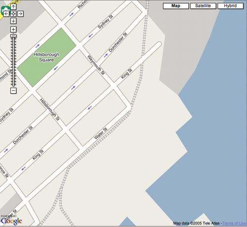
The map above is a screen snap of my application, which uses the Google Maps API. If you know Charlottetown, you’ll realize that the map information is out of date, showing railway tracks where none are, and not showing the addition to Water Street that was completed several years ago. Looking at the same area on Google’s own site shows a different, more up to date, data set:
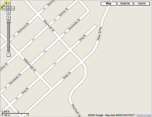
Notice how the railway tracks are gone and Water Street is extended. Additionally, in the “hybrid” view the streets in Google’s map “line up” with the satellite streets much better.
Am I missing something here? Do I need to flip a switch that I’m not flipping, or is Google simply serving more up-to-date maps for their own maps then they are for third-parties using the API?
About This Blog
 I am Peter Rukavina and this is my blog. I am a writer, letterpress printer, and a curious person.
To learn more about me, read my /now, look at my bio, listen to audio I’ve posted, read presentations and speeches I’ve written, see things I’ve favourited elsewhere, or get in touch (peter@rukavina.net is the quickest way).
I have been writing here since May 1999: you can explore the 25+ years of blog posts in the archive.
![]() You can subscribe to an RSS feed of posts, an RSS feed of comments, an RSS feed of favourites elsewhere, or a podcast RSS feed that just contains audio posts. You can also receive a daily digests of posts by email. I also publish an OPML blogroll.
You can subscribe to an RSS feed of posts, an RSS feed of comments, an RSS feed of favourites elsewhere, or a podcast RSS feed that just contains audio posts. You can also receive a daily digests of posts by email. I also publish an OPML blogroll.
Instagram • YouTube • Vimeo • ORCID • OpenStreetMap • Internet Archive • PEI.art • Drupal • Github.
Comments
Looking at the screen snaps a
Looking at the screen snaps a little more carefully, I notice that the “good” map is labeled “NAVTEQ” and the “bad” mad is labeled “Tele Atlas,” suggesting that Google is using a different data source for their maps and for the API-served maps, at least in Charlottetown.
Others have noted this for
Others have noted this for other areas: Just a statement about Navteq vs TeleAtlas, NAVTEQ or TeleAtlas, Differences in maps between GoogleMaps and maps API.
Here I am having a
Here I am having a conversation with myself: this post seems to have the definitive answer to the difference, from Google’s own mouth.
This explains my earlier
This explains my earlier comment about Kent street running one way in the wrong direction on your bus map. After I noticed that, I queried up Google’s own map and it showed Kent running the proper direction. This really confused me.
Tele Atlas is so far behind
Tele Atlas is so far behind that they’ll be ahead in a few years…
Hopefully high gas prices sees the railway return to this province one day in the future. A crying shame that the Ghiz government allowed itself to be bought off by Mulroney with money for roads. I guess more motorists and truckers vote than railroaders and the environment! Bike to the train, what a novel concept the Europeans have introduced.
Add new comment