
A perfect storm of technology became available this morning that allowed Dad and I to go on a wardriving expedition around Charlottetown — an upgrade from my earlier warwalking experiments.
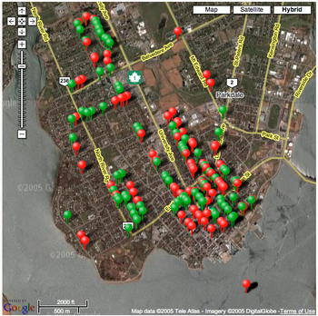
We ended up finding just over 200 wireless access points; put on a map they look like this (red markers are secured wifi access points, green markers are open ones):
In terms of gear, our setup looked like this:
- IBM ThinkPad T-20 laptop.
- NetStumbler software running under Windows 2000 on the laptop.
- An ancient Entrega 4-port USB hub.
- An ancient Holux GPS receiver, borrowed from Dan, plugged into the USB hub, and using some sort of weird “make my USB port into a serial port” driver.
- TRENDnet 54Mbps 802.11g Wireless USB 2.0 Adapter plugged into the USB hub.
- 400 W Eliminator Power Inverter from Canadian Tire.
- 2000 Volkswagen Jetta.
NetStumbler worked very well with Dad’s cheap USB wifi card and Dan’s GPS receiver; we needed the inverter in the car because the ThinkPad battery only lasts 15 minutes, and it only has one USB port where we needed two, thus the powered hub and the need to plug it in someplace.
I would be horrible if every asked to run a “grid pattern search” in a search and rescue situation, so our wardriving pattern wasn’t exactly comprehensive; we tried to get a representative sample from several neighbourhoods, but my sense is that there are 10-20x more access points out there that we missed.
Not sure how that one marker ended up out in Charlottetown Harbour — we didn’t actually drive the car out there.
If you want to fool with the raw data we gathered yourself, here are a couple of files:
I created the Google Maps map and the Google Earth datafile using the excellent GPSVisualizer site: it simply slurps in the NetStumbler files and spits out maps. Neato.
Some kids go hunting with their Dad, some kids play ball; I run wires all around my Volkswagen and go hunting for radio signals with my Dad.
About This Blog
 I am Peter Rukavina and this is my blog. I am a writer, letterpress printer, and a curious person.
To learn more about me, read my /now, look at my bio, listen to audio I’ve posted, read presentations and speeches I’ve written, see things I’ve favourited elsewhere, or get in touch (peter@rukavina.net is the quickest way).
I have been writing here since May 1999: you can explore the 25+ years of blog posts in the archive.
![]() You can subscribe to an RSS feed of posts, an RSS feed of comments, an RSS feed of favourites elsewhere, or a podcast RSS feed that just contains audio posts. You can also receive a daily digests of posts by email. I also publish an OPML blogroll.
You can subscribe to an RSS feed of posts, an RSS feed of comments, an RSS feed of favourites elsewhere, or a podcast RSS feed that just contains audio posts. You can also receive a daily digests of posts by email. I also publish an OPML blogroll.
Instagram • YouTube • Vimeo • ORCID • OpenStreetMap • Internet Archive • PEI.art • Drupal • Github.
Add new comment