
Sometime last year I resolved that if I was going to link to a business, institution, or anything else with a geographic location from one of my blog posts, I’d link to OpenStreetMap, and I’d use the opportunity either to create missing entities on the map, or to update those already there.
This approach has several benefits: it means I’m linking to real, useful information, as opposed to a business’ marketing websitem and it builds OpenStreetMap updating into a regular, natural habit.
Take this blog post about salted capers, for example, where I mentioned Riverview Country Market.
On my Mac I have an Alfred search set up that allows me to quickly get the URL on OpenStreetMap for something, just by pressing Control+Space and then typing map and then the name of the something, like this:

This search showed me that there was already an entity for Riverview Country Market on OpenStreetMap:
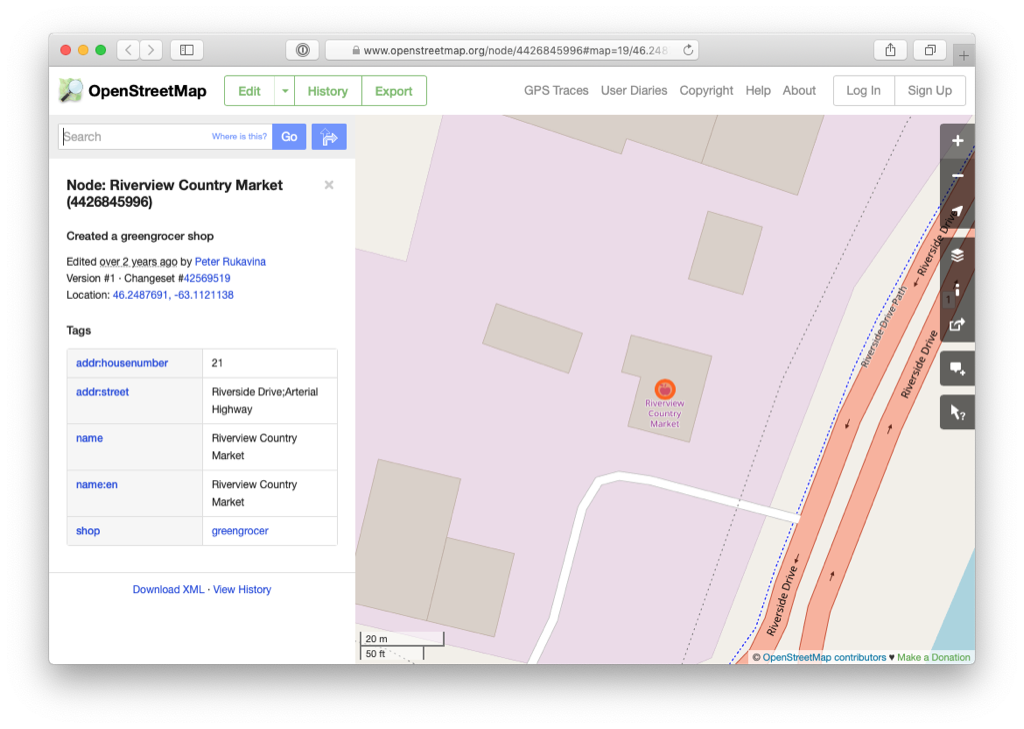
While Riverview was on the map (put there, as it turns out, by me, 2 years ago), the metadata about Riverview was incomplete, so I set out to enhance it by clicking Edit and logging in to OpenStreetMap (this is free, and anyone can do it).

Using the panel on the left, I did the following:
- I corrected the address, from “Riverside Drive;Arterial Highway” to just Riverside Drive.
- I added the missing city, province and postal code.
- I added Riverview’s opening hours, website, email address and a brief description.
- I moved the point for Riverview down slightly to allow me to also add a point for KJL Select Meats, which occupies the same building, and I added details for KJL as well.
- I added the parking lot and driveway.
Once I saved my edits, and waited a few minutes for the map tiles to get re-rendered, here’s the result of my changes:
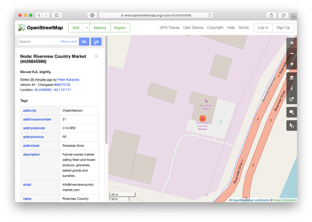
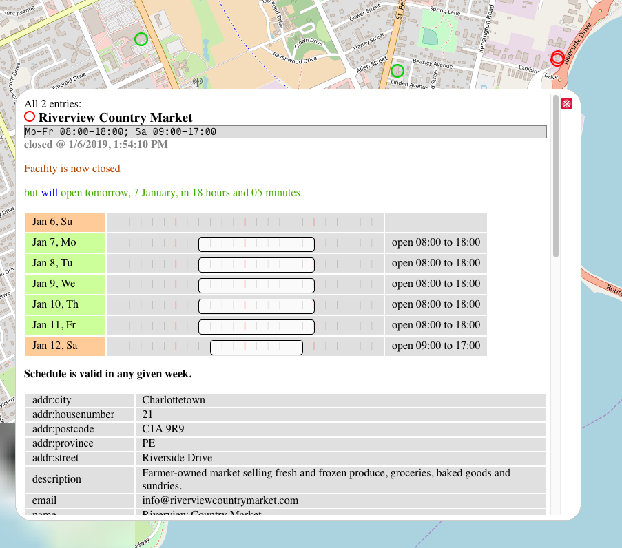
Now, granted, the rendering of the metadata for Riverview is more utilitarian than beautiful, but remember that I’ve just updated the the OpenStreetMap data from which all derivative products that use its data are drawn, from mobile apps to hiking maps to sites that show opening hours. So, for example, this website that draws an “open hours layer” on top of OpenStreetMap has already been updated:
Will you join me in this blogging habit?
About This Blog
 I am Peter Rukavina and this is my blog. I am a writer, letterpress printer, and a curious person.
To learn more about me, read my /now, look at my bio, listen to audio I’ve posted, read presentations and speeches I’ve written, see things I’ve favourited elsewhere, or get in touch (peter@rukavina.net is the quickest way).
I have been writing here since May 1999: you can explore the 25+ years of blog posts in the archive.
![]() You can subscribe to an RSS feed of posts, an RSS feed of comments, an RSS feed of favourites elsewhere, or a podcast RSS feed that just contains audio posts. You can also receive a daily digests of posts by email. I also publish an OPML blogroll.
You can subscribe to an RSS feed of posts, an RSS feed of comments, an RSS feed of favourites elsewhere, or a podcast RSS feed that just contains audio posts. You can also receive a daily digests of posts by email. I also publish an OPML blogroll.
Instagram • YouTube • Vimeo • ORCID • OpenStreetMap • Internet Archive • PEI.art • Drupal • Github.
Comments
Challenge accepted :) Manual
Challenge accepted :) Manual pingback: https://www.zylstra.org/blog/2019/01/my-first-open-street-map-edit/
And in turn another picked up
And in turn another picked up on it: https://www.jeremycherfas.net/blog/editing-open-street-maps
Add new comment