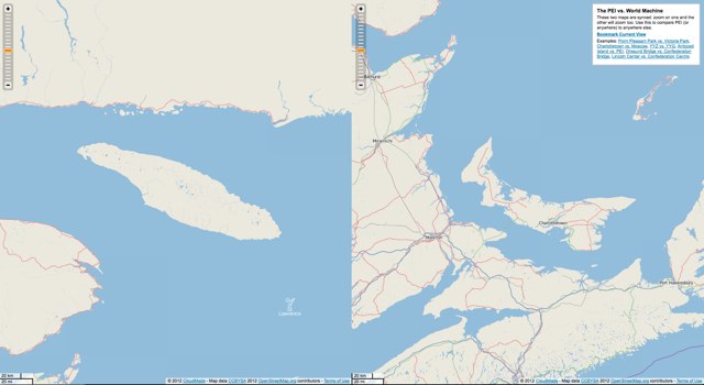
When you live in a place to which the adjective “small” is often applied (“small Island,” “Canada’s Smallest Province”, etc.), it’s easy to become a little obsessed with issues of relative geography. Just how small? So I built a little experiment — The PEI vs. The World Machine — to allow comparisons to be made. Like How big is Charlottetown’s airport compared to Toronto’s? or How big is the neighbourhood I grew up in compared to the neighbourhood where I live now? or How does Miami Beach compare to Cavendish Beach?.
Try it it for yourself: as you zoom one map, the other will zoom in sync. You can scroll either map to any location (meaning, of course, that you can use this to compare two places that aren’t Prince Edward Island too!).
Note: as latitude changes, so does the scale of the map, so watch the scale bar in the bottom-left of each map.

 I am
I am
Comments
Great tool !I think you
Great tool !
I think you should set this up for Moncton and Halifax. Whereas people in Charlottetown know we are small, these two places seem to think they are huge ;)
That’s cool. My office in
That’s cool. My office in Kingston is half the distance from the USA that my house in Rusticoville was to work in Charlottetown.
What fun and useful too.
What fun and useful too.
Very fun. Turns out Calgary’s
Very fun. Turns out Calgary’s current footprint would cover the part of Queens county I grew up in quite nicely. Cavendish to Rice Point - Cornwall to Crapaud. Our sprawl perhaps puts some of your recent road development in perspective. Also my current 2k walk to work along the Bow River and across the Peace Bridge is almost exactly the same distance as my drive from North River to UPEI across the North River Causeway was…I would never have considered walking but should have cycled it more. That said it is still quite an inhospitable route for either of those activities. Perhaps sidewalks/bike paths connecting Charlottetown and Cornwall would have been a better use for those infrastructure dollars.
Hi Peter, the map no longer
Hi Peter, the map no longer shows up. I've used it many times when it was up. Is there any chance of making it come alive again?
Add new comment