
Six years ago I built a little script to scrape all of the public GIS data from the Province of PEI’s GIS Data Layers website; the script still works, and you can grab it here.
By way of making sure it still works, I ran it, and grabbed all the data–1.2 GB in all.
One layer caught my eye in the downloads directory, Lidar_Ct.SHP. I loaded it up into QGIS and this lovely rendering of the Island appeared before me:
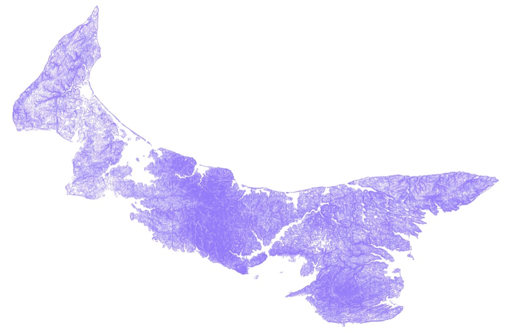
This is one of those situations where it’s helpful not to see the trees in the forest: zoom in closer and all you see is a confusing thicket of contour lines, but zoom out to the entire Island, and it’s rich Corinthian leather.
Want to try this at home? Follow these steps:
- Download an install QGIS (it’s free).
- Download and unzip the LIDAR GIS layer (that’s a direct-download link to save you steps).
- Open the resulting Lidar_Ct.shp file in QGIS.
- Enjoy.
About This Blog
 I am Peter Rukavina and this is my blog. I am a writer, letterpress printer, and a curious person.
To learn more about me, read my /now, look at my bio, listen to audio I’ve posted, read presentations and speeches I’ve written, see things I’ve favourited elsewhere, or get in touch (peter@rukavina.net is the quickest way).
I have been writing here since May 1999: you can explore the 25+ years of blog posts in the archive.
![]() You can subscribe to an RSS feed of posts, an RSS feed of comments, an RSS feed of favourites elsewhere, or a podcast RSS feed that just contains audio posts. You can also receive a daily digests of posts by email. I also publish an OPML blogroll.
You can subscribe to an RSS feed of posts, an RSS feed of comments, an RSS feed of favourites elsewhere, or a podcast RSS feed that just contains audio posts. You can also receive a daily digests of posts by email. I also publish an OPML blogroll.
Instagram • YouTube • Vimeo • ORCID • OpenStreetMap • Internet Archive • PEI.art • Drupal • Github.
Add new comment