
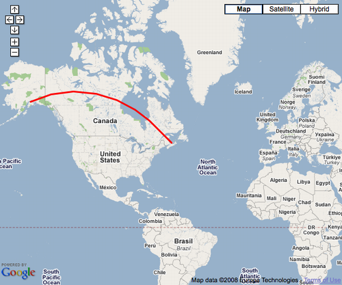
Someone came up to me in a coffee shop yesterday and told me they had a web application in which they wanted to connect two locations on a Google Map with a line. Not a regular straight line, but rather a curved “great circle” line. I mumbled about various possible approaches to this — setting up a custom tile-server and generating lines on the back end, etc. — only to find that this functionality is already build into the Google Maps API:
var polyOptions = {geodesic:true};
var polyline = new GPolyline([
  new GLatLng(61.1699849, -149.944496),
  new GLatLng(46.2361, -63.13)
  ], "#ff0000", 3, 1, polyOptions);
map.addOverlay(polyline);
Add an overlay like this — the key is the geodesic:true — and you go from straight line to curvy one. This is well-documented in the Google Maps API documentation.
About This Blog
 I am Peter Rukavina and this is my blog. I am a writer, letterpress printer, and a curious person.
To learn more about me, read my /now, look at my bio, listen to audio I’ve posted, read presentations and speeches I’ve written, see things I’ve favourited elsewhere, or get in touch (peter@rukavina.net is the quickest way).
I have been writing here since May 1999: you can explore the 25+ years of blog posts in the archive.
![]() You can subscribe to an RSS feed of posts, an RSS feed of comments, an RSS feed of favourites elsewhere, or a podcast RSS feed that just contains audio posts. You can also receive a daily digests of posts by email. I also publish an OPML blogroll.
You can subscribe to an RSS feed of posts, an RSS feed of comments, an RSS feed of favourites elsewhere, or a podcast RSS feed that just contains audio posts. You can also receive a daily digests of posts by email. I also publish an OPML blogroll.
Instagram • YouTube • Vimeo • ORCID • OpenStreetMap • Internet Archive • PEI.art • Drupal • Github.
Comments
If Google’s so geodesically
If Google’s so geodesically enlightened, why are they using that archaic projection that portrays Greenland as bigger than Africa?
You mean a “Mercator
You mean a "Mercator projection". It's not archaic. It's probably the most common type of projection used in cartography today, there are others of course, but anytime you put a 3D map on a 2D screen there must be some distortion somewhere.
I found this blog post on
I found this blog post on Google’s projection choice illuminating in this regard.
oliver because a sphere
oliver because a sphere cannot be shown in 2D map exactly as it is
Add new comment