
As a kind of beta test of a possible cycle ride from Charlottetown to South Melville, we drove the route in our car this afternoon as our way of getting from town to Crapaud for Oliver’s weekly art lesson.
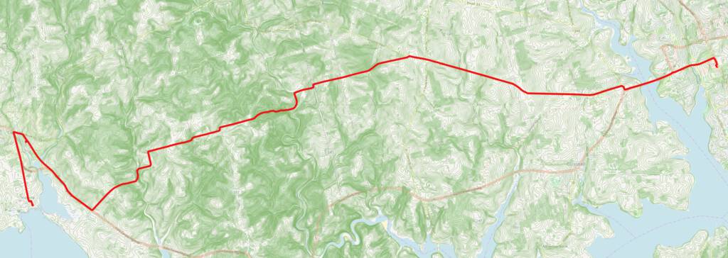
If you remember grade 10 geography, you will recall that the closer together contour lines are, the steeper the terrain: as you can see on the map here, which overlays our route (in red) on top of the province’s 2 metre contours layer, you can see that we got into some serious steepness once we turned left off the Kingston Road and entered the northern Bonshaw Hills.
Here’s the trip GPX file (recorded with OsmAnd) converted to an elevation profile by Trackreport.net (don’t compare the map above to the chart below, from left to right, as they run in opposite directions!):
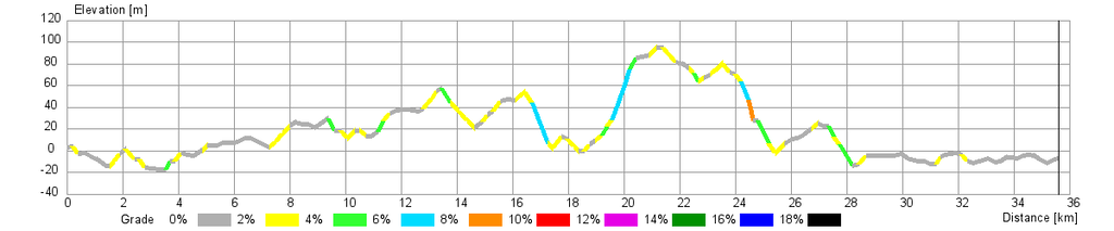
Not alpine terrain, certainly. But also not flat.
Once we left the Kingston Road it was mostly clay roads through to South Melville–some of the most beautiful roads you’ll ever drive. Not ideal terrain for a first-time longer-distance bicycle ride, electric-assisted or not. But certainly something to aspire to.
One of the less-recognized shames of the Plan B highway project is that there was no provision whatsoever made for cyclists when the new highway was constructed, despite that being the ideal–and perhaps only, in our lifetimes–opportunity to do so. Wouldn’t it have been amazing to have a separated cycleway running parallel to the route?
I did meet a gaggle of professional-looking cyclists in Victoria, and they’d cycled from town along the south shore, and spoke of the beauty of the route; perhaps that should be our next beta test.
About This Blog
 I am Peter Rukavina and this is my blog. I am a writer, letterpress printer, and a curious person.
To learn more about me, read my /now, look at my bio, listen to audio I’ve posted, read presentations and speeches I’ve written, see things I’ve favourited elsewhere, or get in touch (peter@rukavina.net is the quickest way).
I have been writing here since May 1999: you can explore the 25+ years of blog posts in the archive.
![]() You can subscribe to an RSS feed of posts, an RSS feed of comments, an RSS feed of favourites elsewhere, or a podcast RSS feed that just contains audio posts. You can also receive a daily digests of posts by email. I also publish an OPML blogroll.
You can subscribe to an RSS feed of posts, an RSS feed of comments, an RSS feed of favourites elsewhere, or a podcast RSS feed that just contains audio posts. You can also receive a daily digests of posts by email. I also publish an OPML blogroll.
Instagram • YouTube • Vimeo • ORCID • OpenStreetMap • Internet Archive • PEI.art • Drupal • Github.
Add new comment