
Some refinement of this weekend’s draft of a Charlottetown Subway Map. Switch from Arial Narrow to Futura for the body type; changed the name of the Nassau station to CBC to accommodate Kerry Campbell; moved the QEH stop from “future expansion” to the present day (why not just get it done!). Some design refinements as well, stealing some graphic inspiration from the Copenhagen Metro Map (in additional to the original design inspiration, of course, from Beck’s original Tube Map with its limitation of 45 and 90 degree angles).
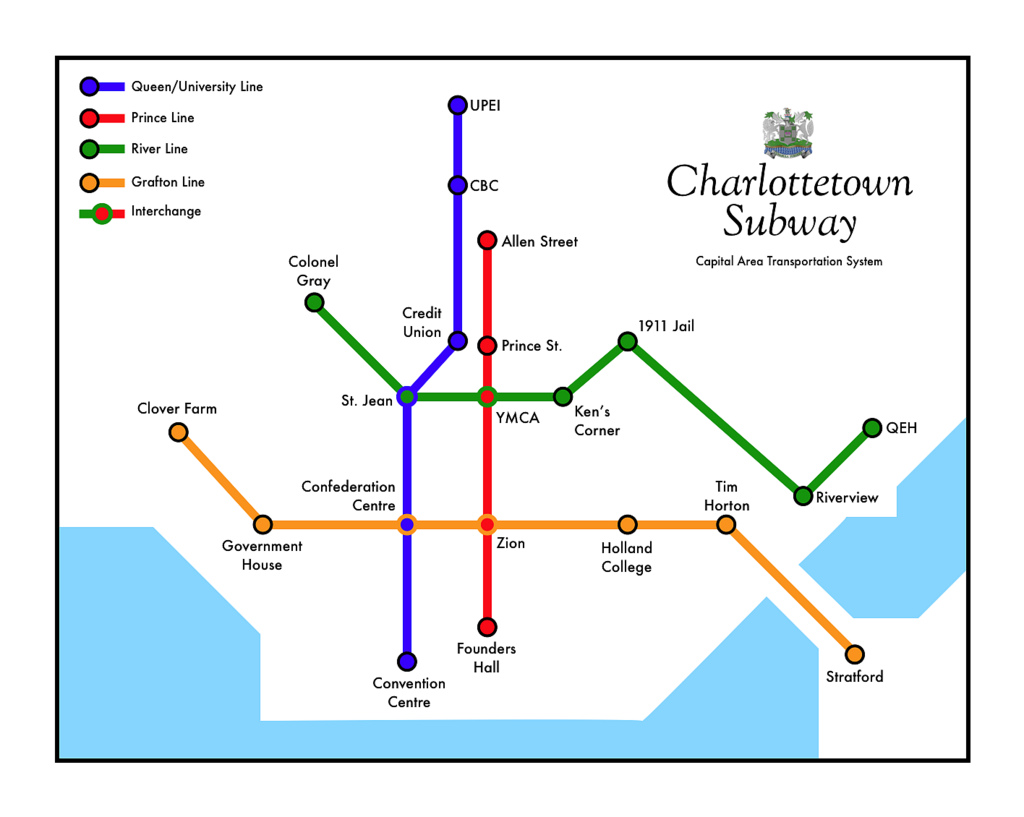
I’ve created a large suitable-for-printing version of the map if you seek to entertain and delight your friends and family.
About This Blog
 I am Peter Rukavina and this is my blog. I am a writer, letterpress printer, and a curious person.
To learn more about me, read my /now, look at my bio, listen to audio I’ve posted, read presentations and speeches I’ve written, see things I’ve favourited elsewhere, or get in touch (peter@rukavina.net is the quickest way).
I have been writing here since May 1999: you can explore the 25+ years of blog posts in the archive.
![]() You can subscribe to an RSS feed of posts, an RSS feed of comments, an RSS feed of favourites elsewhere, or a podcast RSS feed that just contains audio posts. You can also receive a daily digests of posts by email. I also publish an OPML blogroll.
You can subscribe to an RSS feed of posts, an RSS feed of comments, an RSS feed of favourites elsewhere, or a podcast RSS feed that just contains audio posts. You can also receive a daily digests of posts by email. I also publish an OPML blogroll.
Instagram • YouTube • Vimeo • ORCID • OpenStreetMap • Internet Archive • PEI.art • Drupal • Github.
Comments
Can the Queen/University line
Can the Queen/University line be expanded up to the Mall?
Why on earth would I want to
Why on earth would I want to encourage people to go to the mall?
Brilliant PeterLike the Beck
Brilliant Peter
Like the Beck map - it shows the key elements of the network that is Charlottetown - it explains the core of the place visually
Might the Clover farm line go
Might the Clover farm line go out to Cornwall? Metro Land!
Perhaps you shoudl do the map
Perhaps you shoudl do the map and schedule for the bus service, the current one is almost indecipherable and is, I’m sure, a deterant to ridership.
Add new comment