The code described here has been moved into Subversion.
Details and installation instructions.
Details and installation instructions.
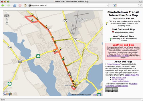
I don’t read printed bus timetables very well. So I created the Charlottetown Transit Interactive Bus Map:

This is a little Google Maps hack that uses PHP and JavaScript to display information about Charlottetown bus routes and schedules.
This is just a tentative first go; specifically:
- Only the Winsloe - University Ave. line is included (it’s the only one in operation as I write).
- Stop and route location may be incorrect; I simply recreated this as best I could from the published schedules and maps. If you find problems, please let me know.
- I left out the early morning and early evening swings to the Garfield St. terminal.
- Assumes a Big Browser Window (map is 700 pixels wide); future versions should be more flexible.
- No allowance made for the fact that there are no buses on Sundays.
- Doesn’t span days — after the transit day is over, all times display as “n/a”.
You’re welcome to grab the source and the data and improve. Steven says I need a source code repository for all my little code experiments; expect this soon.
It goes without saying that this project is unaffiliated with the City of Charlottetown or the transit operator; if it breaks, or sends you to the wrong place at the wrong time, it’s my fault, not theirs.
 I am
I am
Comments
There is no bus whatsoever on
There is no bus whatsoever on Sundays?? I know lots is closed, but people still need to get around on Sunday.
Cool! I hope the City runs
Cool! I hope the City runs with this and incorporates it into their website. Next step would be for each bus to have a GPS, and transmit real-time location coordinates, so that the map could display where the bus/trolleys actually are.
Off to look out the window to see if the bus actually shows up in front of my building at 08:18!
This is awesome.Awaiting the
This is awesome.
Awaiting the SVN/darcs repo with shiny eyes.
Bug in MySQL query found and
Bug in MySQL query found and corrected; corrected source to follow shortly.
A little more live tweaking
A little more live tweaking made things shaky for ~15 minutes, but we’re back. 9:54 a.m. bus just drove by (I heard the trolley bell, just like Mr. Rogers Neighbourhood).
Hi Peter,Nice work on the map
Hi Peter,
Nice work on the map. Although I am not seeing the stops coming up. I am testing with the Google Maps as well, hwo are you geocoding the points on the map? Any program or website you are using to get the coordinates?
Thanks
Actually, I see the points in
Actually, I see the points in Firefox but not in IE 6.
Did some searching around why
Did some searching around why it was not working with IE 6. Please check here to see how to get it working with IE.
http://www.google.com/apis/map…
Cheers
Is it possible to add the
Is it possible to add the option of Map, Satellite, and Hybrid to the top right of the map like regular google maps does?
Andrew: I’m reluctant to add
Andrew: I’m reluctant to add this because of the poor registration between the map layer and the satellite layer in Google Maps’ layers for Charlottetown. I’ve registered the bus routes against the map layer.
Peter,Nice work on the
Peter,
Nice work on the transit map. Thanks to your efforts I was able to create a couple of database-fed slides for the campus information system thing here at UPEI (Campus Screens Project).
It’s a pretty recent addition to the project, so it’s still pretty rough, but you can check it out here:
http://transit.upeiism.org/render.php?size=50&activestop=7&activeroute=1
Let us know what you think!
Cheers,
Ryan
that is a good ideait is so
that is a good idea
it is so kind of you shareing your code
:)
Peter:I am a transit
Peter:
I am a transit consultant specializing in small bus systems and I have been examining the parameters of the proposed transit study. Is there a person that I could communicate with regarding the current service and who will also be able to answer some questions about the community?
Thanks,
Bob Bourne
Ames, Iowa
great map and system. is
great map and system. is there a code or program that can be used offline for people who dont have internet so that they can use the map info.
There’s no code to allow for
There’s no code to allow for offline usage, but it’s conceivable that you could grab the MySQL data and craft your own.
Very interesting use of
Very interesting use of Google Maps.
thanks for sharing your ideas / process on this.
Dean
UK
Add new comment