
A friend, let’s call him “Bob Gray,” asked for advice on the best way to cycle from UPEI across town to Riverside Drive. I gave him my suggested route:
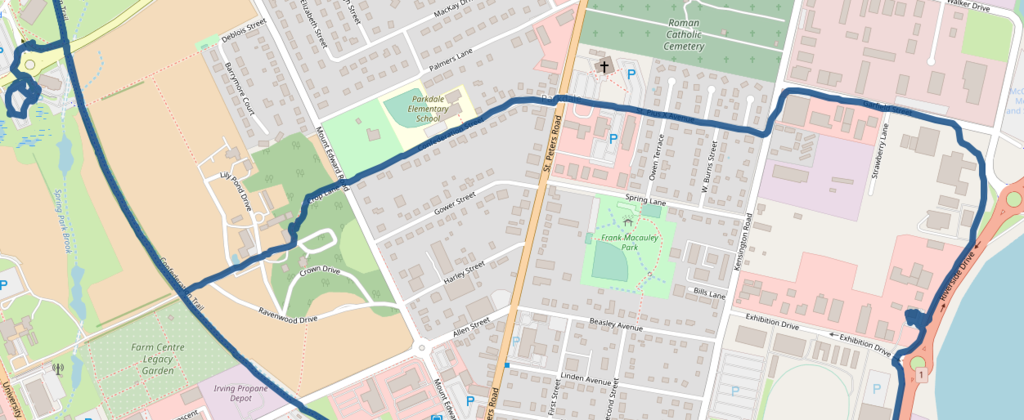
- Go down the trail from UPEI to the Experimental Farm road (by the beehives).
- Turn left, uphill, through the farm building complex to Crop Lane, which will lead you to Mt. Edward Road.
- Cross Mt. Edward Road to Confederation Street, past Parkdale Elementary School. Cross St. Peter’s Road and continue along St. Plus X to Kensington Road.
- Take a left then a right onto Garfield Street, which will lead you straight to the Riverside Drive trail.
On Saturday, after cycling out to Gallant’s for our smoked salmon bagels, and back to the Charlottetown Farmers’ Market for our weekly shop, our next stop was Riverview Country Market, and I resolved that we should subject ourselves to The Bob Gray Way to see whether it actually works.
Here’s the map of our complete 15 km Saturday cycle:
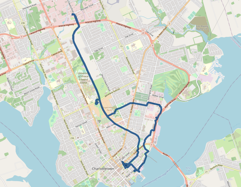
Here’s The Bob Gray Way:
We discovered some pitfalls:
- Crop Lane is almost impossible to find: it runs in from Mount Edward Road to the Experimental Farm, but in a non-obvious way that doesn’t connect to any of the other farm roads. You can cycle to it by going in back of a large farm building and going along a rough dirt trail.
- Garfield Street is rocky and sandy, has no shoulder, and vehicles don’t expect to find bicycles there, so it didn’t feel safe to cycle on. As you can see from our route on the map, we departed Garfield and cut through the Liquor Commission and Access PEI parking lots to avoid some of this.
- The Riverside Drive multi-use trail, which is a great gift to cyclists, is, nonetheless, somewhat harrowing to cycle: while it is physically separated from the roadway, when there’s a large transport truck using its air brakes a couple of metres away from you that physical separation doesn’t feel very comfortable.
On the upside, we avoided the Allen Street roundabout, the tricky Allen Street-St. Peters Road intersection, and Exhibition Drive.
But we had confirmed for us that east-west cycling in Charlottetown remains no easy feat.
As the area north of Exhibition Drive shifts quickly from industrial to residential, we should start thinking more about what the active transportation routes in and out of this area should be, and especially what the best way to safely connect to the Confederation Trail spine is.
About This Blog
 I am Peter Rukavina and this is my blog. I am a writer, letterpress printer, and a curious person.
To learn more about me, read my /now, look at my bio, listen to audio I’ve posted, read presentations and speeches I’ve written, see things I’ve favourited elsewhere, or get in touch (peter@rukavina.net is the quickest way).
I have been writing here since May 1999: you can explore the 25+ years of blog posts in the archive.
![]() You can subscribe to an RSS feed of posts, an RSS feed of comments, an RSS feed of favourites elsewhere, or a podcast RSS feed that just contains audio posts. You can also receive a daily digests of posts by email. I also publish an OPML blogroll.
You can subscribe to an RSS feed of posts, an RSS feed of comments, an RSS feed of favourites elsewhere, or a podcast RSS feed that just contains audio posts. You can also receive a daily digests of posts by email. I also publish an OPML blogroll.
Instagram • YouTube • Vimeo • ORCID • OpenStreetMap • Internet Archive • PEI.art • Drupal • Github.
Comments
Personally, I always stick to
Personally, I always stick to the trail as long as possible. In this case, I would have continued along on the trail, veering left at the fork just south of Kensington Rd, taking you through the Red Shores overflow parking lot at the east end of Beach St, leaving only a short dog leg on Park St to connect onto the Riverside Drive multi-use trail. From there you are a less than half a kilometer to Riverside Country Market. This route requires less than 200 meters of riding on street surfaces with other vehicles, and by my measurements is almost the exact trip distance as the "Bob Gray Way" (possibly slightly shorter).
That’s certainly our usual
That’s certainly our usual route. And it works well, with the exception of the intersections on Park Street, which are confusing to cars and bicycles both.
Add new comment