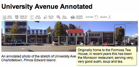
As a little experiment I shot a series of photos of the west side University Avenue between Kent and Fitzroy in downtown Charlottetown this morning. I stitched them together using the excellent Doubletake application, uploaded the resulting panorama into Flickr, and then used Flickr’s “Add Note” feature to add notes to the photo:

See the entire set of annotations here. This seems like an interesting way to layer comments and pointers and ideas over urban geography.
 I am
I am
Comments
Neat. If memory serves, Cedar
Neat. If memory serves, Cedar’s was torn down completely and rebuilt, a step beyond gutting.
Duly noted, Derek. Thanks.
Duly noted, Derek. Thanks.
This is a neat idea.
This is a neat idea.
I think this panorama would
I think this panorama would make an excellent jigsaw puzzle that would be an amazing souvenir for those cruise ship tourists!
Content notes: Fergie’s old
Content notes: Fergie’s old place is being renovated for an expansion of the adjacent (and, as you note, cramped) Maple Grill.
The sports bar is called the Sportsmen’s Club. Although ostensibly a private club, I believe they let everyone in (I have been there twice over the years, and am not, nor do I know, a member).
“Before it moved to the waterfront, the upper floors of this building were occupied by CFCY and CHLQ radio stations.”
I would suggest rewording to:
“The upper floors of this building were occupied by CFCY and CHLQ radio stations, before they moved to the waterfront”.
This clarifies that the radio stations, and not the building (or its upper floors) moved to the waterfront.
This is a really great way to annotate a neighborhood. I think that allowing users to post comments and corrections for each annotation would be the next logical step in its development.
Add new comment